Projection de la population en âge de travailler 2013-2040

Filtres actifs Tout effacer

Aucun filtre actif.
enregistrement
Filtres
x

enregistrement

Filtres

Description

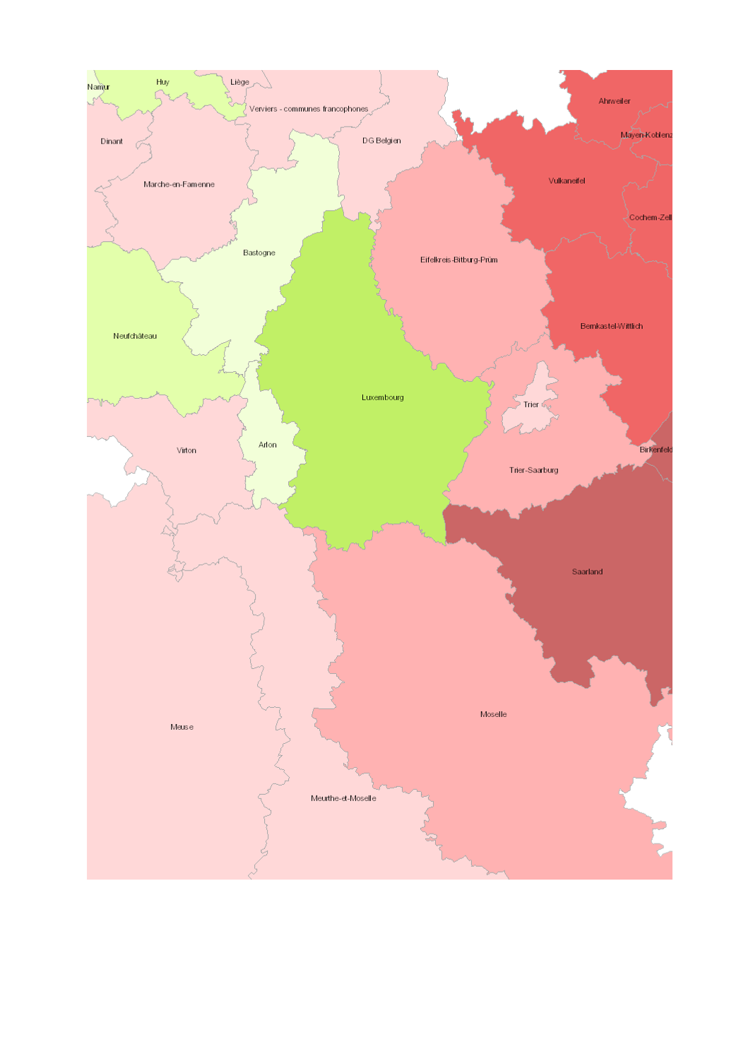
Projection de la population en âge de travailler (20-64 ans) 2013-2040

  • Unités territoriales: arrondissements (Wallonie), départements (Lorraine), Grand-Duché (Luxembourg), Kreise (Saarland, Rheinland-Pfalz)

  • Sources des données statistiques: Eurostat; INSEE Grand Est; Statec; SPF Economie; BFP-DGSIE; Statistisches Landesamt Rheinland-Pfalz; Statistisches Amt Saarland. Calculs: OIE/IBA 2016

  • Sources des données géographiques: EuroGeographics EuroRegionalMap v9.1 - 2016. Harmonisation: SIG-GR / GIS-GR 2016

Limites techniques d'usage

Aucune limite technique d'usage des données renseignée

Informations géographiques

Type de représentation: non renseignée

Etendue géographique:

  • Ouest: 2.84
  • Est: 8.68
  • Sud: 47.75
  • Nord: 51.04

Système de projection: http://www.opengis.net/def/crs/EPSG/0/3857

Echelle: 1/250000

Résolution: non renseignée

Mots clefs

DémographieDémographie Projection de la populationGrande RégionPopulation projection âge actifgis-gr.eu

Overview
Synthèse

Mise à jour quand nécessaire
Publié le 20 novembre 2018
Thèmes

Contacts

SIG-GR - Ministère de l'Energie et de l'Aménagement du territoire - Département de l'aménagement du territoire

4, Place de l'Europe

1499 Luxembourg

contact


Pièces jointes

Cliquez pour déplier Cliquez pour replier

Modèle de données

Cliquez pour déplier Cliquez pour replier
gml_id
Nom (identifiant)
gml_id
Type
texte
Description
                       
Aucune description n'est disponible pour ce champ.
Exemple
                   
geo_point_2d
Nom (identifiant)
geo_point_2d
Type
geo_point_2d
Description
                       
Aucune description n'est disponible pour ce champ.
Exemple
                   
objectid
Nom (identifiant)
objectid
Type
décimal
Description
                       
Aucune description n'est disponible pour ce champ.
Exemple
                   
name
Nom (identifiant)
name
Type
texte
Description
                       
Aucune description n'est disponible pour ce champ.
Exemple
                   
region
Nom (identifiant)
region
Type
texte
Description
                       
Aucune description n'est disponible pour ce champ.
Exemple
                   
de_entity
Nom (identifiant)
de_entity
Type
texte
Description
                       
Aucune description n'est disponible pour ce champ.
Exemple
                   
fr_entity
Nom (identifiant)
fr_entity
Type
texte
Description
                       
Aucune description n'est disponible pour ce champ.
Exemple
                   
pop_20_64_2013_2040
Nom (identifiant)
pop_20_64_2013_2040
Type
décimal
Description
                       
Aucune description n'est disponible pour ce champ.
Exemple
                   
pop_20_64_2013_2040_txt
Nom (identifiant)
pop_20_64_2013_2040_txt
Type
texte
Description
                       
Aucune description n'est disponible pour ce champ.
Exemple
                   
st_area_shape_
Nom (identifiant)
st_area_shape_
Type
décimal
Description
                       
Aucune description n'est disponible pour ce champ.
Exemple
                   
geo_shape
Nom (identifiant)
geo_shape
Type
geo_shape
Description
                       
Aucune description n'est disponible pour ce champ.
Exemple
                   

Schéma JSON

L'objet JSON ci dessous est une description standardisée du modèle de votre jeu de données. Pour en savoir plus sur JSON schema.

{
  • "title":"40e8cdf6-e80f-4367-a501-68a5788efe9f",
  • "type":"object",
  • "oneOf":
    [
    • {
      • "$ref":"#/definitions/40e8cdf6-e80f-4367-a501-68a5788efe9f"
      }
    ]
    ,
  • "definitions":
    {
    • "40e8cdf6-e80f-4367-a501-68a5788efe9f":
      {
      • "properties":
        {
        • "records":
          {
          • "type":"array",
          • "items":
            {
            • "$ref":"#/definitions/40e8cdf6-e80f-4367-a501-68a5788efe9f_records"
            }
          }
        }
      }
      ,
    • "geoJSON":
      {
      • "title":"Geo JSON object",
      • "description":"Schema for a Geo JSON object",
      • "type":"object",
      • "required":
        [
        • "type"
        ]
        ,
      • "properties":
        {
        • "crs":
          {
          • "$ref":"#/definitions/crs"
          }
          ,
        • "bbox":
          {
          • "$ref":"#/definitions/bbox"
          }
        }
        ,
      • "oneOf":
        [
        • {
          • "$ref":"#/definitions/geometry"
          }
          ,
        • {
          • "$ref":"#/definitions/geometryCollection"
          }
          ,
        • {
          • "$ref":"#/definitions/feature"
          }
          ,
        • {
          • "$ref":"#/definitions/featureCollection"
          }
        ]
      }
      ,
    • "bbox":
      {
      • "description":"A bounding box as defined by GeoJSON",
      • "type":"array",
      • "items":
        {
        • "type":"number"
        }
      }
      ,
    • "crs":
      {
      • "title":"crs",
      • "description":"a Coordinate Reference System object",
      • "type":
        [
        • "object",
        • "null"
        ]
        ,
      • "required":
        [
        • "type",
        • "properties"
        ]
        ,
      • "properties":
        {
        • "type":
          {
          • "type":"string"
          }
          ,
        • "properties":
          {
          • "type":"object"
          }
        }
        ,
      • "additionalProperties":false,
      • "oneOf":
        [
        • {
          • "$ref":"#/definitions/namedCrs"
          }
          ,
        • {
          • "$ref":"#/definitions/linkedCrs"
          }
        ]
      }
      ,
    • "namedCrs":
      {
      • "properties":
        {
        • "type":
          {
          • "enum":
            [
            • "name"
            ]
          }
          ,
        • "properties":
          {
          • "required":
            [
            • "name"
            ]
            ,
          • "additionalProperties":false,
          • "properties":
            {
            • "name":
              {
              • "type":"string"
              }
            }
          }
        }
      }
      ,
    • "linkedObject":
      {
      • "type":"object",
      • "required":
        [
        • "href"
        ]
        ,
      • "properties":
        {
        • "href":
          {
          • "type":"string",
          • "format":"uri"
          }
          ,
        • "type":
          {
          • "type":"string",
          • "description":"Suggested values: proj4, ogjwkt, esriwkt"
          }
        }
      }
      ,
    • "linkedCrs":
      {
      • "properties":
        {
        • "type":
          {
          • "enum":
            [
            • "link"
            ]
          }
          ,
        • "properties":
          {
          • "$ref":"#/definitions/linkedObject"
          }
        }
      }
      ,
    • "geometryCollection":
      {
      • "title":"GeometryCollection",
      • "description":"A collection of geometry objects",
      • "required":
        [
        • "geometries"
        ]
        ,
      • "properties":
        {
        • "type":
          {
          • "enum":
            [
            • "GeometryCollection"
            ]
          }
          ,
        • "geometries":
          {
          • "type":"array",
          • "items":
            {
            • "$ref":"http://json-schema.org/geojson/geometry.json#"
            }
          }
        }
      }
      ,
    • "feature":
      {
      • "title":"Feature",
      • "description":"A Geo JSON feature object",
      • "required":
        [
        • "geometry",
        • "properties"
        ]
        ,
      • "properties":
        {
        • "type":
          {
          • "enum":
            [
            • "Feature"
            ]
          }
          ,
        • "geometry":
          {
          • "oneOf":
            [
            • {
              • "type":"null"
              }
              ,
            • {
              • "$ref":"#/definitions/geometry"
              }
            ]
          }
          ,
        • "properties":
          {
          • "type":
            [
            • "object",
            • "null"
            ]
          }
          ,
        • "id":
          {
            }
          }
        }
        ,
      • "featureCollection":
        {
        • "title":"FeatureCollection",
        • "description":"A Geo JSON feature collection",
        • "required":
          [
          • "features"
          ]
          ,
        • "properties":
          {
          • "type":
            {
            • "enum":
              [
              • "FeatureCollection"
              ]
            }
            ,
          • "features":
            {
            • "type":"array",
            • "items":
              {
              • "$ref":"#/definitions/feature"
              }
            }
          }
        }
        ,
      • "geometry":
        {
        • "title":"geometry",
        • "description":"One geometry as defined by GeoJSON",
        • "type":"object",
        • "required":
          [
          • "type",
          • "coordinates"
          ]
          ,
        • "oneOf":
          [
          • {
            • "title":"Point",
            • "properties":
              {
              • "type":
                {
                • "enum":
                  [
                  • "Point"
                  ]
                }
                ,
              • "coordinates":
                {
                • "$ref":"#/definitions/position"
                }
              }
            }
            ,
          • {
            • "title":"MultiPoint",
            • "properties":
              {
              • "type":
                {
                • "enum":
                  [
                  • "MultiPoint"
                  ]
                }
                ,
              • "coordinates":
                {
                • "$ref":"#/definitions/positionArray"
                }
              }
            }
            ,
          • {
            • "title":"LineString",
            • "properties":
              {
              • "type":
                {
                • "enum":
                  [
                  • "LineString"
                  ]
                }
                ,
              • "coordinates":
                {
                • "$ref":"#/definitions/lineString"
                }
              }
            }
            ,
          • {
            • "title":"MultiLineString",
            • "properties":
              {
              • "type":
                {
                • "enum":
                  [
                  • "MultiLineString"
                  ]
                }
                ,
              • "coordinates":
                {
                • "type":"array",
                • "items":
                  {
                  • "$ref":"#/definitions/lineString"
                  }
                }
              }
            }
            ,
          • {
            • "title":"Polygon",
            • "properties":
              {
              • "type":
                {
                • "enum":
                  [
                  • "Polygon"
                  ]
                }
                ,
              • "coordinates":
                {
                • "$ref":"#/definitions/polygon"
                }
              }
            }
            ,
          • {
            • "title":"MultiPolygon",
            • "properties":
              {
              • "type":
                {
                • "enum":
                  [
                  • "MultiPolygon"
                  ]
                }
                ,
              • "coordinates":
                {
                • "type":"array",
                • "items":
                  {
                  • "$ref":"#/definitions/polygon"
                  }
                }
              }
            }
          ]
          ,
        • "position":
          {
          • "description":"A single position",
          • "type":"array",
          • "minItems":2,
          • "items":
            [
            • {
              • "type":"number"
              }
              ,
            • {
              • "type":"number"
              }
            ]
            ,
          • "additionalItems":false
          }
          ,
        • "positionArray":
          {
          • "description":"An array of positions",
          • "type":"array",
          • "items":
            {
            • "$ref":"#/definitions/position"
            }
          }
          ,
        • "lineString":
          {
          • "description":"An array of two or more positions",
          • "allOf":
            [
            • {
              • "$ref":"#/definitions/positionArray"
              }
              ,
            • {
              • "minItems":2
              }
            ]
          }
          ,
        • "linearRing":
          {
          • "description":"An array of four positions where the first equals the last",
          • "allOf":
            [
            • {
              • "$ref":"#/definitions/positionArray"
              }
              ,
            • {
              • "minItems":4
              }
            ]
          }
          ,
        • "polygon":
          {
          • "description":"An array of linear rings",
          • "type":"array",
          • "items":
            {
            • "$ref":"#/definitions/linearRing"
            }
          }
        }
        ,
      • "40e8cdf6-e80f-4367-a501-68a5788efe9f_records":
        {
        • "properties":
          {
          • "fields":
            {
            • "type":"object",
            • "properties":
              {
              • "gml_id":
                {
                • "type":"string",
                • "title":"gml_id",
                • "description":""
                }
                ,
              • "geo_point_2d":
                {
                • "type":"array",
                • "minItems":2,
                • "maxItems":2,
                • "items":
                  {
                  • "type":"number"
                  }
                  ,
                • "title":"geo_point_2d",
                • "description":""
                }
                ,
              • "objectid":
                {
                • "type":"number",
                • "title":"objectid",
                • "description":""
                }
                ,
              • "name":
                {
                • "type":"string",
                • "title":"name",
                • "description":""
                }
                ,
              • "region":
                {
                • "type":"string",
                • "title":"region",
                • "description":""
                }
                ,
              • "de_entity":
                {
                • "type":"string",
                • "title":"de_entity",
                • "description":""
                }
                ,
              • "fr_entity":
                {
                • "type":"string",
                • "title":"fr_entity",
                • "description":""
                }
                ,
              • "pop_20_64_2013_2040":
                {
                • "type":"number",
                • "title":"pop_20_64_2013_2040",
                • "description":""
                }
                ,
              • "pop_20_64_2013_2040_txt":
                {
                • "type":"string",
                • "title":"pop_20_64_2013_2040_txt",
                • "description":""
                }
                ,
              • "st_area_shape_":
                {
                • "type":"number",
                • "title":"st_area_shape_",
                • "description":""
                }
                ,
              • "geo_shape":
                {
                • "type":"object",
                • "oneOf":
                  [
                  • {
                    • "$ref":"#/definitions/geometry"
                    }
                  ]
                  ,
                • "title":"geo_shape",
                • "description":""
                }
              }
            }
          }
        }
      }
    }
    objectid
    pop_20_64_2013_2040
    st_area_shape_
    de_entity
    fr_entity
    geo_point_2d
    geo_shape
    gml_id
    name
    pop_20_64_2013_2040_txt
    region
    objectid
    pop_20_64_2013_2040
    st_area_shape_
    de_entity
    fr_entity
    geo_point_2d
    geo_shape
    gml_id
    name
    pop_20_64_2013_2040_txt
    region
    Aucun résultat
      ×