Frontaliers de la Wallonie vers la France 2011-2019

Filtres actifs Tout effacer

Aucun filtre actif.

Jeu de données affiché :

enregistrement
Filtres
x

enregistrement

Filtres

Description

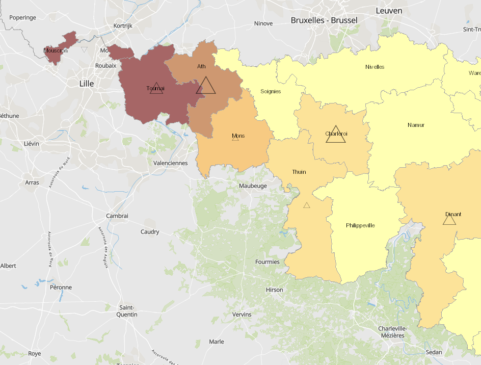
  • Flux frontaliers de la Wallonie vers la France par lieu de résidence (arrondissements) : 2011-2019

  • Unités territoriales: Arrondissements

  • Sources des données sur les frontaliers: INAMI 2020. Calculs: OIE/IBA 2020

  • Sources des données géographiques: NGI-Belgium 2017. Harmonisation: SIG-GR / GIS-GR 2020

Limites techniques d'usage

Aucune limite technique d'usage des données renseignée

Informations géographiques

Type de représentation: non renseignée

Etendue géographique:

  • Ouest: 2.84
  • Est: 6.44
  • Sud: 49.48
  • Nord: 50.84

Système de projection: http://www.opengis.net/def/crs/EPSG/0/3857

Echelle: 1/250000

Résolution: non renseignée

Mots clefs

Emploi frontaliersGrande RégionMarché du travailMarché du travail Flux frontaliers entre la Wallonie et la Francegis-gr.eu

Overview
Synthèse

Mise à jour en continu
Publié le 16 février 2021
Thèmes

Contacts

SIG-GR - Ministère de l'Energie et de l'Aménagement du territoire - Département de l'aménagement du territoire

4, Place de l'Europe

1499 Luxembourg

contact


Pièces jointes

Cliquez pour déplier Cliquez pour replier

Modèle de données

Cliquez pour déplier Cliquez pour replier
gml_id
Nom (identifiant)
gml_id
Type
texte
Description
                       
Aucune description n'est disponible pour ce champ.
Exemple
                   
geo_point_2d
Nom (identifiant)
geo_point_2d
Type
geo_point_2d
Description
                       
Aucune description n'est disponible pour ce champ.
Exemple
                   
objectid
Nom (identifiant)
objectid
Type
décimal
Description
                       
Aucune description n'est disponible pour ce champ.
Exemple
                   
nbr_2011
Nom (identifiant)
nbr_2011
Type
décimal
Description
                       
Aucune description n'est disponible pour ce champ.
Exemple
                   
nbr_2019
Nom (identifiant)
nbr_2019
Type
décimal
Description
                       
Aucune description n'est disponible pour ce champ.
Exemple
                   
evo_2011_2019
Nom (identifiant)
evo_2011_2019
Type
décimal
Description
                       
Aucune description n'est disponible pour ce champ.
Exemple
                   
st_area_shape_
Nom (identifiant)
st_area_shape_
Type
décimal
Description
                       
Aucune description n'est disponible pour ce champ.
Exemple
                   
st_length_shape_
Nom (identifiant)
st_length_shape_
Type
décimal
Description
                       
Aucune description n'est disponible pour ce champ.
Exemple
                   
geo_shape
Nom (identifiant)
geo_shape
Type
geo_shape
Description
                       
Aucune description n'est disponible pour ce champ.
Exemple
                   

Schéma JSON

L'objet JSON ci dessous est une description standardisée du modèle de votre jeu de données. Pour en savoir plus sur JSON schema.

{
  • "title":"518de640-de69-4744-bf82-6b4f4ba68c51",
  • "type":"object",
  • "oneOf":
    [
    • {
      • "$ref":"#/definitions/518de640-de69-4744-bf82-6b4f4ba68c51"
      }
    ]
    ,
  • "definitions":
    {
    • "518de640-de69-4744-bf82-6b4f4ba68c51":
      {
      • "properties":
        {
        • "records":
          {
          • "type":"array",
          • "items":
            {
            • "$ref":"#/definitions/518de640-de69-4744-bf82-6b4f4ba68c51_records"
            }
          }
        }
      }
      ,
    • "geoJSON":
      {
      • "title":"Geo JSON object",
      • "description":"Schema for a Geo JSON object",
      • "type":"object",
      • "required":
        [
        • "type"
        ]
        ,
      • "properties":
        {
        • "crs":
          {
          • "$ref":"#/definitions/crs"
          }
          ,
        • "bbox":
          {
          • "$ref":"#/definitions/bbox"
          }
        }
        ,
      • "oneOf":
        [
        • {
          • "$ref":"#/definitions/geometry"
          }
          ,
        • {
          • "$ref":"#/definitions/geometryCollection"
          }
          ,
        • {
          • "$ref":"#/definitions/feature"
          }
          ,
        • {
          • "$ref":"#/definitions/featureCollection"
          }
        ]
      }
      ,
    • "bbox":
      {
      • "description":"A bounding box as defined by GeoJSON",
      • "type":"array",
      • "items":
        {
        • "type":"number"
        }
      }
      ,
    • "crs":
      {
      • "title":"crs",
      • "description":"a Coordinate Reference System object",
      • "type":
        [
        • "object",
        • "null"
        ]
        ,
      • "required":
        [
        • "type",
        • "properties"
        ]
        ,
      • "properties":
        {
        • "type":
          {
          • "type":"string"
          }
          ,
        • "properties":
          {
          • "type":"object"
          }
        }
        ,
      • "additionalProperties":false,
      • "oneOf":
        [
        • {
          • "$ref":"#/definitions/namedCrs"
          }
          ,
        • {
          • "$ref":"#/definitions/linkedCrs"
          }
        ]
      }
      ,
    • "namedCrs":
      {
      • "properties":
        {
        • "type":
          {
          • "enum":
            [
            • "name"
            ]
          }
          ,
        • "properties":
          {
          • "required":
            [
            • "name"
            ]
            ,
          • "additionalProperties":false,
          • "properties":
            {
            • "name":
              {
              • "type":"string"
              }
            }
          }
        }
      }
      ,
    • "linkedObject":
      {
      • "type":"object",
      • "required":
        [
        • "href"
        ]
        ,
      • "properties":
        {
        • "href":
          {
          • "type":"string",
          • "format":"uri"
          }
          ,
        • "type":
          {
          • "type":"string",
          • "description":"Suggested values: proj4, ogjwkt, esriwkt"
          }
        }
      }
      ,
    • "linkedCrs":
      {
      • "properties":
        {
        • "type":
          {
          • "enum":
            [
            • "link"
            ]
          }
          ,
        • "properties":
          {
          • "$ref":"#/definitions/linkedObject"
          }
        }
      }
      ,
    • "geometryCollection":
      {
      • "title":"GeometryCollection",
      • "description":"A collection of geometry objects",
      • "required":
        [
        • "geometries"
        ]
        ,
      • "properties":
        {
        • "type":
          {
          • "enum":
            [
            • "GeometryCollection"
            ]
          }
          ,
        • "geometries":
          {
          • "type":"array",
          • "items":
            {
            • "$ref":"http://json-schema.org/geojson/geometry.json#"
            }
          }
        }
      }
      ,
    • "feature":
      {
      • "title":"Feature",
      • "description":"A Geo JSON feature object",
      • "required":
        [
        • "geometry",
        • "properties"
        ]
        ,
      • "properties":
        {
        • "type":
          {
          • "enum":
            [
            • "Feature"
            ]
          }
          ,
        • "geometry":
          {
          • "oneOf":
            [
            • {
              • "type":"null"
              }
              ,
            • {
              • "$ref":"#/definitions/geometry"
              }
            ]
          }
          ,
        • "properties":
          {
          • "type":
            [
            • "object",
            • "null"
            ]
          }
          ,
        • "id":
          {
            }
          }
        }
        ,
      • "featureCollection":
        {
        • "title":"FeatureCollection",
        • "description":"A Geo JSON feature collection",
        • "required":
          [
          • "features"
          ]
          ,
        • "properties":
          {
          • "type":
            {
            • "enum":
              [
              • "FeatureCollection"
              ]
            }
            ,
          • "features":
            {
            • "type":"array",
            • "items":
              {
              • "$ref":"#/definitions/feature"
              }
            }
          }
        }
        ,
      • "geometry":
        {
        • "title":"geometry",
        • "description":"One geometry as defined by GeoJSON",
        • "type":"object",
        • "required":
          [
          • "type",
          • "coordinates"
          ]
          ,
        • "oneOf":
          [
          • {
            • "title":"Point",
            • "properties":
              {
              • "type":
                {
                • "enum":
                  [
                  • "Point"
                  ]
                }
                ,
              • "coordinates":
                {
                • "$ref":"#/definitions/position"
                }
              }
            }
            ,
          • {
            • "title":"MultiPoint",
            • "properties":
              {
              • "type":
                {
                • "enum":
                  [
                  • "MultiPoint"
                  ]
                }
                ,
              • "coordinates":
                {
                • "$ref":"#/definitions/positionArray"
                }
              }
            }
            ,
          • {
            • "title":"LineString",
            • "properties":
              {
              • "type":
                {
                • "enum":
                  [
                  • "LineString"
                  ]
                }
                ,
              • "coordinates":
                {
                • "$ref":"#/definitions/lineString"
                }
              }
            }
            ,
          • {
            • "title":"MultiLineString",
            • "properties":
              {
              • "type":
                {
                • "enum":
                  [
                  • "MultiLineString"
                  ]
                }
                ,
              • "coordinates":
                {
                • "type":"array",
                • "items":
                  {
                  • "$ref":"#/definitions/lineString"
                  }
                }
              }
            }
            ,
          • {
            • "title":"Polygon",
            • "properties":
              {
              • "type":
                {
                • "enum":
                  [
                  • "Polygon"
                  ]
                }
                ,
              • "coordinates":
                {
                • "$ref":"#/definitions/polygon"
                }
              }
            }
            ,
          • {
            • "title":"MultiPolygon",
            • "properties":
              {
              • "type":
                {
                • "enum":
                  [
                  • "MultiPolygon"
                  ]
                }
                ,
              • "coordinates":
                {
                • "type":"array",
                • "items":
                  {
                  • "$ref":"#/definitions/polygon"
                  }
                }
              }
            }
          ]
          ,
        • "position":
          {
          • "description":"A single position",
          • "type":"array",
          • "minItems":2,
          • "items":
            [
            • {
              • "type":"number"
              }
              ,
            • {
              • "type":"number"
              }
            ]
            ,
          • "additionalItems":false
          }
          ,
        • "positionArray":
          {
          • "description":"An array of positions",
          • "type":"array",
          • "items":
            {
            • "$ref":"#/definitions/position"
            }
          }
          ,
        • "lineString":
          {
          • "description":"An array of two or more positions",
          • "allOf":
            [
            • {
              • "$ref":"#/definitions/positionArray"
              }
              ,
            • {
              • "minItems":2
              }
            ]
          }
          ,
        • "linearRing":
          {
          • "description":"An array of four positions where the first equals the last",
          • "allOf":
            [
            • {
              • "$ref":"#/definitions/positionArray"
              }
              ,
            • {
              • "minItems":4
              }
            ]
          }
          ,
        • "polygon":
          {
          • "description":"An array of linear rings",
          • "type":"array",
          • "items":
            {
            • "$ref":"#/definitions/linearRing"
            }
          }
        }
        ,
      • "518de640-de69-4744-bf82-6b4f4ba68c51_records":
        {
        • "properties":
          {
          • "fields":
            {
            • "type":"object",
            • "properties":
              {
              • "gml_id":
                {
                • "type":"string",
                • "title":"gml_id",
                • "description":""
                }
                ,
              • "geo_point_2d":
                {
                • "type":"array",
                • "minItems":2,
                • "maxItems":2,
                • "items":
                  {
                  • "type":"number"
                  }
                  ,
                • "title":"geo_point_2d",
                • "description":""
                }
                ,
              • "objectid":
                {
                • "type":"number",
                • "title":"objectid",
                • "description":""
                }
                ,
              • "nbr_2011":
                {
                • "type":"number",
                • "title":"nbr_2011",
                • "description":""
                }
                ,
              • "nbr_2019":
                {
                • "type":"number",
                • "title":"nbr_2019",
                • "description":""
                }
                ,
              • "evo_2011_2019":
                {
                • "type":"number",
                • "title":"evo_2011_2019",
                • "description":""
                }
                ,
              • "st_area_shape_":
                {
                • "type":"number",
                • "title":"st_area_shape_",
                • "description":""
                }
                ,
              • "st_length_shape_":
                {
                • "type":"number",
                • "title":"st_length_shape_",
                • "description":""
                }
                ,
              • "geo_shape":
                {
                • "type":"object",
                • "oneOf":
                  [
                  • {
                    • "$ref":"#/definitions/geometry"
                    }
                  ]
                  ,
                • "title":"geo_shape",
                • "description":""
                }
              }
            }
          }
        }
      }
    }
    evo_2011_2019
    nbr_2011
    nbr_2019
    objectid
    st_area_shape_
    st_length_shape_
    geo_point_2d
    geo_shape
    gml_id
    evo_2011_2019
    nbr_2011
    nbr_2019
    objectid
    st_area_shape_
    st_length_shape_
    geo_point_2d
    geo_shape
    gml_id
    Aucun résultat