 Catalogue DataGrandEst
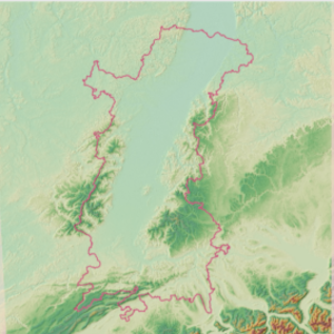
Relief - Modèle numérique de terrain (MNT) du Rhin Supérieur
Relief - Digitale Geländemodell (DGM) des Oberrheins
Relief - Digital Elevation Model (DEM) of the Upper Rhine
Cette donnée décrit le relief à travers une image constituée de pixels faisant 25x25m. Ce modèle numérique de terrain maillé fourni, pour chaque pixel, une valeur d'altitude. La donnée provient d'un découpage sur la région du Rhin Supérieur du produit fourni par le service Copernicus de surveillance des terres (CLMS).
Diese Daten beschreiben das Relief durch ein Bild, das aus 25x25m großen Pixeln besteht. Dieses vermaschte digitale Geländemodell liefert für jeden Pixel einen Höhenwert. Die Daten stammen aus dem Produkt des Copernicus Land Monitoring Service (CLMS), das auf die Oberrheinregion zugeschnitten ist.
This data describes the relief through an image made of pixels measuring 25x25m. This digital terrain model provides, for each pixel, an altitude value. The data comes from a clipping over the Upper Rhine region of the product provided by the Copernicus Land Monitoring Service (CLMS).
Simple
-
Autres appellations ou acronymesAlternativtitelAlternate title
-
MNT
DGM
DEM
-
Datumsangaben (Erstellung)Date (Creation)Date (Création)
- 2021-11-10
-
Datumsangaben (Publikation)Date (Publication)Date (Publication)
- 2021-12-14
-
IdentifikatorCitation identifierIdentificateur
- mnt_dgm
-
BearbeitungsstatusStatusEtat
-
AbgeschlossenCompletedFinalisé
- Point of contact
-
Organisation name Individual name Electronic mail address Role GeoRhena
GeoRhena
GeoRhena
GeoRhena
GeoRhena
GeoRhena
AnsprechpartnerPoint of contactPoint de contactGeoRhena
GeoRhena
GeoRhena
BearbeiterProcessorExécutant
-
ÜberarbeitungsintervallMaintenance and update frequencyFréquence de mise à jour
-
Nicht geplantNot plannedNon planifiée
- Keywords
-
-
Données ouvertes
Open-Data
Open-Data
-
Relief
Relief
Relief
-
- Keywords
-
-
Rhin Supérieur
Oberrhein
Upper Rhine
-
-
GEMET - Concepts, version 2.4
-
-
altitude
Höhe
altitude
-
relief
Relief
relief (land)
-
-
Limitation d'utilisationAnwendungseinschränkungenUse limitation
-
Licence CC BY - © European Union, Copernicus Land Monitoring Service 2018, European Environment Agency (EEA)
Licence CC BY - © European Union, Copernicus Land Monitoring Service 2018, European Environment Agency (EEA)
Licence CC BY - © European Union, Copernicus Land Monitoring Service 2018, European Environment Agency (EEA)
-
ZugriffseinschränkungenAccess constraintsContraintes d'accès
-
Benutzerdeifinierte EinschränkungenOther restrictionsAutres restrictions
-
NutzungseinschränkungenUse constraintsContraintes d'utilisation
-
Benutzerdeifinierte EinschränkungenOther restrictionsAutres restrictions
-
Autres contraintesAndere EinschränkungenOther constraints
-
Pas d'autre limitation
Keine andere Einschränkung
No other limitation
-
Räumliche DarstellungsartSpatial representation typeType de représentation spatiale
-
VektorVectorVecteur
-
MassstabszahlDenominatorDénominateur de l'échelle
- 5000
-
SpracheLanguageLangue de la ressource
- Français
-
ZeichensatzCharacter setEncodage des caractères
-
Utf8UTF8Utf8
-
ThematikTopic categoryCatégorie ISO
-
-
HöhenangabenElevationAltimétrie
-
OberflächenbeschreibungImagery base maps earth coverCarte de référence de la couverture terrestre
-
- Begin date
- 2011-01-01
- End date
- 2011-12-31
))
- Distribution format
-
Name Version Géodonnée au format TIF
GeoDatei im TIF
TIF GeoData
-
- OnLine resource
-
Protocol Linkage Name OGC:WMS
https://geoportal.georhena.eu/geoserver/basemaps/ows?SERVICE=WMS&REQUEST=GetCapabilities mnt_dem
WWW:LINK-1.0-http--link
https://dataspace.copernicus.eu/ Site internet du programme Copernicus
Website des Copernicus-Programms
Copernicus programme website
-
BezugsebeneHierarchy levelNiveau
-
DatenbestandDatasetJeu de données
-
Généralités sur la provenanceErläuterungStatement
-
Découpage réalisée sur le produit EU-DEM v1.1 (programme Copernicus)
Ausschnitt erstellt auf dem Produkt EU-DEM v1.1 (Copernicus Programm)
Trimming performed on the EU-DEM v1.1 product (Copernicus programme)
Metadata
-
MetadatensatzidentifikatorFile identifierIdentifiant de la fiche
- 0dfbcf14-2f1e-4a2d-b186-6c532a00f9f2 XML
-
SpracheMetadata languageLangue
- Français
-
ZeichensatzCharacter setJeu de caractères
-
Utf8UTF8Utf8
-
HierarchieebeneHierarchy levelType de ressource
-
DatenbestandDatasetJeu de données
-
DatumDate stampDate des métadonnées
- 2025-06-18T15:08:38.601463Z
- Metadata standard name
-
ISO 19115:2003/19139
- Metadata standard version
-
1.0
- Metadata author
-
Organisation name Individual name Electronic mail address Role GeoRhena: Système d'Information Géographique du Rhin Supérieur
GeoRhena: Geographische Informationssystem des Oberrheins
GeoRhena: Geographical Information System of the Upper Rhine
VertriebDistributorDistributeur
- Other language
-
Language Character encoding DeutschGermanAllemandUtf8UTF8Utf8EnglischEnglishAnglaisUtf8UTF8Utf8FranzösischFrenchFrançaisUtf8UTF8Utf8
Overviews
Spatial extent
Provided by
