 Catalogue DataGrandEst
Relief - Digital Elevation Model (DEM) of the Upper Rhine
This data describes the relief through an image made of pixels measuring 25x25m. This digital terrain model provides, for each pixel, an altitude value. The data comes from a clipping over the Upper Rhine region of the product provided by the Copernicus Land Monitoring Service (CLMS).
Simple
- Alternate title
-
DEM
- Date (Creation)
- 2021-11-10
- Date (Publication)
- 2021-12-14
- Citation identifier
- mnt_dgm
- Status
- Completed
- Point of contact
-
Organisation name Individual name Electronic mail address Role GeoRhena
GeoRhena
Point of contact GeoRhena
Processor
- Maintenance and update frequency
- Not planned
- Keywords
-
-
Open-Data
-
Relief
-
- Keywords
-
-
Upper Rhine
-
-
GEMET - Concepts, version 2.4
-
-
altitude
-
relief (land)
-
- Use limitation
-
Licence CC BY - © European Union, Copernicus Land Monitoring Service 2018, European Environment Agency (EEA)
- Access constraints
- Other restrictions
- Use constraints
- Other restrictions
- Other constraints
-
No other limitation
- Spatial representation type
- Vector
- Denominator
- 5000
- Language
- Français
- Character set
- UTF8
- Topic category
-
- Elevation
- Imagery base maps earth cover
- Begin date
- 2011-01-01
- End date
- 2011-12-31
N
S
E
W
))
- Distribution format
-
Name Version TIF GeoData
-
- OnLine resource
-
Protocol Linkage Name OGC:WMS
https://geoportal.georhena.eu/geoserver/basemaps/ows?SERVICE=WMS&REQUEST=GetCapabilities mnt_dem
WWW:LINK-1.0-http--link
https://dataspace.copernicus.eu/ Copernicus programme website
- Hierarchy level
- Dataset
- Statement
-
Trimming performed on the EU-DEM v1.1 product (Copernicus programme)
Metadata
- File identifier
- 0dfbcf14-2f1e-4a2d-b186-6c532a00f9f2 XML
- Metadata language
- Français
- Character set
- UTF8
- Hierarchy level
- Dataset
- Date stamp
- 2025-06-18T15:08:38.601463Z
- Metadata standard name
-
ISO 19115:2003/19139
- Metadata standard version
-
1.0
- Metadata author
-
Organisation name Individual name Electronic mail address Role GeoRhena: Geographical Information System of the Upper Rhine
Distributor
- Other language
-
Language Character encoding German UTF8 English UTF8 French UTF8
Overviews
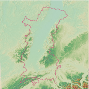
Spatial extent
N
S
E
W
Provided by

Associated resources
Not available