 Catalogue DataGrandEst
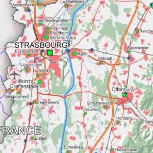
Strasbourg-Ortenau Eurodistrict Transport/Land Use - 2016
This map represents the land use and the different transport infrastructures on the territory of the Strasbourg-Ortenau Eurodistrict.
Simple
- Date (Creation)
- 2016-03-01
- Date (Publication)
- 2016-03-01
- Citation identifier
- 04_2016_0230
- Status
- Completed
- Point of contact
-
Organisation name Individual name Electronic mail address Role GeoRhena
GeoRhena
Processor
- Maintenance and update frequency
- Not planned
- Keywords
-
-
Map
-
- Keywords
-
-
Upper Rhine
-
-
GEMET - Concepts, version 2.4
-
-
geography
-
land occupation
-
transportation
-
- Use limitation
-
Licence CC BY
- Access constraints
- Other restrictions
- Use constraints
- Other restrictions
- Other constraints
-
No other limitation
- Denominator
- 100000
- Language
- Français
- Character set
- UTF8
- Topic category
-
- Transportation
- Imagery base maps earth cover
- Begin date
- 2016-01-01
- End date
- 2016-12-31
N
S
E
W
))
- Distribution format
-
Name Version PDF Map
-
- OnLine resource
-
Protocol Linkage Name WWW:DOWNLOAD-1.0-http--download
https://www.georhena.eu/sites/default/files/Cartes/04_2016_0230.pdf Pdf Download
Metadata
- File identifier
- 42735c8d-bd7c-4437-bd1f-4a121a1e7a16 XML
- Metadata language
- Français
- Character set
- UTF8
- Hierarchy level
- Static map
- Hierarchy level name
-
Carte statique
- Date stamp
- 2022-09-20T15:21:14.409054Z
- Metadata standard name
-
ISO 19115:2003/19139
- Metadata standard version
-
1.0
- Metadata author
-
Organisation name Individual name Electronic mail address Role GeoRhena: Geographical Information System of the Upper Rhine
Author
- Other language
-
Language Character encoding German UTF8 English UTF8 French UTF8
Overviews
04_2016_0230.png
Spatial extent
N
S
E
W
Provided by

Associated resources
Not available