 Catalogue DataGrandEst
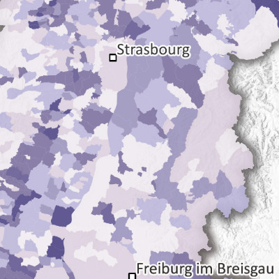
Greenhouse gas emissions per capita by municipality and county in the Upper Rhine region (2021)
Produced as part of the Interreg Upper Rhine Atmo-Rhena PLUS project, this map shows greenhouse gas emissions per square kilometer by municipality and canton in the Upper Rhine region in 2021.
Limiting greenhouse gas emissions is the main lever for taking action against the rise in the planet's average temperature, which is causing climate change. The GHG emissions in this inventory correspond to the “direct” emissions of a territory, i.e., those emitted within the territory itself. Emissions generated outside the territory during the production, for example, of goods or services used within the territory are called “indirect” emissions and are not included in this inventory.
This inventory takes into account the three main greenhouse gases covered by the Kyoto Protocol: carbon dioxide (CO2), methane (CH4), and nitrous oxide (N2O). The various greenhouse gas emissions are converted and added together in CO2 equivalents (ktCO2eq) using their Global Warming Potential (GWP). The GWP used here is calculated according to the method set out in the IPCC's 5th Assessment Report published in 2013. These total greenhouse gas emissions are also expressed in CO2 equivalents using the unit ktCO2eq.
The map of greenhouse gas emissions for the Upper Rhine, all sectors combined, shows that most of the areas affected are populated and/or have heavy road traffic (cities, the Vosges and Black Forest valleys, the Rhine Rift Valley), are industrial, or are used for electricity generation.
The static map in PDF format is available at the municipal level (France and Germany) and at the canton level (Switzerland). The data is accessible as open data only at the EPCI, Kreis and canton levels.
Simple
- Date (Creation)
- 2025-05-06
- Date (Publication)
- 2025-11-06
- Citation identifier
- AtmoRhenaPlus_GES_habitant
- Status
- Completed
- Point of contact
-
Organisation name Individual name Electronic mail address Role GeoRhena
Point of contact ATMO Grand Est
Custodian Landesanstalt für Umwelt Baden-Württemberg (LUBW)
Custodian Lufthygieneamt beider Basel
Custodian Landesamt für Umwelt Rheinland-Pfalz
Custodian Office de l'environnement - République et Canton du Jura
Custodian Departement Bau, Verkehr und Umwelt - Kanton Aargau
Custodian
- Maintenance and update frequency
- Not planned
- Theme
-
-
Upper Rhine
-
Crossborder
-
- Use limitation
-
CC-BY Licence ©OpenStreetMap contributors ©GeoRhena
- Access constraints
- Other restrictions
- Use constraints
- Other restrictions
- Other constraints
-
No other limitation
- Spatial representation type
- Vector
- Denominator
- 50000
- Language
- Français
- Language
- Deutsch
- Language
- English
- Character set
- UTF8
- Topic category
-
- Environment
- Health
- Begin date
- 2020-01-01
- End date
- 2021-12-31
))
Digital transfer options
- OnLine resource
-
Protocol Linkage Name OGC:WMS
https://portailsig.atmo-grandest.eu/server/services/Flux_Atmorhenaplus/atmo_rhena_plus_emi_ges_thg_hab_einwohner/MapServer/WMSServer 0
OGC:WFS
https://portailsig.atmo-grandest.eu/server/services/Flux_Atmorhenaplus/atmo_rhena_plus_emi_ges_thg_hab_einwohner/MapServer/WFSServer Greenhouse gas emissions (GWP 2013) per capita
WWW:LINK-1.0-http--link
https://atmo-rhena.eu/ Upper Rhine Air Quality Portal
WWW:DOWNLOAD-1.0-http--download
https://www.georhena.eu/sites/default/files/Cartes/GES_hab_A6.pdf Greenhouse gas emissions (GWP 2013) per capita
OnLine resource
Digital transfer options
- OnLine resource
-
Protocol Linkage Name WWW:LINK-1.0-http--related
https://plateforme.atmo-grandest.eu/projets/atmo-rhena-plus.php Upper Rhine Air-Climate-Energy Dashboard
- Hierarchy level
- staticMap
- Statement
-
Collection of estimated final energy consumption for the Grand Est region (ATMO Grand Est), Baden-Württemberg (Landesanstalt für Umwelt Baden-Württemberg – LUBW and Statistisches Landesamt Baden-Württemberg - StaLa), the cantons of Basel-Stadt and Basel-Landschaft (Lufthygienamt Beider Basel – LHA), Rhineland-Palatinate (Landesamt für Umwelt Rheinland-Pfalz – LfU and Energieagentur Rheinland-Pfalz/Energieatlas - EA RLP) and the canton of Jura (Office de l'environnement - ENV Jura). Data from the cantons of Jura, Aargau, and Solothurn have been grouped by canton.
Metadata
- File identifier
- 005c2ee1-0294-4702-b7f6-40fd7bd05618 XML
- Metadata language
- Français
- Character set
- UTF8
- Hierarchy level
- staticMap
- Date stamp
- 2025-11-06T10:41:56.268725Z
- Metadata standard name
-
ISO 19115:2003/19139
- Metadata standard version
-
1.0
- Metadata author
-
Organisation name Individual name Electronic mail address Role GeoRhena: Geographical Information System of the Upper Rhine
Point of contact
- Other language
-
Language Character encoding English UTF8 German UTF8 French UTF8
)))
