Catalogue DataGrandEst
Corine Land Cover 2018
Corine Land Cover 2018
Corine Land Cover 2018
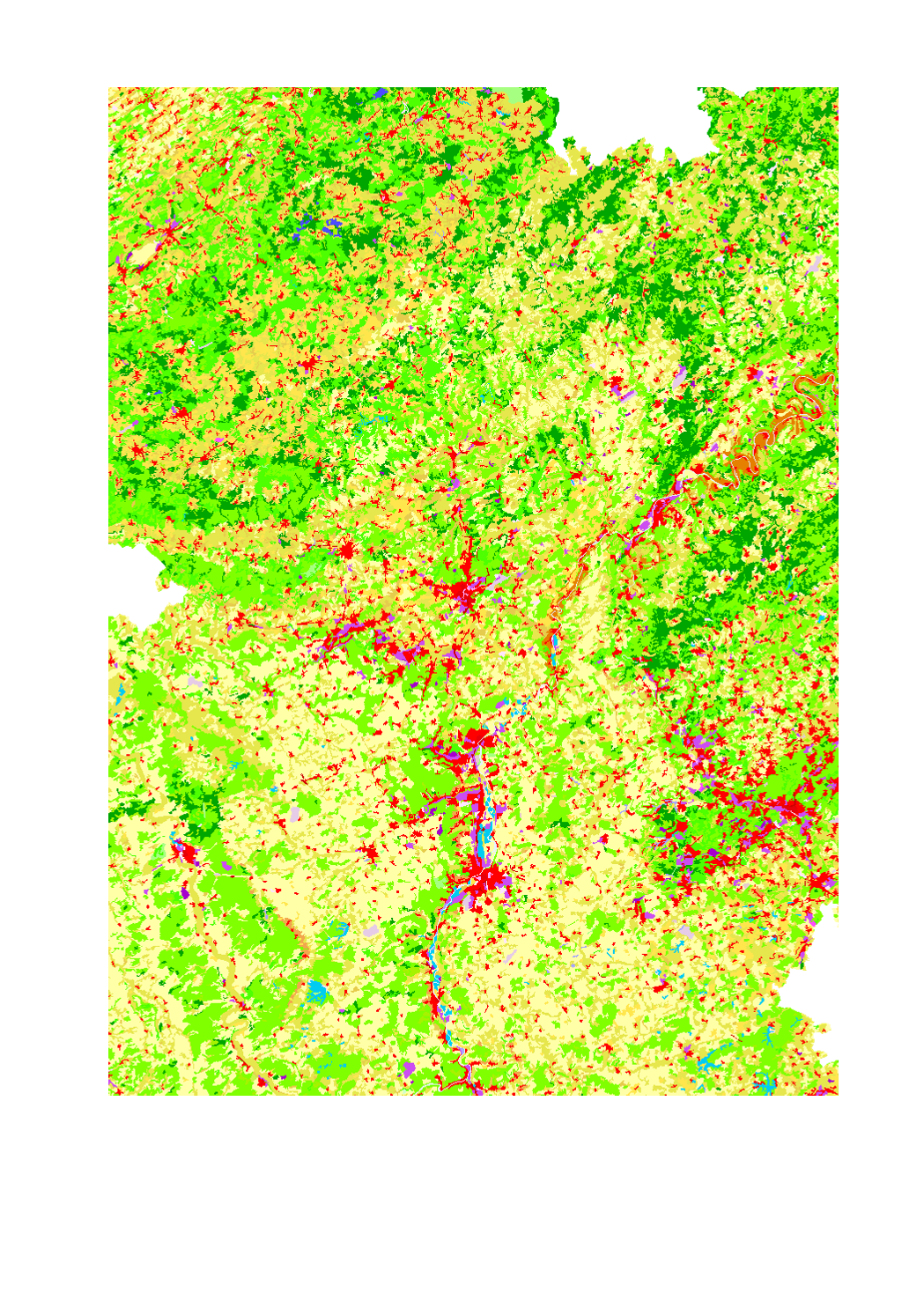
Occupation du sol dans la Grande Région selon Corine Land Cover 2018
- Source: European Environment Agency - Corine Land Cover (CLC) 2018 v20
Land use in the Greater Region according to Corine Land Cover 201
- Source: European Environment Agency - Corine Land Cover (CLC) 2018 v20
Landnutzung in der Großregion nach Corine Land Cover 2018
- Quelle: European Environment Agency - Corine Land Cover (CLC) 2018 v20
Simple
-
Date (Creation)Datumsangaben (Erstellung)Date (Création)
- 2019-08-08T00:00:00
-
Citation identifierIdentifikatorIdentificateur
- / 0ac32e4e-f97a-45cc-9736-bc21121842d1
-
Presentation formPräsentationsformForme de la présentation
-
Digital mapDigitale KarteCarte numérique
-
StatusBearbeitungsstatusEtat
-
CompletedAbgeschlossenFinalisé
- Point of contact
-
Organisation name Individual name Electronic mail address Role SIG-GR - Ministère de l'Energie et de l'Aménagement du territoire - Département de l'aménagement du territoire
Thierry Hengen
AuthorAutorAuteur
-
Maintenance and update frequencyÜberarbeitungsintervallFréquence de mise à jour
-
ContinualKontinuierlichContinue
- Keywords
-
-
Sol, occupation, Corine
land, use, Corine
Boden, Nutzung, Corine
-
-
Entités dans la Grande Région
-
-
Grande Région
Greater Region
Großregion
-
-
gis-gr.eu themes
-
-
Occupation des sols
Land cover
Landnutzung
-
-
gis-gr.eu structure
-
-
Occupation des sols>Corine Land Cover
Land cover>Corine Land Cover
Landnutzung>Corine Land Cover
-
- Keywords
-
-
gis-gr.eu
gis-gr.eu
gis-gr.eu
-
-
Access constraintsZugriffseinschränkungenContraintes d'accès
-
Other restrictionsBenutzerdefinierte EinschränkungenAutres restrictions
-
Spatial representation typeRäumliche DarstellungsartType de représentation spatiale
-
VectorVektorVecteur
-
DenominatorMaßstabszahlDénominateur de l'échelle
- 100000
-
LanguageSpracheLangue de la ressource
- English
-
LanguageSpracheLangue de la ressource
- Deutsch
-
LanguageSpracheLangue de la ressource
- Français
-
Character setZeichensatzEncodage des caractères
-
UTF8Utf8Utf8
-
Topic categoryISO-ThematikCatégorie ISO
-
-
Imagery base maps earth coverOberflächenbeschreibungCarte de référence de la couverture terrestre
-
))
-
Reference system identifierIdentifikator des ReferenzsystemsNom du système de référence
- EPSG / http://www.opengis.net/def/crs/EPSG/0/3857
- Distribution format
-
Name Version PDF
JPEG
SHAPE
Digital transfer options
Digitale Transferoptionen
Options de transfert numérique
- OnLine resource
-
Protocol Linkage Name WWW:LINK-1.0-http--samples
https://map.gis-gr.eu/theme/occupation_des_sols?version=3&zoom=8&X=667917&Y=6394482&lang=en&layers=1872&opacities=1&bgLayer=basemap_2015_global Carte interactive
Interactive map
Interaktive Karte
WWW:LINK-1.0-http--link
https://data.public.lu/en/datasets/corine-land-cover-2018 Open data
OGC:WMS-1.3.0-http-get-map
https://ws.geoportail.lu/wss/service/GR_land_cover_WMS/guest Corine_land_cover_2018
OGC:WFS
https://ws.geoportail.lu/wss/service/GR_land_cover_WFS/guest land_cover:Corine_land_cover_2018
Metadata
-
File identifierMetadatensatzidentifikatorIdentifiant de la fiche
- 0ac32e4e-f97a-45cc-9736-bc21121842d1 XML
-
Metadata languageSpracheLangue
- Français
-
Character setZeichensatzJeu de caractères
-
UTF8Utf8Utf8
-
Hierarchy levelHierarchieebeneType de ressource
-
DatasetDatenbestandJeu de données
- Hierarchy level name
-
dataset
-
Date stampDatumDate des métadonnées
- 2025-01-10T12:41:39
- Metadata standard name
-
ISO 19115:2003/19139
- Metadata standard version
-
1.0
- Metadata author
-
Organisation name Individual name Electronic mail address Role SIG-GR - Ministère de l'Energie et de l'Aménagement du territoire - Département de l'aménagement du territoire
Thierry Hengen
Point of contactAnsprechpartnerPoint de contact
- Other language
-
Language Character encoding EnglishEnglischAnglaisUTF8Utf8Utf8GermanDeutschAllemandUTF8Utf8Utf8FrenchFranzösischFrançaisUTF8Utf8Utf8
)))