 Catalogue DataGrandEst
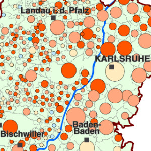
Evolution of the population over 75 years of age between 1999 and 2006 by Upper Rhine municipalities
This map shows the evolution of the population aged over 75 between 1999 and 2006 in the Upper Rhine area.
Simple
- Date (Creation)
- 2010-11-01
- Date (Publication)
- 2010-11-01
- Citation identifier
- 05_2010_0099
- Status
- Completed
- Point of contact
-
Organisation name Individual name Electronic mail address Role GeoRhena
GeoRhena
Processor
- Maintenance and update frequency
- Not planned
- Keywords
-
-
Map
-
- Keywords
-
-
Upper Rhine
-
-
GEMET - Concepts, version 2.4
-
-
demography
-
inhabitant
-
- Use limitation
-
Licence CC BY
- Access constraints
- Other restrictions
- Use constraints
- Other restrictions
- Other constraints
-
No other limitation
- Denominator
- 100000
- Language
- Français
- Character set
- UTF8
- Topic category
-
- Society
- Begin date
- 1999-01-01
- End date
- 2006-12-31
N
S
E
W
))
- Distribution format
-
Name Version PDF Map
-
Digital transfer options
- OnLine resource
-
Protocol Linkage Name WWW:DOWNLOAD-1.0-http--download
https://www.georhena.eu/sites/default/files/Cartes/05_2010_0102.pdf Pdf Download
Metadata
- File identifier
- 0f058260-3591-46b2-9612-b3f8d301c847 XML
- Metadata language
- Français
- Character set
- UTF8
- Hierarchy level
- staticMap
- Hierarchy level name
-
Carte statique
- Date stamp
- 2022-10-20T09:08:11.79613Z
- Metadata standard name
-
ISO 19115:2003/19139
- Metadata standard version
-
1.0
- Metadata author
-
Organisation name Individual name Electronic mail address Role GeoRhena: Geographical Information System of the Upper Rhine
Author
- Other language
-
Language Character encoding German UTF8 English UTF8 French UTF8
)))
