 Catalogue DataGrandEst
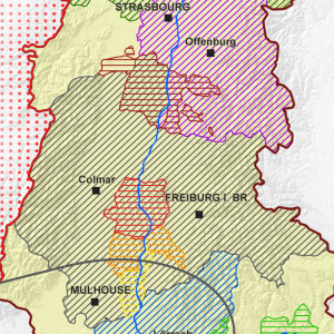
Territoires de coopération transfrontalière du Rhin Supérieur - 2015
Gebiete der grenzüberschreitenden Zusammenarbeit am Oberrhein - 2015
Cross-border cooperation territories of the Upper Rhine - 2015
Cette carte décrit les différents territoires de coopération existants sur le Rhin Supérieur.
Diese Karte beschreibt die verschiedenen Kooperationsgebiete, die am Oberrhein existieren.
This map describes the different cooperation territories in the Upper Rhine.
Simple
-
Datumsangaben (Erstellung)Date (Creation)Date (Création)
- 2015-04-01
-
Datumsangaben (Publikation)Date (Publication)Date (Publication)
- 2015-04-01
-
Datumsangaben (Überarbeitung)Date (Revision)Date (Révision)
- 2017-01-01
-
IdentifikatorCitation identifierIdentificateur
- 04_2015_222
-
BearbeitungsstatusStatusEtat
-
AbgeschlossenCompletedFinalisé
- Point of contact
-
Organisation name Individual name Electronic mail address Role GeoRhena
GeoRhena
GeoRhena
GeoRhena
BearbeiterProcessorExécutant
-
ÜberarbeitungsintervallMaintenance and update frequencyFréquence de mise à jour
-
Nicht geplantNot plannedNon planifiée
- Keywords
-
-
Carte
Karte
Map
-
- Keywords
-
-
Rhin Supérieur
Oberrhein
Upper Rhine
-
-
GEMET - Concepts, version 2.4
-
-
limite administrative
Verwaltungsgrenze
administrative boundary
-
géographie
Geographie
geography
-
politique de coopération
Kooperationspolitik
co-operation policy
-
-
Limitation d'utilisationAnwendungseinschränkungenUse limitation
-
Licence CC BY
Licence CC BY
Licence CC BY
-
ZugriffseinschränkungenAccess constraintsContraintes d'accès
-
Benutzerdefinierte EinschränkungenOther restrictionsAutres restrictions
-
NutzungseinschränkungenUse constraintsContraintes d'utilisation
-
Benutzerdefinierte EinschränkungenOther restrictionsAutres restrictions
-
Autres contraintesAndere EinschränkungenOther constraints
-
Pas d'autre limitation
Keine andere Einschränkung
No other limitation
-
MaßstabszahlDenominatorDénominateur de l'échelle
- 100000
-
SpracheLanguageLangue de la ressource
- Français
-
ZeichensatzCharacter setEncodage des caractères
-
Utf8UTF8Utf8
-
ISO-ThematikTopic categoryCatégorie ISO
-
-
GrenzenBoundariesLimites politiques et administratives
-
- Begin date
- 2017-01-01
- End date
- 2017-12-31
))
- Distribution format
-
Name Version Carte au format PDF
Karte in PDF
PDF Map
-
Digitale Transferoptionen
Digital transfer options
Options de transfert numérique
- OnLine resource
-
Protocol Linkage Name WWW:DOWNLOAD-1.0-http--download
https://www.georhena.eu/sites/default/files/Cartes/04_2015_222.pdf Téléchargement du Pdf
Pdf herunterladen
Pdf Download
Metadata
-
MetadatensatzidentifikatorFile identifierIdentifiant de la fiche
- 16979fa9-58d9-4858-8e7f-faec6aa3e1ed XML
-
SpracheMetadata languageLangue
- Français
-
ZeichensatzCharacter setJeu de caractères
-
Utf8UTF8Utf8
-
HierarchieebeneHierarchy levelType de ressource
-
staticMapstaticMapstaticMap
- Hierarchy level name
-
Carte statique
-
DatumDate stampDate des métadonnées
- 2022-09-23T09:50:24.849411Z
- Metadata standard name
-
ISO 19115:2003/19139
- Metadata standard version
-
1.0
- Metadata author
-
Organisation name Individual name Electronic mail address Role GeoRhena: Système d'Information Géographique du Rhin Supérieur
GeoRhena: Geographische Informationssystem des Oberrheins
GeoRhena: Geographical Information System of the Upper Rhine
AutorAuthorAuteur
- Other language
-
Language Character encoding DeutschGermanAllemandUtf8UTF8Utf8EnglischEnglishAnglaisUtf8UTF8Utf8FranzösischFrenchFrançaisUtf8UTF8Utf8
Overviews
Spatial extent
)))
Provided by
