Catalogue DataGrandEst
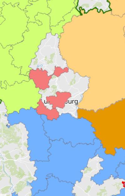
Documents d’aménagement des territoires infrarégionaux de la Grande Région et du Rhin Supérieur 2024
Subregional spatial planning documents in the Greater Region and the Upper Rhine 2024
Regionale Raumplanungsdokumente der Großregion und des Oberrheins 2024
- Documents d’aménagement des territoires infrarégionaux de la Grande Région et du Rhin Supérieur 2024
- Sources: GeoRhena, MDI Rheinland-Pfalz, MIBS Saarland, Ministerium der Deutschsprachigen Gemeinschaft, MLOGAT-DATer Luxembourg, Région Grand Est, Service public de Wallonie, Verband Rhein-Neckar 2024. Harmonisation: SIG-GR 2024
- Subregional spatial planning documents in the Greater Region and the Upper Rhine 2024
- Sources: GeoRhena, MDI Rheinland-Pfalz, MIBS Saarland, Ministerium der Deutschsprachigen Gemeinschaft, MLOGAT-DATer Luxembourg, Région Grand Est, Service public de Wallonie, Verband Rhein-Neckar 2024. Harmonization: GIS-GR 2024
- Regionale Raumplanungsdokumente der Großregion und des Oberrheins 2024
- Quellen: GeoRhena, MDI Rheinland-Pfalz, MIBS Saarland, Ministerium der Deutschsprachigen Gemeinschaft, MLOGAT-DATer Luxembourg, Région Grand Est, Service public de Wallonie, Verband Rhein-Neckar 2024. Harmonisierung: GIS-GR 2024
Simple
-
Date (Creation)Datumsangaben (Erstellung)Date (Création)
- 2024-06-05T00:00:00
-
Citation identifierIdentifikatorIdentificateur
- / 936e8b01-d0b6-4a58-a245-9b0c39364faa
-
Presentation formPräsentationsformForme de la présentation
-
Digital mapDigitale KarteCarte numérique
-
StatusBearbeitungsstatusEtat
-
CompletedAbgeschlossenFinalisé
- Point of contact
-
Organisation name Individual name Electronic mail address Role SIG-GR - Ministère du Logement et de l'Aménagement du territoire - Département de l'aménagement du territoire
Thierry Hengen
AuthorAutorAuteur
-
Maintenance and update frequencyÜberarbeitungsintervallFréquence de mise à jour
-
As neededBei BedarfLorsque nécessaire
- Keywords
-
-
aménagement du territoire, infrarégional
Spatial planning, subregional
Raumplanung, regional
-
-
Entités dans la Grande Région
-
-
Grande Région
Greater Region
Großregion
-
-
gis-gr.eu themes
-
-
Aménagement du territoire
Spatial planning
Raumplanung
-
-
gis-gr.eu structure
-
-
Aménagement du territoire>Documents d’aménagement du territoire
Spatial planning>Spatial planning documents
Raumplanung>Raumplanungsdokumente
-
- Keywords
-
-
gis-gr.eu
gis-gr.eu
gis-gr.eu
-
-
Access constraintsZugriffseinschränkungenContraintes d'accès
-
Other restrictionsBenutzerdefinierte EinschränkungenAutres restrictions
-
Spatial representation typeRäumliche DarstellungsartType de représentation spatiale
-
VectorVektorVecteur
-
DenominatorMaßstabszahlDénominateur de l'échelle
- 0
-
LanguageSpracheLangue de la ressource
- English
-
LanguageSpracheLangue de la ressource
- Français
-
LanguageSpracheLangue de la ressource
- Deutsch
-
Character setZeichensatzEncodage des caractères
-
UTF8Utf8Utf8
-
Topic categoryISO-ThematikCatégorie ISO
-
-
Planning cadastrePlanungsunterlagen, KatasterCadastre, aménagement
-
))
-
Reference system identifierIdentifikator des ReferenzsystemsNom du système de référence
- EPSG / http://www.opengis.net/def/crs/EPSG/0/3857
- Distribution format
-
Name Version PDF
SHAPE
JPEG
Digital transfer options
Digitale Transferoptionen
Options de transfert numérique
- OnLine resource
-
Protocol Linkage Name WWW:LINK-1.0-http--partners
https://geoportal.georhena.eu/mviewer/?config=apps/raumordnung.xml Carte interactive GeoRhena - version DE
Interactive map GeoRhena - DE version
Interaktive Karte GeoRhena - Version DE
WWW:LINK-1.0-http--partners
https://geoportal.georhena.eu/mviewer/?config=apps/amenagement.xml# Carte interactive GeoRhena - version FR
Interactive map GeoRhena - FR version
Interaktive Karte GeoRhena - version FR
WWW:LINK-1.0-http--samples
http://g-o.lu/gg/vIOh Carte interactive SIG-GR
Interactive map GIS-GR
Interaktive Karte GIS-GR
WWW:LINK-1.0-http--related
https://www.sig-gr.eu/fr/cartes-thematiques/amenagement-territoire/documents-amenagement-territoire/2024/documents-at-intercommunaux-gr-rs-2024.html Carte statique commentée - version FR
Commented static map - FR version
Kommentierte statische Karte - Version FR
WWW:LINK-1.0-http--related
https://www.sig-gr.eu/de/cartes-thematiques/amenagement-territoire/documents-amenagement-territoire/2024/documents-at-intercommunaux-gr-rs-2024.html Carte statique commentée - version DE
Commented static map - DE version
Kommentierte statische Karte - Version DE
WWW:LINK-1.0-http--link
https://data.public.lu/fr/datasets/subregional-spatial-planning-documents-in-the-greater-region-and-the-upper-rhine-2024/ Open data
OGC:WMS-1.3.0-http-get-capabilities
https://ws.geoportail.lu/wss/service/GR_Spatial_planning_WMS/guest Perimeter_GR_UR
OGC:WMS-1.3.0-http-get-capabilities
https://ws.geoportail.lu/wss/service/GR_Spatial_planning_WMS/guest Common_border_GR_UR
OGC:WMS-1.3.0-http-get-capabilities
https://ws.geoportail.lu/wss/service/GR_Spatial_planning_WMS/guest Subregional_strategies_2024
OGC:WFS
https://ws.geoportail.lu/wss/service/GR_Spatial_planning_WFS/guest Spatial_planning:Common_border_GR_UR
OGC:WFS
https://ws.geoportail.lu/wss/service/GR_Spatial_planning_WFS/guest Spatial_planning:Perimeter_GR_UR
OGC:WFS
https://ws.geoportail.lu/wss/service/GR_Spatial_planning_WFS/guest Spatial_planning:Subregional_strategies_2024
Metadata
-
File identifierMetadatensatzidentifikatorIdentifiant de la fiche
- 26d0b355-184e-4dc6-8984-8094215e8dac XML
-
Metadata languageSpracheLangue
- Français
-
Character setZeichensatzJeu de caractères
-
UTF8Utf8Utf8
-
Hierarchy levelHierarchieebeneType de ressource
-
DatasetDatenbestandJeu de données
- Hierarchy level name
-
dataset
-
Date stampDatumDate des métadonnées
- 2024-11-19T11:10:18
- Metadata standard name
-
ISO 19115:2003/19139
- Metadata standard version
-
1.0
- Metadata author
-
Organisation name Individual name Electronic mail address Role SIG-GR - Ministère du Logement et de l'Aménagement du territoire - Département de l'aménagement du territoire
Thierry Hengen
Point of contactAnsprechpartnerPoint de contact
- Other language
-
Language Character encoding EnglishEnglischAnglaisUTF8Utf8Utf8GermanDeutschAllemandUTF8Utf8Utf8FrenchFranzösischFrançaisUTF8Utf8Utf8
)))