Catalogue DataGrandEst
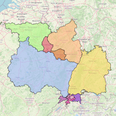
Interactive map - Planning documents for the Upper Rhine and Greater Region
Interactive map showing the different boundaries of spatial planning documents in the Upper Rhine and Greater Region.
Simple
- Date (Creation)
- 2024-03-01
- Date (Publication)
- 2024-03-01T08:33:49
- Date (Revision)
- 2024-06-01
- Presentation form
- Digital map
- Status
- Completed
- Point of contact
-
Organisation name Individual name Electronic mail address Role GeoRhena
Author
- Keywords
-
-
Mviewer
-
Spatial planning
-
- Language
- Français
- Reference system identifier
- EPSG:3857
- Distribution format
-
Name Version OGC:OWS-C
Digital transfer options
- OnLine resource
-
Protocol Linkage Name WWW:LINK-1.0-http--related https://geoportal.georhena.eu/mviewer/?config=apps/amenagement.xml# Spatial planning documents for the Upper Rhine and Greater Region - French version
WWW:LINK-1.0-http--related
https://geoportal.georhena.eu/mviewer/?config=apps/raumordnung.xml Spatial planning documents for the Upper Rhine and Greater Region - German version
Metadata
- File identifier
- 270710a6-4ab6-4b79-8b79-fc96c0151767 XML
- Metadata language
-
fre
- Character set
- UTF8
- Hierarchy level
- interactiveMap
- Hierarchy level name
-
1.0
- Date stamp
- 2024-06-10T14:38:54.999027Z
- Metadata standard name
-
ISO 19115:2003/19139
- Metadata standard version
-
1.0
- Metadata author
-
Organisation name Individual name Electronic mail address Role GeoRhena
Author
- Other language
-
Language Character encoding German UTF8 English UTF8 French UTF8