• Catalogue DataGrandEst
  •   Search
  •   Map

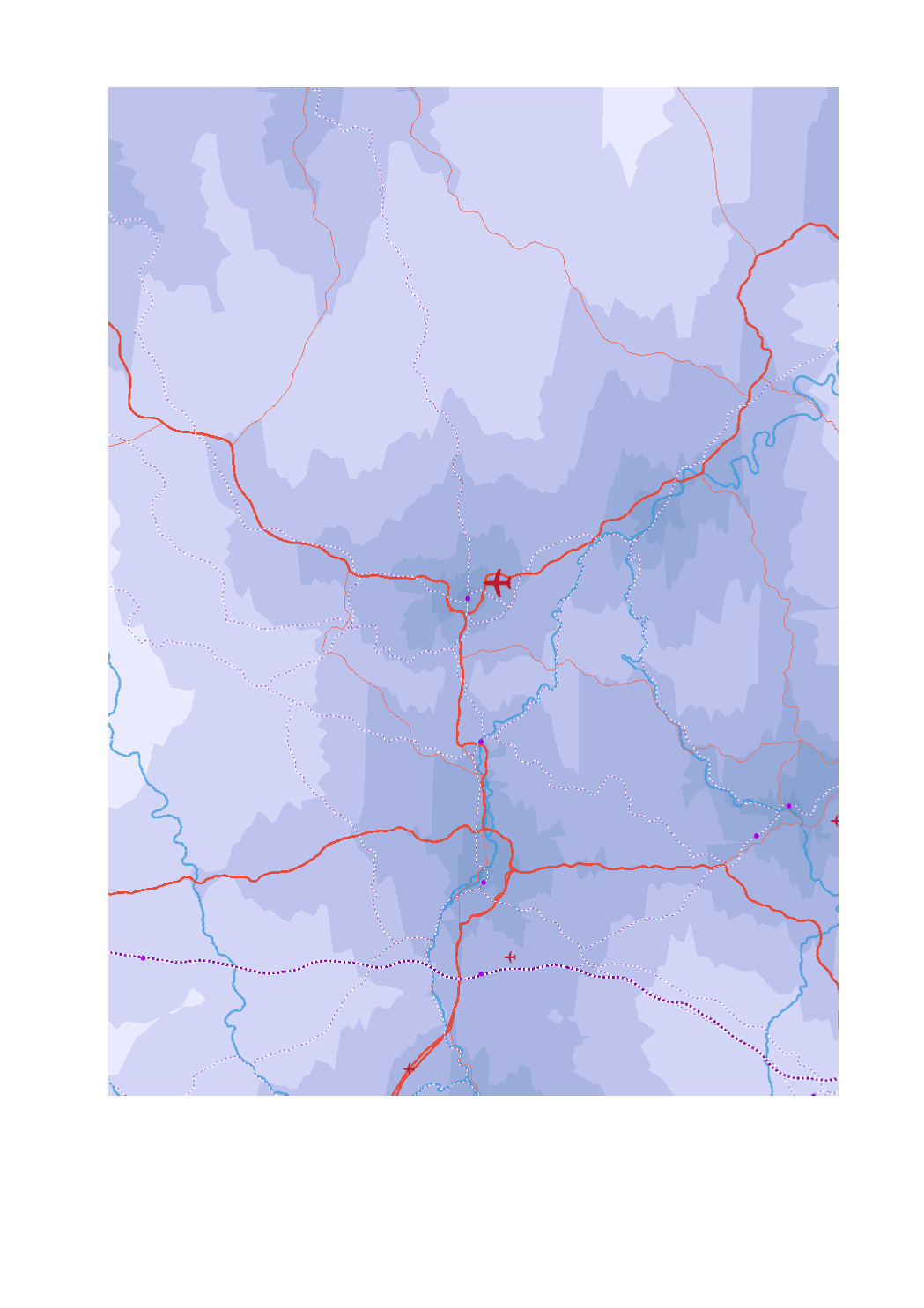
Driving times to major centres at peak times in 2018

- Airport passengers 2017

- Trimodal hubs rail-road-water

- Ports TEN-T

- Airport passengers 2017

- High-speed railway lines

- Railway lines TEN-T

- Main roads (core network TEN-T)

- Secondary roads (comprehensive network TEN-T)

- Navigable waterways

- Maritime links

- Driving times to major centres at peak times in minutes (isochrones)


- Sources: GISCO 2017; SIG-GR / GIS-GR 2017; European Environment Agency 2012; OSM 2017; European Commission 2017; EUROSTAT 2018. Harmonization: CREAT-UCL 2018.

Simple

Date (Creation)
2019-08-05T00:00:00
Citation identifier
/ 2838b198-44b6-4f0f-b9d9-bf4924244766
Presentation form
Digital map
Status
Completed
Point of contact
Organisation name Individual name Electronic mail address Role

SIG-GR - Ministère de l'Energie et de l'Aménagement du territoire - Département de l'aménagement du territoire

Thierry Hengen

thierry.hengen@mat.etat.lu

Author
Maintenance and update frequency
As needed
Keywords
  • accessibility, major centres, transport, supraregional

Entités dans la Grande Région

  • Greater Region

gis-gr.eu themes

  • Transport

gis-gr.eu structure

  • Transport> Accessibility of the major centres

Keywords
  • gis-gr.eu

Access constraints
Other restrictions
Spatial representation type
Vector
Denominator
250000
Language
Deutsch
Language
Français
Language
English
Character set
UTF8
Topic category
  • Transportation
N
S
E
W
thumbnail


Reference system identifier
EPSG / http://www.opengis.net/def/crs/EPSG/0/3857
Distribution format
Name Version

JPEG

SHAPE

PDF

Digital transfer options

OnLine resource
Protocol Linkage Name

WWW:LINK-1.0-http--samples

https://map.gis-gr.eu/theme/transport?version=3&zoom=8&X=667917&Y=6394482&lang=en&layers=1868&opacities=1&bgLayer=basemap_2015_global

Interactive map

WWW:LINK-1.0-http--link

https://data.public.lu/en/datasets/driving-times-to-major-centres-at-peak-times-in-2018

Open data

OGC:WMS-1.3.0-http-get-map

https://ws.geoportail.lu/wss/service/GR_Accessibility_major_centres_WMS/guest

Airport_passengers_2017

OGC:WMS-1.3.0-http-get-map

https://ws.geoportail.lu/wss/service/GR_Accessibility_major_centres_WMS/guest

High_speed_rail_2018

OGC:WMS-1.3.0-http-get-map

https://ws.geoportail.lu/wss/service/GR_Accessibility_major_centres_WMS/guest

Isochrones_driving_times_major_centres_2018

OGC:WMS-1.3.0-http-get-map

https://ws.geoportail.lu/wss/service/GR_Accessibility_major_centres_WMS/guest

Maritime_links_2018

OGC:WMS-1.3.0-http-get-map

https://ws.geoportail.lu/wss/service/GR_Accessibility_major_centres_WMS/guest

Navigable_waterways_2018

OGC:WMS-1.3.0-http-get-map

https://ws.geoportail.lu/wss/service/GR_Accessibility_major_centres_WMS/guest

Railway_TENtec_2018

OGC:WMS-1.3.0-http-get-map

https://ws.geoportail.lu/wss/service/GR_Accessibility_major_centres_WMS/guest

Road_core_TENtec_2018

OGC:WMS-1.3.0-http-get-map

https://ws.geoportail.lu/wss/service/GR_Accessibility_major_centres_WMS/guest

Stops_high_speed_train_lines_2018

OGC:WFS

https://ws.geoportail.lu/wss/service/GR_Accessibility_major_centres_WFS/guest

Accessibility_major_centres:High_speed_rail_2018

OGC:WFS

https://ws.geoportail.lu/wss/service/GR_Accessibility_major_centres_WFS/guest

Accessibility_major_centres:Airport_passengers_2017

OGC:WFS

https://ws.geoportail.lu/wss/service/GR_Accessibility_major_centres_WFS/guest

Accessibility_major_centres:Isochrones_driving_times_major_centres_2018

OGC:WFS

https://ws.geoportail.lu/wss/service/GR_Accessibility_major_centres_WFS/guest

Accessibility_major_centres:Maritime_links_2018

OGC:WFS

https://ws.geoportail.lu/wss/service/GR_Accessibility_major_centres_WFS/guest

Accessibility_major_centres:Navigable_waterways_2018

OGC:WFS

https://ws.geoportail.lu/wss/service/GR_Accessibility_major_centres_WFS/guest

Accessibility_major_centres:Railway_TENtec_2018

OGC:WFS

https://ws.geoportail.lu/wss/service/GR_Accessibility_major_centres_WFS/guest

Accessibility_major_centres:Road_core_TENtec_2018

OGC:WFS

https://ws.geoportail.lu/wss/service/GR_Accessibility_major_centres_WFS/guest

Accessibility_major_centres:Road_comprehensive_TENtec_2018

Metadata

File identifier
2838b198-44b6-4f0f-b9d9-bf4924244766 XML
Metadata language
Français
Character set
UTF8
Hierarchy level
Dataset
Hierarchy level name

dataset

Date stamp
2025-01-13T09:27:22
Metadata standard name

ISO 19115:2003/19139

Metadata standard version

1.0

Metadata author
Organisation name Individual name Electronic mail address Role

SIG-GR - Ministère de l'Energie et de l'Aménagement du territoire - Département de l'aménagement du territoire

Thierry Hengen

thierry.hengen@mat.etat.lu

Point of contact
Other language
Language Character encoding
English UTF8
German UTF8
French UTF8


Overviews

overview

Spatial extent

thumbnail

Keywords

accessibility, major centres, transport, supraregional
gis-gr.eu structure

Transport> Accessibility of the major centres
gis-gr.eu themes

Transport


Provided by

logo

Share on social sites

Access to the catalogue
Read here the full details and access to the data.