 Catalogue DataGrandEst
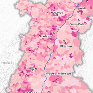
Residential and tertiary sector wood energy consumption in 2016
This map shows the consumption of wood energy in tons/km² per municipality on the Upper Rhine
Simple
- Date (Creation)
- 2022-11-30
- Date (Publication)
- 2023-01-10
- Citation identifier
- 04_2022_293
- Status
- Completed
- Point of contact
-
Organisation name Individual name Electronic mail address Role GeoRhena
GeoRhena
Processor ATMO Grand Est
Custodian
- Maintenance and update frequency
- Not planned
- Keywords
-
-
Map
-
- Keywords
-
-
Upper Rhine
-
-
GEMET - Concepts, version 2.4
-
-
air
-
air quality
-
energy
-
fuel wood
-
- Use limitation
-
Licence CC BY
- Access constraints
- Other restrictions
- Use constraints
- Other restrictions
- Other constraints
-
No other limitation
- Denominator
- 100000
- Language
- Français
- Character set
- UTF8
- Topic category
-
- Environment
- Begin date
- 2016-01-01
- End date
- 2016-12-31
N
S
E
W
))
- Distribution format
-
Name Version PDF Map
-
Digital transfer options
- OnLine resource
-
Protocol Linkage Name WWW:DOWNLOAD-1.0-http--download
https://www.georhena.eu/sites/default/files/Cartes/04_2022_293.pdf Pdf Download
Metadata
- File identifier
- 37a18830-ce10-4213-9b1b-fa91f733623c XML
- Metadata language
- Français
- Character set
- UTF8
- Hierarchy level
- staticMap
- Hierarchy level name
-
Carte statique
- Date stamp
- 2023-03-20T09:53:21.45112Z
- Metadata standard name
-
ISO 19115:2003/19139
- Metadata standard version
-
1.0
- Metadata author
-
Organisation name Individual name Electronic mail address Role GeoRhena: Geographical Information System of the Upper Rhine
Author
- Other language
-
Language Character encoding German UTF8 English UTF8 French UTF8
)))
