 Catalogue DataGrandEst
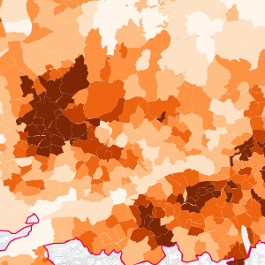
Municipal population in the Upper Rhine (2020)
This data represents the number of inhabitants per municipality in the Upper Rhine area. The German and Swiss data are from 2020 and the French data from 2019.
Simple
- Date (Creation)
- 2022-09-02
- Date (Publication)
- 2023-02-20
- Citation identifier
- population_communale_2020
- Status
- Completed
- Point of contact
-
Organisation name Individual name Electronic mail address Role GeoRhena
GeoRhena
Point of contact Upper Rhine Conference Statistics Working Group
Custodian
- Maintenance and update frequency
- As needed
- Keywords
-
-
Open-Data
-
- Place
-
-
Upper Rhine
-
-
GEMET - INSPIRE themes, version 1.0
-
-
Statistical units
-
Geographical names
-
Administrative units
-
-
GEMET - Concepts, version 2.4
-
-
administrative boundary
-
municipality
-
statistical data
-
demography
-
- Use limitation
-
License CC-BY ©GeoRhena ; ©WG Statistics of the Upper Rhine Conference ; ©INSEE ; ©OFS ; ©STALA BW ; ©STALA R
- Spatial representation type
- Vector
- Denominator
- 50000
- Language
- Français
- Character set
- UTF8
- Topic category
-
- Boundaries
- Begin date
- 2019-01-01
- End date
- 2020-12-31
))
- Distribution format
-
Name Version SHP GeoData
-
Digital transfer options
- OnLine resource
-
Protocol Linkage Name OGC:WMS
https://geoportal.georhena.eu/geoserver/society/ows population_communale_2020
OGC:WFS
https://geoportal.georhena.eu/geoserver/society/ows society:population_communale_2020
WWW:DOWNLOAD-1.0-ftp--download
https://geoportal.georhena.eu/geoserver/society/ows?request=GetFeature&service=WFS&typeName=population_communale_2020&version=1.0.0&outputFormat=SHAPE-ZIP Téléchargement du Shapefile Téléchargement du Shapefile
- Hierarchy level
- Dataset
- Statement
-
Data from the different statistical institutes of the three countries: Statistisches Landesamt Baden-Württemberg (STALA BW) and Statistische Landesamt Rheinland-Pfalz (STALA RP) for Germany, the Federal Statistical Office (FSO) for Switzerland and the Institut national de la statistique et des études économiques (INSEE) for France
Metadata
- File identifier
- 3ea1f7f7-e08b-4f09-bab7-2b86c96b6cf1 XML
- Metadata language
- Français
- Character set
- UTF8
- Hierarchy level
- Dataset
- Date stamp
- 2025-03-14T16:04:11.458057Z
- Metadata standard name
-
ISO 19115:2003/19139
- Metadata standard version
-
1.0
- Metadata author
-
Organisation name Individual name Electronic mail address Role GeoRhena: Geographical Information System of the Upper Rhine
Point of contact
- Other language
-
Language Character encoding German UTF8 English UTF8 French UTF8
)))
