 Catalogue DataGrandEst
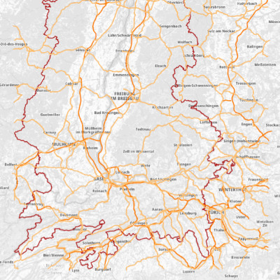
Routes principales du Rhin Supérieur
Hauptstraßen am Oberrhein
Major Roads of the Upper Rhine
Cette donnée décrit le réseau routier principal identifié et extrait depuis Openstreetmap sur l'emprise du territoire du Rhin Supérieur.
Simple
-
Alternate titleAlternate titleAlternate title
-
Réseau routier majeur du Rhin Supérieur
Das Hauptstraßennetz am Oberrhein
Major road network in the Upper Rhine region
- Date (Creation)
- 2026-05-06
- Date (Publication)
- 2026-05-06
- Citation identifier
- reseau_routier
- Status
- Completed
- Point of contact
-
Organisation name Individual name Electronic mail address Role GeoRhena
GeoRhena
Point of contact
- Maintenance and update frequency
- Not planned
- Keywords
-
-
Données ouvertes
Open-Data
Open-Data
-
CRS
ORK
URP
-
- Place
-
-
Rhin Supérieur
Oberrhein
Upper Rhine
-
-
Use limitationUse limitationUse limitation
-
Licence ODbL ©Openstreetmap ©GeoRhena
ODbL Lizenz ©Openstreetmap ©GeoRhena
ODbL Licence ©Openstreetmap ©GeoRhena
- Access constraints
- Other restrictions
- Use constraints
- Other restrictions
-
Other constraintsOther constraintsOther constraints
-
Pas d'autre limitation
Keine andere Einschränkung
No other limitation
- Spatial representation type
- Vector
- Denominator
- 100000
- Language
- Français
- Language
- Deutsch
- Character set
- UTF8
- Character set
- UTF8
- Begin date
- 2026-01-01
- End date
- 2026-12-31
))
- Contains Operations
-
Operation Name Distributed Computing Platforms Connect Point GetCapabilities
Web services https://geoportal.georhena.eu/geoserver/transportation/ows
- Distribution format
-
Name Version Géodonnée au format SHP
GeoDatei im SHP Format
SHP GeoData
-
Digital transfer options
- OnLine resource
-
Protocol Linkage Name OGC:WMS
https://geoportal.georhena.eu/geoserver/transportation/ows reseau_routier
OGC:WFS
https://geoportal.georhena.eu/geoserver/transportation/ows transportation:reseau_routier
- Hierarchy level
- Dataset
- Statement
-
OSM - 2026
Metadata
- File identifier
- 4c3d312d-0952-419f-a1b8-2e339f5fdc42 XML
- Metadata language
- Français
- Character set
- UTF8
- Hierarchy level
- Dataset
- Date stamp
- 2026-06-24T09:27:16.461558Z
- Metadata standard name
-
ISO 19115-3:2018 ISO 19115-3:2018
- Metadata standard version
-
1.0
- Metadata author
-
Organisation name Individual name Electronic mail address Role GeoRhena: Système d'Information Géographique du Rhin Supérieur
Point of contact
)))
