Catalogue DataGrandEst
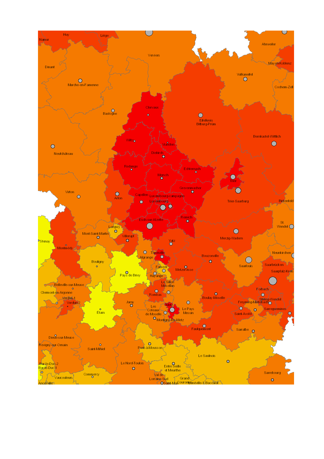
Working age population (20-64 years) in 2016
- Number of persons aged 20-64 years in 2016 (Lorraine: 2014)
- Share of working age population (20 to 64 years) in total population 2016 (in %, Lorraine: 2014)
- Territorial entities: arrondissements (Wallonie), cantons (Lorraine, Luxembourg), Kreise (Saarland, Rheinland-Pfalz)
- Statistical data sources: INSEE Grand Est, Statistisches Landesamt Rheinland-Pfalz, Statistisches Amt Saarland, STATEC, IWEPS. Calculations: LISER 2018
- Geodata sources: ACT Luxembourg 2017, IGN France 2017, GeoBasis-DE / BKG 2017, NGI-Belgium 2017. Harmonization: SIG-GR / GIS-GR 2018
Simple
- Date (Creation)
- 2019-06-21T00:00:00
- Citation identifier
- / 4db3f834-e46c-40d7-ba05-99598d8d5b43
- Presentation form
- Digital map
- Status
- Completed
- Point of contact
-
Organisation name Individual name Electronic mail address Role SIG-GR - Ministère de l'Energie et de l'Aménagement du territoire - Département de l'aménagement du territoire
Thierry Hengen
Author
- Maintenance and update frequency
- Continual
- Keywords
-
-
Population, 20-64 years
-
-
Entités dans la Grande Région
-
-
Greater Region
-
-
gis-gr.eu themes
-
-
Demography
-
-
gis-gr.eu structure
-
-
Demography>Working age population
-
- Keywords
-
-
gis-gr.eu
-
- Access constraints
- Other restrictions
- Spatial representation type
- Vector
- Denominator
- 250000
- Language
- Deutsch
- Language
- Français
- Language
- English
- Character set
- UTF8
- Topic category
-
- Society
))
- Reference system identifier
- EPSG / http://www.opengis.net/def/crs/EPSG/0/3857
- Distribution format
-
Name Version SHAPE
JPEG
PDF
Digital transfer options
- OnLine resource
-
Protocol Linkage Name WWW:LINK-1.0-http--samples
https://map.gis-gr.eu/theme/demographie?version=3&zoom=8&X=667917&Y=6394482&lang=en&layers=1851&opacities=1&bgLayer=basemap_2015_global Interactive map
WWW:LINK-1.0-http--link
https://data.public.lu/en/datasets/working-age-population-20-64-years-in-2016 Open data
OGC:WMS-1.3.0-http-get-map
http://wms.gis-gr.eu/service?service=WMS&version=1.3.0&request=getCapabilities GR/Pop_share_20_64years_2016_sdtgr/Absolute_numbers
OGC:WMS-1.3.0-http-get-map
http://wms.gis-gr.eu/service?service=WMS&version=1.3.0&request=getCapabilities GR/Pop_share_20_64years_2016_sdtgr/Share_percent
Metadata
- File identifier
- 4db3f834-e46c-40d7-ba05-99598d8d5b43 XML
- Metadata language
- Français
- Character set
- UTF8
- Hierarchy level
- Dataset
- Hierarchy level name
-
dataset
- Date stamp
- 2025-01-10T14:22:58
- Metadata standard name
-
ISO 19115:2003/19139
- Metadata standard version
-
1.0
- Metadata author
-
Organisation name Individual name Electronic mail address Role SIG-GR - Ministère de l'Energie et de l'Aménagement du territoire - Département de l'aménagement du territoire
Thierry Hengen
Point of contact
- Other language
-
Language Character encoding English UTF8 German UTF8 French UTF8
)))