 Catalogue DataGrandEst
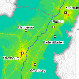
NO2 - Air quality in the Upper Rhine in 2018
This map represents the result of air quality modelling in 2018 on the Upper Rhine. The annual average NO2 amount in µg/m³ is represented according to a categorisation whose values are calibrated around the regulatory limit values of the three countries.
Nitrogen dioxide (NO2) is emitted mainly by vehicles and combustion plants. The regulatory limit values in force are as follows for the annual average: Germany and France: 40 µg/m³, Switzerland: 30 µg/m³. The World Health Organisation's guide value is 40 µg/m³ as an annual average. It should be noted that France is currently involved in a European dispute for non-compliance with the regulatory value, particularly in Strasbourg.
The lowest levels are observed in the Vosges and Black Forest mountain ranges with values below 10 µg/m³ as an annual average. On the other hand, the highest levels are modelled in dense urban areas and along the main road network of the territory, in coherence with the predominantly traffic (43%) and industrial (29%) origin of this pollutant.
On the scale of the Upper Rhine, 47 km² would be exposed to exceeding the 40 µg/m³ threshold out of a total of 21,000 km², i.e. 0.2% of the cross-border territory. The sectors concerned are mainly located on the edges of the main roads of the major conurbations.
Simple
- Date (Creation)
- 2022-11-30
- Date (Publication)
- 2023-03-22
- Citation identifier
- 04_2022_304
- Status
- Completed
- Point of contact
-
Organisation name Individual name Electronic mail address Role GeoRhena
GeoRhena
Processor ATMO Grand Est
Custodian
- Maintenance and update frequency
- Not planned
- Keywords
-
-
Map
-
- Keywords
-
-
Upper Rhine
-
-
GEMET - Concepts, version 2.4
-
-
air quality management
-
air quality control
-
air quality
-
nitrogen dioxide
-
- Use limitation
-
Licence CC BY
- Access constraints
- Other restrictions
- Use constraints
- Other restrictions
- Other constraints
-
No other limitation
- Denominator
- 100000
- Language
- Français
- Character set
- UTF8
- Topic category
-
- Environment
- Begin date
- 2018-01-01
- End date
- 2018-12-31
))
- Distribution format
-
Name Version PDF Map
-
Digital transfer options
- OnLine resource
-
Protocol Linkage Name WWW:DOWNLOAD-1.0-http--download
https://www.georhena.eu/sites/default/files/Cartes/04_2022_304.pdf Pdf Download
WWW:LINK-1.0-http--link
https://www.atmo-grandest.eu/article/atmo-vision-acces-aux-outils-zugang-zu-werkzeugen ATMO Vision website
Metadata
- File identifier
- 53eca2dc-a4d6-46de-86fd-a47dceda75bb XML
- Metadata language
- Français
- Character set
- UTF8
- Hierarchy level
- staticMap
- Hierarchy level name
-
Carte statique
- Date stamp
- 2025-03-31T09:42:38.051455Z
- Metadata standard name
-
ISO 19115:2003/19139
- Metadata standard version
-
1.0
- Metadata author
-
Organisation name Individual name Electronic mail address Role GeoRhena: Geographical Information System of the Upper Rhine
Author
- Other language
-
Language Character encoding German UTF8 English UTF8 French UTF8
)))
