Catalogue DataGrandEst
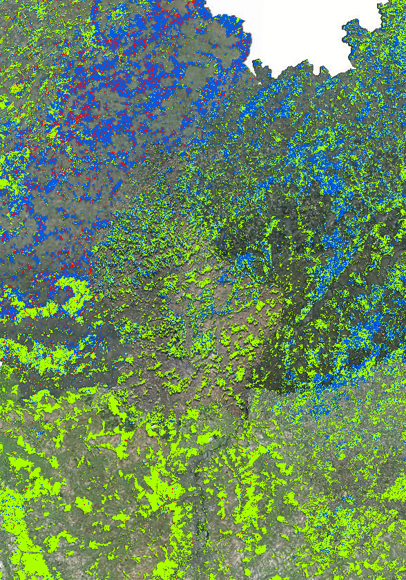
Regiowood: Forest types 2016
Forest types in the Greater Region 2016
- Source: INTERREG VA project Regiowood II ( https://www.regiowood2.info/en)
- Data sources and processing:
- France/Lorraine: SPOT4-5 images acquired in 2005, RapidEye images acquired in 2010 and 2011. Data processing: ICube-SERTIT University of Strasbourg ( https://sertit.unistra.fr)
- Belgium: aerial image coverage from 2009, 2012 and 2016, LiDAR coverage 2014. Data processing: Gembloux Agro-Bio Tech University of Liège ( https://www.gembloux.ulg.ac.be/gestion-des-ressources-forestieres)
- Germany and Luxembourg: cadastral data, Landsat 8 from 2014. Data processing: Umweltfernerkundung & Geoinformatik University of Trier ( https://www.fernerkundung.uni-trier.de/)
- Data for the entire Greater Region from 2016: Sentinel-2 A/B.
Although the classification is based on different methodologies in different regions, the final result is a consistent cross-border map. The accuracy of the classification is 88%.
Please note that the date of the "Aerial Imagery" background map data may differ from the Regiowood data depending on the sub-entity of the Greater Region.
Simple
- Date (Creation)
- 2022-01-06T00:00:00
- Citation identifier
- / 756d6e00-0ec6-47a1-ab15-78b62e3069aa
- Presentation form
- Digital map
- Status
- Completed
- Point of contact
-
Organisation name Individual name Electronic mail address Role SIG-GR - Ministère de l'Energie et de l'Aménagement du territoire - Département de l'aménagement du territoire
Thierry Hengen
Author
- Maintenance and update frequency
- As needed
- Keywords
-
-
Land cover, forest, hardwood, softwood, clear cutting
-
-
Entités dans la Grande Région
-
-
Greater Region
-
-
gis-gr.eu themes
-
-
Land cover
-
-
gis-gr.eu structure
-
-
Land cover>forest
-
- Keywords
-
-
gis-gr.eu
-
- Access constraints
- Other restrictions
- Spatial representation type
- Vector
- Denominator
- 10
- Language
- Deutsch
- Language
- Français
- Language
- English
- Character set
- UTF8
- Topic category
-
- Imagery base maps earth cover
))
- Reference system identifier
- EPSG / http://www.opengis.net/def/crs/EPSG/0/3857
- Distribution format
-
Name Version PDF
JPEG
SHAPE
Digital transfer options
- OnLine resource
-
Protocol Linkage Name WWW:LINK-1.0-http--related
https://www.regiowood2.info/en OGC:WMS
https://ws.geoportail.lu/wss/service/GR_land_cover_WMS/guest Forest_types_Regiowood_2016
WWW:LINK-1.0-http--link
https://data.public.lu/en/datasets/regiowood-forest-types-2016/ Open data
WWW:LINK-1.0-http--samples
https://map.gis-gr.eu/theme/occupation_des_sols?version=3&zoom=8&X=796824&Y=6398814&lang=fr&layers=2088&opacities=1&bgLayer=orthogr_2013_global&crosshair=false Interactive map
OGC:WFS
https://ws.geoportail.lu/wss/service/GR_land_cover_WFS/guest land_cover:Forest_types_Regiowood_2016
Metadata
- File identifier
- 596c32f6-55d5-42ba-adeb-832cb72f05e4 XML
- Metadata language
- Français
- Character set
- UTF8
- Hierarchy level
- Dataset
- Hierarchy level name
-
dataset
- Date stamp
- 2025-04-04T11:39:50
- Metadata standard name
-
ISO 19115:2003/19139
- Metadata standard version
-
1.0
- Metadata author
-
Organisation name Individual name Electronic mail address Role SIG-GR - Ministère de l'Energie et de l'Aménagement du territoire - Département de l'aménagement du territoire
Thierry Hengen
Point of contact
- Other language
-
Language Character encoding English UTF8 German UTF8 French UTF8
)))