 Catalogue DataGrandEst
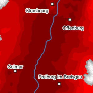
O3 - Air quality in the Upper Rhine in 2018
This map represents the result of air quality modelling in 2018 on the Upper Rhine. The number of days on which the regulatory target value of 120 µg/m³ Ozone is exceeded is shown according to a categorisation based on the limit values of the three countries.
Ozone is produced in the atmosphere by complex chemical reactions between primary pollutants such as nitrogen oxides and volatile organic compounds under the influence of solar radiation.
The regulatory target value is 120 µg/m³ for the daily maximum 8-hour average not to be exceeded on more than 25 days per calendar year averaged over 3 years. The World Health Organisation's guide value is 100 µg/m³ for the daily maximum 8-hour average.
The predominantly red map shows a high number of ozone exceedance days of the 8-hour average of 120 µg/m³ for the entire Upper Rhine in 2018. 99.7% of the area exceeded the 25-day threshold, which is the target value that must not be exceeded over three years. Compared to the mountainous regions, the Rhine valley was slightly more exposed due to the presence of ozone precursor pollutants and potentially higher temperatures.
Simple
- Date (Creation)
- 2022-11-30
- Date (Publication)
- 2023-03-22
- Citation identifier
- 04_2022_307
- Status
- Completed
- Point of contact
-
Organisation name Individual name Electronic mail address Role GeoRhena
GeoRhena
Processor ATMO Grand Est
Custodian
- Maintenance and update frequency
- Not planned
- Keywords
-
-
Map
-
- Keywords
-
-
Upper Rhine
-
-
GEMET - Concepts, version 2.4
-
-
air quality management
-
air quality control
-
air quality
-
ozone
-
- Use limitation
-
Licence CC BY
- Access constraints
- Other restrictions
- Use constraints
- Other restrictions
- Other constraints
-
No other limitation
- Denominator
- 100000
- Language
- Français
- Character set
- UTF8
- Topic category
-
- Environment
- Begin date
- 2018-01-01
- End date
- 2018-12-31
))
- Distribution format
-
Name Version PDF Map
-
Digital transfer options
- OnLine resource
-
Protocol Linkage Name WWW:DOWNLOAD-1.0-http--download
https://www.georhena.eu/sites/default/files/Cartes/04_2022_307.pdf Pdf Download
WWW:LINK-1.0-http--link
https://www.atmo-grandest.eu/article/atmo-vision-acces-aux-outils-zugang-zu-werkzeugen ATMO Vision website
Metadata
- File identifier
- 65ded27b-c1c3-40bd-8cad-9fda790404a3 XML
- Metadata language
- Français
- Character set
- UTF8
- Hierarchy level
- staticMap
- Hierarchy level name
-
Carte statique
- Date stamp
- 2025-03-31T09:43:18.313554Z
- Metadata standard name
-
ISO 19115:2003/19139
- Metadata standard version
-
1.0
- Metadata author
-
Organisation name Individual name Electronic mail address Role GeoRhena: Geographical Information System of the Upper Rhine
Author
- Other language
-
Language Character encoding German UTF8 English UTF8 French UTF8
)))
