Catalogue DataGrandEst
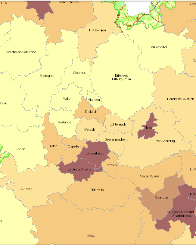
Population density 2019
- Population density 2019 (inhabitants per km²), Lorraine: 2017
- Territorial entities: arrondissements (Wallonie), zones d'emploi (Lorraine), cantons (Luxembourg), Kreise (Saarland, Rheinland-Pfalz)
- Statistical data sources: Destatis, Eurostat, INSEE, Statbel, STATEC. Harmonization: IBA / OIE 2020
- Geodata sources: GeoBasis-DE / BKG 2017, IGN France 2017, NGI-Belgium 2017, ACT Luxembourg 2017. Harmonization: SIG-GR / GIS-GR 2020
Simple
- Date (Creation)
- 2020-12-07T00:00:00
- Citation identifier
- / 676614bf-7cc9-458a-a6a4-2763c3524528
- Presentation form
- Digital map
- Status
- Completed
- Point of contact
-
Organisation name Individual name Electronic mail address Role SIG-GR - Ministère de l'Energie et de l'Aménagement du territoire - Département de l'aménagement du territoire
Thierry Hengen
Author
- Maintenance and update frequency
- Continual
- Keywords
-
-
Population, density
-
-
Entités dans la Grande Région
-
-
Greater Region
-
-
gis-gr.eu themes
-
-
Demography
-
-
gis-gr.eu structure
-
-
Demography>Population density
-
- Keywords
-
-
gis-gr.eu
-
- Access constraints
- Other restrictions
- Spatial representation type
- Vector
- Denominator
- 250000
- Language
- English
- Language
- Deutsch
- Language
- Français
- Character set
- UTF8
))
- Reference system identifier
- EPSG / http://www.opengis.net/def/crs/EPSG/0/3857
- Distribution format
-
Name Version SHAPE
PDF
JPEG
Digital transfer options
- OnLine resource
-
Protocol Linkage Name OGC:WMS-1.3.0-http-get-map
https://ws.geoportail.lu/wss/service/GR_Pop_density_WMS/guest Pop_density_2019
WWW:LINK-1.0-http--link
https://data.public.lu/en/datasets/population-density-2019/ Open data
WWW:LINK-1.0-http--samples
https://map.gis-gr.eu/theme/demographie?version=3&zoom=9&X=740375&Y=6398775&lang=fr&layers=2020&opacities=1&bgLayer=topogg&crosshair= Interactive map
OGC:WFS
https://ws.geoportail.lu/wss/service/GR_Pop_density_WFS/guest Pop_density:Pop_density_2019
Metadata
- File identifier
- 676614bf-7cc9-458a-a6a4-2763c3524528 XML
- Metadata language
- Français
- Character set
- UTF8
- Hierarchy level
- Dataset
- Hierarchy level name
-
dataset
- Date stamp
- 2025-01-10T13:32:38
- Metadata standard name
-
ISO 19115:2003/19139
- Metadata standard version
-
1.0
- Metadata author
-
Organisation name Individual name Electronic mail address Role SIG-GR - Ministère de l'Energie et de l'Aménagement du territoire - Département de l'aménagement du territoire
Thierry Hengen
Point of contact
- Other language
-
Language Character encoding English UTF8 German UTF8 French UTF8
)))