 Catalogue DataGrandEst
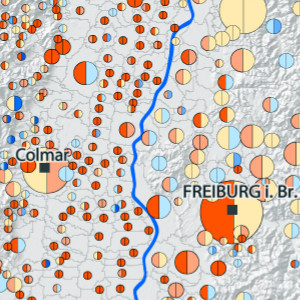
Comparaison de l’évolution de la population communale du Rhin Supérieur (1999 - 2006 et 2006 - 2009)
Vergleich der kommunalen Bevölkerungsentwicklung am Oberrhein (1999 - 2006 und 2006 - 2009)
Comparison of municipal population development in the Upper Rhine (1999 - 2006 and 2006 - 2009)
Cette carte met en parallèle les évolutions de la population communale sur les périodes 1999-2006 et 2006-2009 sur le territoire du Rhin supérieur.
Diese Karte stellt die Entwicklung der Gemeindebevölkerung in den Zeiträumen 1999-2006 und 2006-2009 auf dem Gebiet des Oberrheins gegenüber.
This map compares the changes in the municipal population over the periods 1999-2006 and 2006-2009 in the Upper Rhine area.
Simple
-
Datumsangaben (Erstellung)Date (Creation)Date (Création)
- 2012-10-01
-
Datumsangaben (Publikation)Date (Publication)Date (Publication)
- 2012-10-01
-
IdentifikatorCitation identifierIdentificateur
- 05_2013_0179
-
BearbeitungsstatusStatusEtat
-
AbgeschlossenCompletedFinalisé
- Point of contact
-
Organisation name Individual name Electronic mail address Role GeoRhena
GeoRhena
GeoRhena
GeoRhena
BearbeiterProcessorExécutant
-
ÜberarbeitungsintervallMaintenance and update frequencyFréquence de mise à jour
-
Nicht geplantNot plannedNon planifiée
- Keywords
-
-
Carte
Karte
Map
-
- Keywords
-
-
Rhin Supérieur
Oberrhein
Upper Rhine
-
-
GEMET - Concepts, version 2.4
-
-
démographie
Demographie
demography
-
habitant
Bewohner
inhabitant
-
-
Limitation d'utilisationAnwendungseinschränkungenUse limitation
-
Licence CC BY
Licence CC BY
Licence CC BY
-
ZugriffseinschränkungenAccess constraintsContraintes d'accès
-
Benutzerdefinierte EinschränkungenOther restrictionsAutres restrictions
-
NutzungseinschränkungenUse constraintsContraintes d'utilisation
-
Benutzerdefinierte EinschränkungenOther restrictionsAutres restrictions
-
Autres contraintesAndere EinschränkungenOther constraints
-
Pas d'autre limitation
Keine andere Einschränkung
No other limitation
-
MaßstabszahlDenominatorDénominateur de l'échelle
- 100000
-
SpracheLanguageLangue de la ressource
- Français
-
ZeichensatzCharacter setEncodage des caractères
-
Utf8UTF8Utf8
-
ISO-ThematikTopic categoryCatégorie ISO
-
-
GesellschaftSocietySociété
-
- Begin date
- 1999-01-29
- End date
- 2009-12-31
))
- Distribution format
-
Name Version Carte au format PDF
Karte in PDF
PDF Map
-
Digitale Transferoptionen
Digital transfer options
Options de transfert numérique
- OnLine resource
-
Protocol Linkage Name WWW:DOWNLOAD-1.0-http--download
https://www.georhena.eu/sites/default/files/Cartes/05_2013_0179.pdf Téléchargement du Pdf
Pdf herunterladen
Pdf Download
Metadata
-
MetadatensatzidentifikatorFile identifierIdentifiant de la fiche
- 6a320107-55e3-4a36-8027-e97dd03f0152 XML
-
SpracheMetadata languageLangue
- Français
-
ZeichensatzCharacter setJeu de caractères
-
Utf8UTF8Utf8
-
HierarchieebeneHierarchy levelType de ressource
-
staticMapstaticMapstaticMap
- Hierarchy level name
-
Carte statique
-
DatumDate stampDate des métadonnées
- 2022-10-19T07:47:05.426105Z
- Metadata standard name
-
ISO 19115:2003/19139
- Metadata standard version
-
1.0
- Metadata author
-
Organisation name Individual name Electronic mail address Role GeoRhena: Système d'Information Géographique du Rhin Supérieur
GeoRhena: Geographische Informationssystem des Oberrheins
GeoRhena: Geographical Information System of the Upper Rhine
AutorAuthorAuteur
- Other language
-
Language Character encoding DeutschGermanAllemandUtf8UTF8Utf8EnglischEnglishAnglaisUtf8UTF8Utf8FranzösischFrenchFrançaisUtf8UTF8Utf8
Overviews
Spatial extent
)))
Provided by
