 Catalogue DataGrandEst
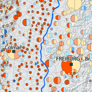
Comparison of municipal population development in the Upper Rhine (1999 - 2006 and 2006 - 2009)
This map compares the changes in the municipal population over the periods 1999-2006 and 2006-2009 in the Upper Rhine area.
Simple
- Date (Creation)
- 2012-10-01
- Date (Publication)
- 2012-10-01
- Citation identifier
- 05_2013_0179
- Status
- Completed
- Point of contact
-
Organisation name Individual name Electronic mail address Role GeoRhena
GeoRhena
Processor
- Maintenance and update frequency
- Not planned
- Keywords
-
-
Map
-
- Keywords
-
-
Upper Rhine
-
-
GEMET - Concepts, version 2.4
-
-
demography
-
inhabitant
-
- Use limitation
-
Licence CC BY
- Access constraints
- Other restrictions
- Use constraints
- Other restrictions
- Other constraints
-
No other limitation
- Denominator
- 100000
- Language
- Français
- Character set
- UTF8
- Topic category
-
- Society
- Begin date
- 1999-01-29
- End date
- 2009-12-31
N
S
E
W
))
- Distribution format
-
Name Version PDF Map
-
Digital transfer options
- OnLine resource
-
Protocol Linkage Name WWW:DOWNLOAD-1.0-http--download
https://www.georhena.eu/sites/default/files/Cartes/05_2013_0179.pdf Pdf Download
Metadata
- File identifier
- 6a320107-55e3-4a36-8027-e97dd03f0152 XML
- Metadata language
- Français
- Character set
- UTF8
- Hierarchy level
- staticMap
- Hierarchy level name
-
Carte statique
- Date stamp
- 2022-10-19T07:47:05.426105Z
- Metadata standard name
-
ISO 19115:2003/19139
- Metadata standard version
-
1.0
- Metadata author
-
Organisation name Individual name Electronic mail address Role GeoRhena: Geographical Information System of the Upper Rhine
Author
- Other language
-
Language Character encoding German UTF8 English UTF8 French UTF8
)))
