Catalogue DataGrandEst
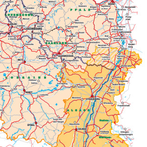
General map of international cooperation areas in the Greater Region and the Upper Rhine
Map of cross-border cooperation areas in the Greater Region and the Upper Rhine.
Simple
- Date (Creation)
- 2015-08-01
- Date (Publication)
- 2015-08-01
- Citation identifier
- 04_2015_0233
- Status
- On going
- Point of contact
-
Organisation name Individual name Electronic mail address Role GeoRhena
GeoRhena
Point of contact
- Maintenance and update frequency
- As needed
- Place
-
-
Rhin Supérieur / Oberrhein
-
-
GEMET - Concepts, version 2.4
-
-
international co-operation
-
- Access constraints
- Other restrictions
- Use constraints
- Other restrictions
- Other constraints
-
Ajoutez logo GeoRhena en cas de réutilisation / Das GeoRhena Logo verwenden für alle benutzung dieser Daten
- Spatial representation type
- Vector
- Denominator
- 100000
- Language
- Français
- Character set
- UTF8
- Topic category
-
- Boundaries
- Begin date
- 2015-01-01
- End date
- 2015-12-31
N
S
E
W
))
- Reference system identifier
- EPSG / 4258 / ETRS89 / 7.4
- Distribution format
-
Name Version SHP GeoData
-
Digital transfer options
- OnLine resource
-
Protocol Linkage Name WWW:DOWNLOAD-1.0-http--download
https://www.georhena.eu/sites/default/files/Cartes/04_2015_0233.pdf
- Hierarchy level
- staticMap
- Statement
-
GeoRhena + OSM contributors
Metadata
- File identifier
- 6a70077b-e48a-42da-b2ab-76ca12005162 XML
- Metadata language
- Français
- Character set
- UTF8
- Hierarchy level
- staticMap
- Date stamp
- 2022-10-25T07:46:59.620606Z
- Metadata standard name
-
ISO 19115:2003/19139
- Metadata standard version
-
1.0
- Metadata author
-
Organisation name Individual name Electronic mail address Role GeoRhena
GeoRhena
Point of contact
- Other language
-
Language Character encoding German UTF8 English UTF8 French UTF8
)))