Catalogue DataGrandEst
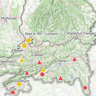
Concentrations d’ammoniac mesurées dans le Rhin supérieur (2021-2022)
Gemessene Ammoniak-Konzentrationen am Oberrhein (2021-2022)
Ammonia concentrations measured in the Upper Rhine (2021-2022)
Produite dans le cadre du projet Interreg Rhin Supérieur Atmo-Rhena PLUS , cette carte représente les mesures de l’ammoniac sur le territoire du Rhin supérieur.
L'ammoniac (NH3) est un composé gazeux dans l'atmosphère. A très fortes concentrations, ce gaz devient irritant pour les voies respiratoires et les yeux. Aux concentrations habituellement rencontrées en air ambiant ses effets sanitaires directs sont faibles, à la différence des effets environnementaux engendrés (l’ammoniac joue un rôle majeur dans l'acidification et l'eutrophisation des milieux naturels). De plus, l’ammoniac réagit avec d’autres substances présentes dans l’atmosphère pour former des particules fines secondaires.
L'ammoniac est majoritairement émis par l'agriculture, principalement par les épandages d’engrais et les déjections animales de l'élevage. En zone urbaine, le secteur résidentiel, la gestion des déchets, certaines industries ou encore le transport routier sont également responsables d’émissions d’ammoniac.
Les niveaux annuels sur le Rhin supérieur sont compris entre 0.5 et 8.2 µg/m3. Les sites associés aux plus grandes concentrations sont ceux à proximité d'une source agricole ou du trafic routier. Parmi les 21 sites, 19 sites sont supérieurs à la limite annuelle pour la protection de la végétation sensible et 8 sites sont supérieurs à la limite pour la protection de la végétation totale.
Diese Karte wurde im Rahmen des Interreg-Projekts Oberrhein Atmo-Rhena PLUS erstellt und stellt die Ammoniakmessungen im Oberrheingebiet dar.
Ammoniak (NH3) ist eine gasförmige Verbindung in der Atmosphäre, die bei sehr hohen Konzentrationen die Atemwege und die Augen reizen kann. Bei den üblichen Konzentrationen in der Umgebungsluft sind die direkten gesundheitlichen Auswirkungen gering, jedoch trägt Ammoniak auch in geringen Konzentration zur Eutrophierung und Versauerung natürlicher Ökosysteme bei. Des Weiteren reagiert Ammoniak mit anderen Substanzen in der Atmosphäre und bildet sekundäre Feinstaubpartikel.
Ammoniak wird hauptsächlich von der Landwirtschaft freigesetzt, insbesondere durch Düngemittel und tierische Ausscheidungen aus der Viehzucht. Weitere Ammoniakquellen finden sich im städtischen Bereich, wie dem Straßenverkehr, der Holzverbrennung, der Abfallwirtschaft und verschiedenen Industriezweige.
Die Jahresmittelwerte für NH3 am Oberrhein liegen zwischen 0,5 und 8,2 µg/m3. Die Standorte mit den höchsten Konzentrationen befinden sich in der Nähe landwirtschaftlicher Aktivitäten oder des Straßenverkehrs, was den Einfluss dieser Quellen verdeutlicht. Von den 21 Standorten lagen 19 Standorte über dem Jahresgrenzwert für den Schutz empfindlicher Vegetation und 8 Standorte über dem Grenzwert für den Schutz der gesamten Vegetation.
Produced as part of the Interreg Upper Rhine Atmo-Rhena PLUS project, this map shows ammonia measurements in the Upper Rhine region.
Ammonia (NH3) is a gaseous compound in the atmosphere. At very high concentrations, this gas is irritating to the respiratory tract and eyes. At the concentrations usually found in ambient air, its direct health effects are low, unlike the environmental effects it causes (ammonia plays a major role in the acidification and eutrophication of natural environments). In addition, ammonia reacts with other substances in the atmosphere to form secondary fine particles.
Ammonia is mainly emitted by agriculture, mainly through the spreading of fertilisers and animal waste from livestock farming. In urban areas, the residential sector, waste management, certain industries and road transport are also responsible for ammonia emissions.
Annual levels on the Upper Rhine range from 0.5 to 8.2 µg/m3. The sites associated with the highest concentrations are those close to an agricultural source or road traffic. Of the 21 sites, 19 exceeded the annual limit for the protection of sensitive vegetation and 8 exceeded the limit for the protection of total vegetation.
Simple
-
Datumsangaben (Erstellung)Date (Creation)Date (Création)
- 2024-02-14
-
Datumsangaben (Publikation)Date (Publication)Date (Publication)
- 2024-04-18
-
IdentifikatorCitation identifierIdentificateur
- 07_2024_327
-
BearbeitungsstatusStatusEtat
-
AbgeschlossenCompletedFinalisé
- Point of contact
-
Organisation name Individual name Electronic mail address Role GeoRhena
GeoRhena
GeoRhena
GeoRhena
BearbeiterProcessorExécutantATMO Grand Est
ATMO Grand Est
ATMO Grand Est
VerwalterCustodianGestionnaireLandesanstalt für Umwelt Baden-Württemberg (LUBW)
VerwalterCustodianGestionnaireLufthygieneamt beider Basel
VerwalterCustodianGestionnaire
-
ÜberarbeitungsintervallMaintenance and update frequencyFréquence de mise à jour
-
Nicht geplantNot plannedNon planifiée
- Keywords
-
-
Carte
Karte
Map
-
- Keywords
-
-
Rhin Supérieur
Oberrhein
Upper Rhine
-
-
GEMET - Concepts, version 2.4
-
-
contrôle de la qualité de l'air
Luftgüteüberwachung
air quality control
-
qualité de l'air
Luftgüte
air quality
-
pollution atmosphérique
Atmosphärische Verunreinigung
atmospheric pollution
-
acidification
Versauerung
acidification
-
ammoniac
Ammoniak
ammonia
-
eutrophisation
Eutrophierung
eutrophication
-
particule
Partikel
particle
-
agriculture
Landwirtschaft
agriculture
-
engrais
Düngemittel
fertiliser
-
trafic routier
Straßenverkehr
road traffic
-
mesure de pollution
Schadstoffmessung
pollution measurement
-
végétation
Vegetation
vegetation
-
élevage
Tierhaltung
animal husbandry
-
-
Limitation d'utilisationAnwendungseinschränkungenUse limitation
-
Licence CC BY
Licence CC BY
Licence CC BY
-
ZugriffseinschränkungenAccess constraintsContraintes d'accès
-
Benutzerdefinierte EinschränkungenOther restrictionsAutres restrictions
-
NutzungseinschränkungenUse constraintsContraintes d'utilisation
-
Benutzerdefinierte EinschränkungenOther restrictionsAutres restrictions
-
Autres contraintesAndere EinschränkungenOther constraints
-
Pas d'autre limitation
Keine andere Einschränkung
No other limitation
-
MaßstabszahlDenominatorDénominateur de l'échelle
- 700000
-
SpracheLanguageLangue de la ressource
- Français
-
SpracheLanguageLangue de la ressource
- Deutsch
-
SpracheLanguageLangue de la ressource
- English
-
ZeichensatzCharacter setEncodage des caractères
-
Utf8UTF8Utf8
-
ISO-ThematikTopic categoryCatégorie ISO
-
-
UmweltEnvironmentEnvironnement
-
- Begin date
- 2021-01-01
- End date
- 2022-12-31
- Distribution format
-
Name Version Carte au format PDF
Karte in PDF
PDF Map
-
Digitale Transferoptionen
Digital transfer options
Options de transfert numérique
- OnLine resource
-
Protocol Linkage Name WWW:DOWNLOAD-1.0-http--download https://www.georhena.eu/sites/default/files/Cartes/07_2024_327.pdf Téléchargement du Pdf
Pdf herunterladen
Pdf Download
WWW:LINK-1.0-http--link
https://www.atmo-grandest.eu/projets-transfrontaliers/atmo-rhena-plus/fr Site internet du projet
Webseite des Projekts
Project website
-
Généralités sur la provenanceErläuterung
-
Mesures des réseaux de surveillance de la qualité de l’air de la région Grand est (ATMO Grand Est), du Bade Wurtemberg (Landesanstalt für Umwelt Bade-Wurtemberg – LUBW) et des Cantons de Bâle Ville et Bâle Campagne (Lufthygienamt Beider Basel – LHA).
Messungen der Netzwerke zur Überwachung der Luftqualität in der Region Grand Est (ATMO Grand Est), in Baden-Württemberg (Landesanstalt für Umwelt Baden-Württemberg - LUBW) und in den Kantonen Basel-Stadt und Basel-Landschaft (Lufthygienamt Beider Basel - LHA).
Metadata
-
MetadatensatzidentifikatorFile identifierIdentifiant de la fiche
- 779807f1-dbab-4a40-a467-ef03f18c6441 XML
-
SpracheMetadata languageLangue
- Français
-
ZeichensatzCharacter setJeu de caractères
-
Utf8UTF8Utf8
-
HierarchieebeneHierarchy levelType de ressource
-
staticMapstaticMapstaticMap
- Hierarchy level name
-
Carte statique
-
DatumDate stampDate des métadonnées
- 2025-06-18T12:42:21.396035Z
- Metadata standard name
-
ISO 19115:2003/19139
- Metadata standard version
-
1.0
- Metadata author
-
Organisation name Individual name Electronic mail address Role GeoRhena: Système d'Information Géographique du Rhin Supérieur
GeoRhena: Geographische Informationssystem des Oberrheins
GeoRhena: Geographical Information System of the Upper Rhine
AutorAuthorAuteur
- Other language
-
Language Character encoding DeutschGermanAllemandUtf8UTF8Utf8EnglischEnglishAnglaisUtf8UTF8Utf8FranzösischFrenchFrançaisUtf8UTF8Utf8