Catalogue DataGrandEst
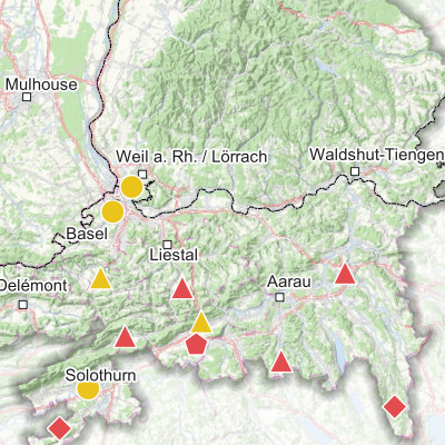
Ammonia concentrations measured in the Upper Rhine (2021-2022)
Produced as part of the Interreg Upper Rhine Atmo-Rhena PLUS project, this map shows ammonia measurements in the Upper Rhine region.
Ammonia (NH3) is a gaseous compound in the atmosphere. At very high concentrations, this gas is irritating to the respiratory tract and eyes. At the concentrations usually found in ambient air, its direct health effects are low, unlike the environmental effects it causes (ammonia plays a major role in the acidification and eutrophication of natural environments). In addition, ammonia reacts with other substances in the atmosphere to form secondary fine particles.
Ammonia is mainly emitted by agriculture, mainly through the spreading of fertilisers and animal waste from livestock farming. In urban areas, the residential sector, waste management, certain industries and road transport are also responsible for ammonia emissions.
Annual levels on the Upper Rhine range from 0.5 to 8.2 µg/m3. The sites associated with the highest concentrations are those close to an agricultural source or road traffic. Of the 21 sites, 19 exceeded the annual limit for the protection of sensitive vegetation and 8 exceeded the limit for the protection of total vegetation.
Simple
- Date (Creation)
- 2024-02-14
- Date (Publication)
- 2024-04-18
- Citation identifier
- 07_2024_327
- Status
- Completed
- Point of contact
-
Organisation name Individual name Electronic mail address Role GeoRhena
GeoRhena
Processor ATMO Grand Est
Custodian Landesanstalt für Umwelt Baden-Württemberg (LUBW)
Custodian Lufthygieneamt beider Basel
Custodian
- Maintenance and update frequency
- Not planned
- Keywords
-
-
Map
-
- Keywords
-
-
Upper Rhine
-
-
GEMET - Concepts, version 2.4
-
-
air quality control
-
air quality
-
atmospheric pollution
-
acidification
-
ammonia
-
eutrophication
-
particle
-
agriculture
-
fertiliser
-
road traffic
-
pollution measurement
-
vegetation
-
animal husbandry
-
- Use limitation
-
Licence CC BY
- Access constraints
- Other restrictions
- Use constraints
- Other restrictions
- Other constraints
-
No other limitation
- Denominator
- 700000
- Language
- Français
- Language
- Deutsch
- Language
- English
- Character set
- UTF8
- Topic category
-
- Environment
- Begin date
- 2021-01-01
- End date
- 2022-12-31
- Distribution format
-
Name Version PDF Map
-
Digital transfer options
- OnLine resource
-
Protocol Linkage Name WWW:DOWNLOAD-1.0-http--download https://www.georhena.eu/sites/default/files/Cartes/07_2024_327.pdf Pdf Download
WWW:LINK-1.0-http--link
https://www.atmo-grandest.eu/projets-transfrontaliers/atmo-rhena-plus/fr Project website
- Statement
-
Mesures des réseaux de surveillance de la qualité de l’air de la région Grand est (ATMO Grand Est), du Bade Wurtemberg (Landesanstalt für Umwelt Bade-Wurtemberg – LUBW) et des Cantons de Bâle Ville et Bâle Campagne (Lufthygienamt Beider Basel – LHA).
Metadata
- File identifier
- 779807f1-dbab-4a40-a467-ef03f18c6441 XML
- Metadata language
- Français
- Character set
- UTF8
- Hierarchy level
- staticMap
- Hierarchy level name
-
Carte statique
- Date stamp
- 2025-06-18T12:42:21.396035Z
- Metadata standard name
-
ISO 19115:2003/19139
- Metadata standard version
-
1.0
- Metadata author
-
Organisation name Individual name Electronic mail address Role GeoRhena: Geographical Information System of the Upper Rhine
Author
- Other language
-
Language Character encoding German UTF8 English UTF8 French UTF8