 Catalogue DataGrandEst
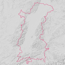
Périmètre de la Conférence du Rhin Supérieur
Oberrheinkonferenz Perimeter
Upper Rhine Perimeter
Périmètre de la Conférence du Rhin Supérieur et de la Région Métropolitaine Trinationale du Rhin Supérieur
Oberrheinkonferenz und Trinationalen Metropolregion Oberrhein Perimeter
Upper Rhine Perimeter
Simple
-
Autres appellations ou acronymesAlternativtitelAlternate title
-
Périmètre Rhin Supérieur
Oberrhein Perimeter
Upper Rhine Perimeter
-
Datumsangaben (Erstellung)Date (Creation)Date (Création)
- 2016-01-01
-
Datumsangaben (Publikation)Date (Publication)Date (Publication)
- 2016-01-01
-
IdentifikatorCitation identifierIdentificateur
- ContourCRS_UmrissORK
-
BearbeitungsstatusStatusEtat
-
AbgeschlossenCompletedFinalisé
- Point of contact
-
Organisation name Individual name Electronic mail address Role GeoRhena
GeoRhena
GeoRhena
GeoRhena
AnsprechpartnerPoint of contactPoint de contact
-
ÜberarbeitungsintervallMaintenance and update frequencyFréquence de mise à jour
-
JährlichAnnuallyAnnuelle
- Keywords
-
-
Données ouvertes
Open-Data
Open-Data
-
CRS
ORK
URP
-
-
OrtPlaceLocalisation
-
-
Rhin Supérieur
Oberrhein
Upper Rhine
-
-
GEMET - INSPIRE themes, version 1.0
-
-
Unités administratives
Verwaltungseinheiten
Administrative units
-
Dénominations géographiques
Geografische Bezeichnungen
Geographical names
-
Unités statistiques
Statistische Einheiten
Statistical units
-
-
GEMET - Concepts, version 2.4
-
-
limite administrative
Verwaltungsgrenze
administrative boundary
-
communauté urbaine
Städtisches Gemeinwesen
urban community
-
commune
Gemeinde
municipality
-
-
Limitation d'utilisationAnwendungseinschränkungenUse limitation
-
© + OSM contributors + Ajoutez logo GeoRhena en cas de réutilisation
© + OSM contributors + Das GeoRhena Logo verwenden für alle benutzung dieser Daten
© + OSM contributors + Add GeoRhena logo in case of reuse
-
ZugriffseinschränkungenAccess constraintsContraintes d'accès
-
Benutzerdefinierte EinschränkungenOther restrictionsAutres restrictions
-
NutzungseinschränkungenUse constraintsContraintes d'utilisation
-
Benutzerdefinierte EinschränkungenOther restrictionsAutres restrictions
-
Autres contraintesAndere EinschränkungenOther constraints
-
Pas d'autre limitation
Keine andere Einschränkung
No other limitation
-
Räumliche DarstellungsartSpatial representation typeType de représentation spatiale
-
VektorVectorVecteur
-
MaßstabszahlDenominatorDénominateur de l'échelle
- 100000
-
SpracheLanguageLangue de la ressource
- English
-
ZeichensatzCharacter setEncodage des caractères
-
Utf8UTF8Utf8
-
ISO-ThematikTopic categoryCatégorie ISO
-
-
GrenzenBoundariesLimites politiques et administratives
-
- Begin date
- 2016-01-01
- End date
- 2030-01-01
))
- Distribution format
-
Name Version Géodonnée au format SHP
GeoDatei im SHP Format
SHP GeoData
-
Digitale Transferoptionen
Digital transfer options
Options de transfert numérique
- OnLine resource
-
Protocol Linkage Name OGC:WMS
https://geoportal.georhena.eu/geoserver/boundaries/ows limite_crs
limite_crs
limite_crs
OGC:WFS
https://geoportal.georhena.eu/geoserver/boundaries/ows limite_crs
WWW:DOWNLOAD-1.0-ftp--download
https://geoportal.georhena.eu/geoserver/boundaries/ows?request=GetFeature&service=WFS&typeName=limite_crs&version=1.0.0&outputFormat=SHAPE-ZIP Téléchargement du Shapefile
Téléchargement du Shapefile
Téléchargement du Shapefile
-
BezugsebeneHierarchy levelNiveau
-
DatenbestandDatasetJeu de données
-
Généralités sur la provenanceErläuterungStatement
-
GeoRhena + OSM contributors - 2020
GeoRhena + OSM contributors - 2020
GeoRhena + OSM contributors - 2020
Metadata
-
MetadatensatzidentifikatorFile identifierIdentifiant de la fiche
- 7b11840e-f144-4c80-bc76-19155199316c XML
-
SpracheMetadata languageLangue
- Français
-
ZeichensatzCharacter setJeu de caractères
-
Utf8UTF8Utf8
-
HierarchieebeneHierarchy levelType de ressource
-
DatenbestandDatasetJeu de données
-
DatumDate stampDate des métadonnées
- 2025-06-13T11:39:38.415863Z
- Metadata standard name
-
ISO 19115:2003/19139
- Metadata standard version
-
1.0
- Metadata author
-
Organisation name Individual name Electronic mail address Role GeoRhena: Système d'Information Géographique du Rhin Supérieur
GeoRhena: Geographische Informationssystem des Oberrheins
GeoRhena: Geographical Information System of the Upper Rhine
AnsprechpartnerPoint of contactPoint de contact
- Other language
-
Language Character encoding DeutschGermanAllemandUtf8UTF8Utf8EnglischEnglishAnglaisUtf8UTF8Utf8FranzösischFrenchFrançaisUtf8UTF8Utf8
)))
