 Catalogue DataGrandEst
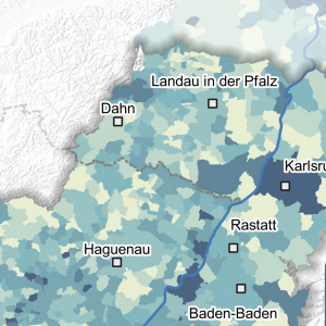
Pouvoir de réchauffement global par habitant en 2016
Global Erwärmungspotenz pro Einwohner im 2016
Global warming power per inhabitant in 2016
Cette carte représente le Pouvoir de Réchauffement Global (PRG) en kg/habitant par commune sur le Rhin supérieur. Le Pouvoir de Réchauffement Global a été défini afin de déterminer l’impact global issu de la contribution de chacun des GES sur les changements climatiques à partir de leurs PRG respectifs. Il s’exprime en équivalent CO2 (CO2e). Ici le PRG est calculé avec les coefficients indiqués dans la méthode du 5ème rapport du GIEC (2013) à savoir un pouvoir de réchauffement 28 fois supérieur à celui du CO2 pour le méthane et 265 fois pour le protoxyde d’azote.
Diese Karte stellt die Globale Erwärmungspotenz (GWP) in kg/Einwohner pro Gemeinde am Oberrhein dar.. Die globale Erwärmungskraft wurde definiert, um die Gesamtwirkung zu bestimmen, die sich aus dem Beitrag der einzelnen Treibhausgase zum Klimawandel aus ihrem jeweiligen GWP ergibt. Sie wird in CO2-Äquivalent (CO2e) ausgedrückt. Hier wird das GWP mit den Koeffizienten berechnet, die im 5. Bericht des IPPC von 2013 angegeben sind, d.h. eine 28 Mal höhere Erwärmungsleistung für Methan als die von CO2 und eine 265 Mal höhere für Distickstoffmonoxid als die von CO2.
This map shows the Global Warming Power (GWP) in kg/capita per municipality in the Upper Rhine. The Global Warming Power was defined in order to determine the global impact of the contribution of each GHG to climate change from their respective GWP. It is expressed in CO2 equivalent (CO2e). Here the GWP is calculated with the coefficients indicated in the method of the 5th IPCC report (2013), i.e. a warming power 28 times greater than that of CO2 for methane and 265 times for nitrous oxide.
Simple
-
Datumsangaben (Erstellung)Date (Creation)Date (Création)
- 2022-11-30
-
Datumsangaben (Publikation)Date (Publication)Date (Publication)
- 2023-03-20
-
IdentifikatorCitation identifierIdentificateur
- 04_2022_294
-
BearbeitungsstatusStatusEtat
-
AbgeschlossenCompletedFinalisé
- Point of contact
-
Organisation name Individual name Electronic mail address Role GeoRhena
GeoRhena
GeoRhena
GeoRhena
BearbeiterProcessorExécutantATMO Grand Est
ATMO Grand Est
ATMO Grand Est
VerwalterCustodianGestionnaire
-
ÜberarbeitungsintervallMaintenance and update frequencyFréquence de mise à jour
-
Nicht geplantNot plannedNon planifiée
- Keywords
-
-
Carte
Karte
Map
-
- Keywords
-
-
Rhin Supérieur
Oberrhein
Upper Rhine
-
-
GEMET - Concepts, version 2.4
-
-
air
Luft
air
-
qualité de l'air
Luftgüte
air quality
-
réchauffement mondial
Treibhauseffekt-Potential
global warming
-
-
Limitation d'utilisationAnwendungseinschränkungenUse limitation
-
Licence CC BY
Licence CC BY
Licence CC BY
-
ZugriffseinschränkungenAccess constraintsContraintes d'accès
-
Benutzerdefinierte EinschränkungenOther restrictionsAutres restrictions
-
NutzungseinschränkungenUse constraintsContraintes d'utilisation
-
Benutzerdefinierte EinschränkungenOther restrictionsAutres restrictions
-
Autres contraintesAndere EinschränkungenOther constraints
-
Pas d'autre limitation
Keine andere Einschränkung
No other limitation
-
MaßstabszahlDenominatorDénominateur de l'échelle
- 100000
-
SpracheLanguageLangue de la ressource
- Français
-
ZeichensatzCharacter setEncodage des caractères
-
Utf8UTF8Utf8
-
ISO-ThematikTopic categoryCatégorie ISO
-
-
UmweltEnvironmentEnvironnement
-
- Begin date
- 2016-01-01
- End date
- 2016-12-31
))
- Distribution format
-
Name Version Carte au format PDF
Karte in PDF
PDF Map
-
Digitale Transferoptionen
Digital transfer options
Options de transfert numérique
- OnLine resource
-
Protocol Linkage Name WWW:DOWNLOAD-1.0-http--download
https://www.georhena.eu/sites/default/files/Cartes/04_2022_294.pdf Téléchargement du Pdf
Pdf herunterladen
Pdf Download
Metadata
-
MetadatensatzidentifikatorFile identifierIdentifiant de la fiche
- 8db299fd-c414-418c-a4ba-0c5ac25fcd02 XML
-
SpracheMetadata languageLangue
- Français
-
ZeichensatzCharacter setJeu de caractères
-
Utf8UTF8Utf8
-
HierarchieebeneHierarchy levelType de ressource
-
staticMapstaticMapstaticMap
- Hierarchy level name
-
Carte statique
-
DatumDate stampDate des métadonnées
- 2023-03-20T13:30:25.961855Z
- Metadata standard name
-
ISO 19115:2003/19139
- Metadata standard version
-
1.0
- Metadata author
-
Organisation name Individual name Electronic mail address Role GeoRhena: Système d'Information Géographique du Rhin Supérieur
GeoRhena: Geographische Informationssystem des Oberrheins
GeoRhena: Geographical Information System of the Upper Rhine
AutorAuthorAuteur
- Other language
-
Language Character encoding DeutschGermanAllemandUtf8UTF8Utf8EnglischEnglishAnglaisUtf8UTF8Utf8FranzösischFrenchFrançaisUtf8UTF8Utf8
Overviews
Spatial extent
)))
Provided by
