Catalogue DataGrandEst
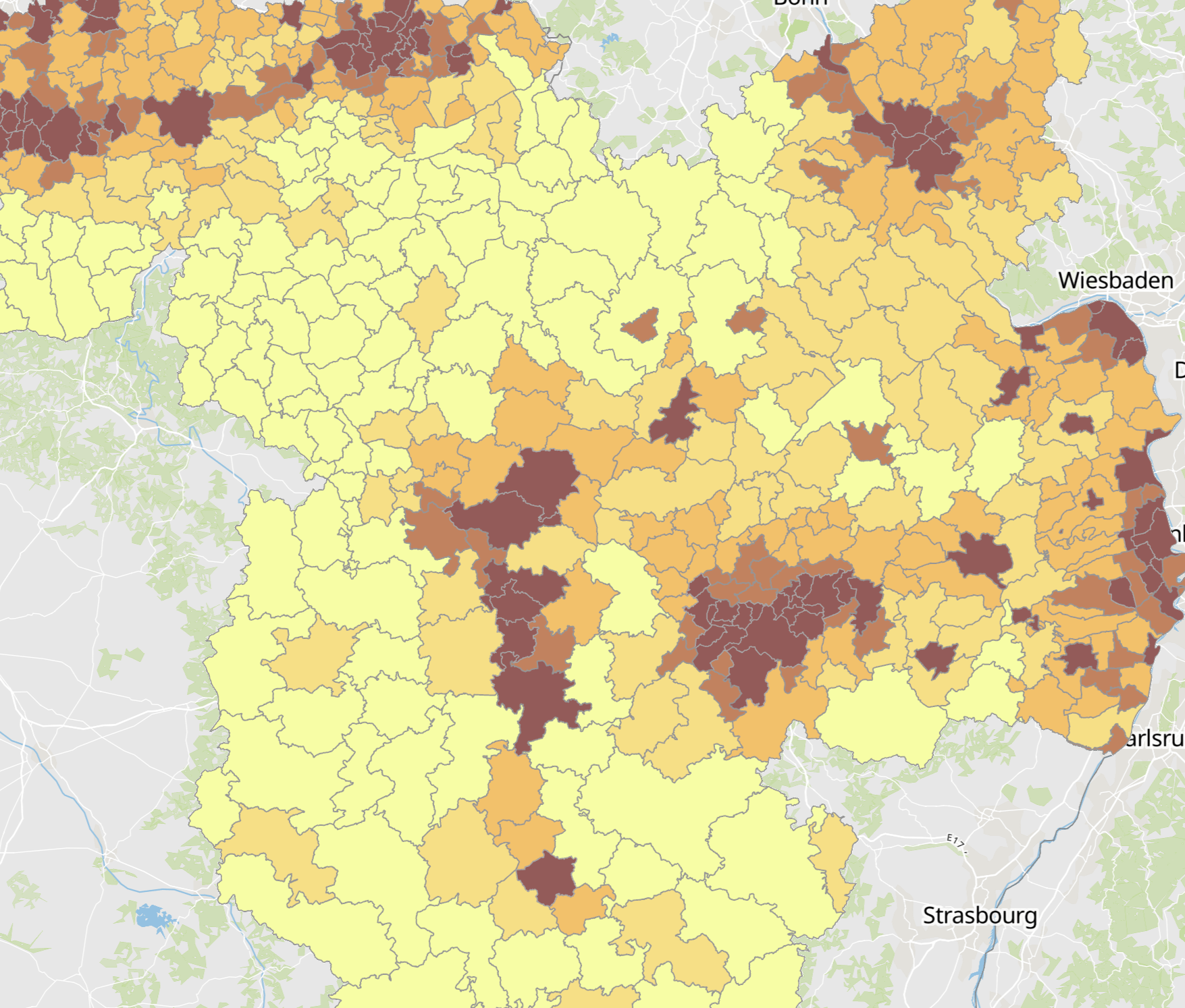
Densité de la population 2024
Population density 2024
Bevölkerungsdichte 2024
- Densité de la population 2024 (habitants par km²). Date de référence: 01.01.2024 (Luxembourg et Wallonie), 31.12.2023 (Rhénanie-Palatinat et Sarre), 01.01.2022 (Lorraine)
- Unités territoriales: communes (Sarre, Wallonie), cantons (Luxembourg), EPCI (Lorraine), Verbandsgemeinden et verbandsfreie Städte und Gemeinden (Rheinland-Pfalz)
- Sources des données statistiques: DATer, INSEE Grand Est, IWEPS, Région Grand Est, STATEC, Statistisches Landesamt Rheinland-Pfalz, Statistisches Landesamt Saarland. Harmonisation: SIG-GR / GIS-GR 2025
- Sources des données géographiques: GeoBasis-DE / BKG, IGN France, NGI-Belgium, ACT Luxembourg. Harmonisation: SIG-GR / GIS-GR 2025
- Population density 2024 (inhabitants per km²). Reference date: 01.01.2024 (Luxembourg and Wallonia), 31.12.2023 (Rhineland-Palatinate and Saarland), 01.01.2022 (Lorraine)
- Territorial entities: municipalities (Saarland, Wallonie), cantons (Luxembourg), EPCI (Lorraine), Verbandsgemeinden and verbandsfreie Städte und Gemeinden (Rheinland-Pfalz)
- Statistical data sources: DATer, INSEE Grand Est, IWEPS, Région Grand Est, STATEC, Statistisches Landesamt Rheinland-Pfalz, Statistisches Landesamt Saarland. Harmonization: SIG-GR / GIS-GR 2025
- Geodata sources: GeoBasis-DE / BKG, IGN France, NGI-Belgium, ACT Luxembourg. Harmonization: SIG-GR / GIS-GR 2025
- Bevölkerungsdichte 2024 (Einwohner je km²). Stichtag: 01.01.2024 (Luxemburg und Wallonie), 31.12.2023 (Rheinland-Pfalz und Saarland), 01.01.2022 (Lothringen)
- Gebietseinheiten: Gemeinden (Saarland, Wallonie), Kantone (Luxemburg), EPCI (Lorraine), Verbandsgemeinden und verbandsfreie Städte und Gemeinden (Rheinland-Pfalz)
- Quellen der statistischen Daten: DATer, INSEE Grand Est, IWEPS, Région Grand Est, STATEC, Statistisches Landesamt Rheinland-Pfalz, Statistisches Landesamt Saarland. Harmonisierung: SIG-GR / GIS-GR 2025
- Quellen der Geodaten: GeoBasis-DE / BKG, IGN France, NGI-Belgium, ACT Luxembourg. Harmonisierung: SIG-GR / GIS-GR 2025
Simple
-
Date (Creation)Datumsangaben (Erstellung)Date (Création)
- 2025-06-12T00:00:00
-
Citation identifierIdentifikatorIdentificateur
- / 93569c33-a975-4885-9896-626cff07cfa0
-
Presentation formPräsentationsformForme de la présentation
-
Digital mapDigitale KarteCarte numérique
-
StatusBearbeitungsstatusEtat
-
CompletedAbgeschlossenFinalisé
- Point of contact
-
Organisation name Individual name Electronic mail address Role SIG-GR - Ministère du Logement et de l'Aménagement du territoire - Département de l'aménagement du territoire
Bamdad Goudarzi
AuthorAutorAuteur
-
Maintenance and update frequencyÜberarbeitungsintervallFréquence de mise à jour
-
As neededBei BedarfLorsque nécessaire
- Keywords
-
-
Population, densité, commune, EPCI
Population, density, municipality
Bevölkerung, Dichte, Gemeinde
-
-
Entités dans la Grande Région
-
-
Grande Région
Greater Region
Großregion
-
-
gis-gr.eu themes
-
-
Démographie
Demography
Demografie
-
-
gis-gr.eu structure
-
-
Démographie>Densité de population
Demography>Population density
Demografie>Bevölkerungsdichte
-
- Keywords
-
-
gis-gr.eu
gis-gr.eu
gis-gr.eu
-
-
Access constraintsZugriffseinschränkungenContraintes d'accès
-
Other restrictionsBenutzerdefinierte EinschränkungenAutres restrictions
-
Spatial representation typeRäumliche DarstellungsartType de représentation spatiale
-
VectorVektorVecteur
-
DenominatorMaßstabszahlDénominateur de l'échelle
- 250000
-
LanguageSpracheLangue de la ressource
- English
-
LanguageSpracheLangue de la ressource
- Deutsch
-
LanguageSpracheLangue de la ressource
- Français
-
Character setZeichensatzEncodage des caractères
-
UTF8Utf8Utf8
-
Topic categoryISO-ThematikCatégorie ISO
-
-
SocietyGesellschaftSociété
-
))
-
Reference system identifierIdentifikator des ReferenzsystemsNom du système de référence
- EPSG / http://www.opengis.net/def/crs/EPSG/0/3857
- Distribution format
-
Name Version JPEG
SHAPE
PDF
Digital transfer options
Digitale Transferoptionen
Options de transfert numérique
- OnLine resource
-
Protocol Linkage Name WWW:LINK-1.0-http--samples
http://g-o.lu/gg/z9Mz Carte interactive
Interactive map
Interaktive Karte
OGC:WMS-1.3.0-http-get-map
https://ws.geoportail.lu/wss/service/GR_Pop_density_WMS/guest Pop_density_2024_infra
OGC:WFS
https://ws.geoportail.lu/wss/service/GR_Pop_density_WFS/guest Pop_density:Pop_density_2024_infra
WWW:LINK-1.0-http--link
https://data.public.lu/fr/datasets/population-density-2024/ Open data
Open data
Open data
Metadata
-
File identifierMetadatensatzidentifikatorIdentifiant de la fiche
- 93569c33-a975-4885-9896-626cff07cfa0 XML
-
Metadata languageSpracheLangue
- Français
-
Character setZeichensatzJeu de caractères
-
UTF8Utf8Utf8
-
Hierarchy levelHierarchieebeneType de ressource
-
DatasetDatenbestandJeu de données
- Hierarchy level name
-
dataset
-
Date stampDatumDate des métadonnées
- 2025-07-21T12:59:46
- Metadata standard name
-
ISO 19115:2003/19139
- Metadata standard version
-
1.0
- Metadata author
-
Organisation name Individual name Electronic mail address Role SIG-GR - Ministère du Logement et de l'Aménagement du territoire - Département de l'aménagement du territoire
Bamdad Goudarzi
Point of contactAnsprechpartnerPoint de contact
- Other language
-
Language Character encoding EnglishEnglischAnglaisUTF8Utf8Utf8GermanDeutschAllemandUTF8Utf8Utf8FrenchFranzösischFrançaisUTF8Utf8Utf8
)))