 Catalogue DataGrandEst
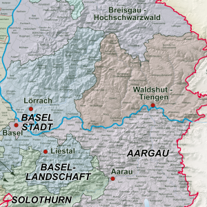
Area of the Upper Rhine Conference - 2013 (Poster A0)
This map shows the administrative borders of the Upper Rhine area. It has been designed to be printed on A0 posters.
Simple
- Date (Creation)
- 2013-01-01
- Date (Publication)
- 2022-06-20
- Citation identifier
- 01_2013_0185
- Status
- Completed
- Point of contact
-
Organisation name Individual name Electronic mail address Role GeoRhena
GeoRhena
Processor
- Maintenance and update frequency
- Not planned
- Keywords
-
-
Map
-
- Keywords
-
-
Upper Rhine
-
-
GEMET - Concepts, version 2.4
-
-
administrative boundary
-
geography
-
co-operation policy
-
- Use limitation
-
Licence CC BY
- Access constraints
- Other restrictions
- Use constraints
- Other restrictions
- Other constraints
-
No other limitation
- Denominator
- 100000
- Language
- Français
- Character set
- UTF8
- Topic category
-
- Boundaries
- Begin date
- 2013-01-01
- End date
- 2013-12-31
N
S
E
W
))
- Distribution format
-
Name Version PDF Map
-
Digital transfer options
- OnLine resource
-
Protocol Linkage Name WWW:DOWNLOAD-1.0-http--download
https://www.georhena.eu/sites/default/files/Cartes/01_2013_0185.pdf Pdf Download
Metadata
- File identifier
- 974207cb-9cf6-4611-89ed-0a173ef4edee XML
- Metadata language
- Français
- Character set
- UTF8
- Hierarchy level
- staticMap
- Hierarchy level name
-
Carte statique
- Date stamp
- 2022-06-20T12:47:29
- Metadata standard name
-
ISO 19115:2003/19139
- Metadata standard version
-
1.0
- Metadata author
-
Organisation name Individual name Electronic mail address Role GeoRhena: Geographical Information System of the Upper Rhine
Author
- Other language
-
Language Character encoding German UTF8 English UTF8 French UTF8
)))
