Catalogue DataGrandEst
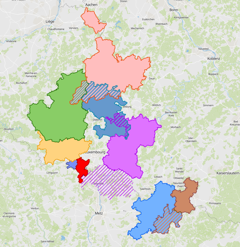
Cross-border functional areas 2025
- Cross-border functional areas defined within the Interreg programme of the Greater Region in 2025.
- Sources: Entwicklungskonzept Oberes Moseltal (EOM), Eurodistrict SaarMoselle, GECT Alzette-Belval, MLOGAT-DATer, Idelux, Eifel-Ostbelgien-Eislek (EOE), Mëllerdall-Our-Südeifel (MOSE), TNT Chiers Alzette, Parc archéologique européen - Europäischer Kulturpark Bliesbruck-Reinheim. Harmonisation: SIG-GR 2025
Simple
- Date (Creation)
- 2025-03-05T00:00:00
- Citation identifier
- / 9cbc3c9a-b621-4137-af54-d5ef00b0361c
- Presentation form
- Digital map
- Status
- Completed
- Point of contact
-
Organisation name Individual name Electronic mail address Role SIG-GR - Ministère du Logement et de l'Aménagement du territoire - Département de l'aménagement du territoire
Bamdad Goudarzi
Author
- Maintenance and update frequency
- As needed
- Keywords
-
-
Spatial planning, cross-border functional areas
-
-
Entités dans la Grande Région
-
-
Greater Region
-
-
gis-gr.eu themes
-
-
Spatial planning
-
-
gis-gr.eu structure
-
-
Spatial planning>Cross-border functional areas
-
- Keywords
-
-
gis-gr.eu
-
- Access constraints
- Other restrictions
- Spatial representation type
- Vector
- Denominator
- 0
- Language
- Français
- Language
- English
- Language
- ltz
- Character set
- UTF8
- Topic category
-
- Planning cadastre
))
- Reference system identifier
- EPSG / http://www.opengis.net/def/crs/EPSG/0/3857
- Distribution format
-
Name Version SHAPE
PDF
JPEG
Digital transfer options
- OnLine resource
-
Protocol Linkage Name OGC:WMS-1.3.0-http-get-map
https://ws.geoportail.lu/wss/service/GR_Spatial_planning_WMS/guest Crossborder_functional_areas_Interreg_2025
WWW:LINK-1.0-http--samples
http://g-o.lu/gg/OTWx Interactive map
OGC:WFS
https://ws.geoportail.lu/wss/service/GR_Spatial_planning_WFS/guest Spatial_planning:Crossborder_functional_areas_Interreg_2025
WWW:LINK-1.0-http--link
https://data.public.lu/fr/datasets/cross-border-functional-areas-2025/ Open data
WWW:LINK-1.0-http--related
https://www.sig-gr.eu/de/cartes-thematiques/amenagement-territoire/zones-fonctionnelles-transfrontalieres/2025.html Link to the description of the map - DE version
WWW:LINK-1.0-http--related
https://www.sig-gr.eu/fr/cartes-thematiques/amenagement-territoire/zones-fonctionnelles-transfrontalieres/2025.html Link to the description of the map - FR version
Metadata
- File identifier
- 9cbc3c9a-b621-4137-af54-d5ef00b0361c XML
- Metadata language
- Français
- Character set
- UTF8
- Hierarchy level
- Dataset
- Hierarchy level name
-
dataset
- Date stamp
- 2025-04-04T14:38:13
- Metadata standard name
-
ISO 19115:2003/19139
- Metadata standard version
-
1.0
- Metadata author
-
Organisation name Individual name Electronic mail address Role SIG-GR - Ministère du Logement et de l'Aménagement du territoire - Département de l'aménagement du territoire
Bamdad Goudarzi
Point of contact
- Other language
-
Language Character encoding English UTF8 German UTF8 French UTF8
)))