 Catalogue DataGrandEst
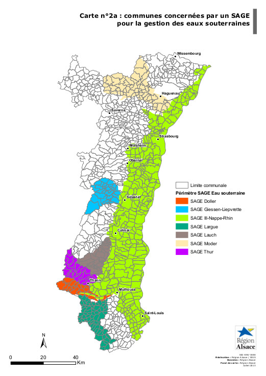
CARTE - Communes concernées par un SAGE - pour la gestion des eaux souterraines
Actuellement 7 SAGE sont en cours d’élaboration ou approuvés en Alsace. Chaque SAGE définit un programme d’actions pour la préservation des ressources en eau sur son territoire. Le périmètre « eaux superficielles » d’un SAGE correspond au territoire où s’appliquent les dispositions relatives aux cours et aux zones humides. Le périmètre « eaux souterraines » d’un SAGE correspond au territoire où s’appliquent les dispositions relatives aux aquifères souterrains.
Simple
- Date (Publication)
- 2013-05-01
- Presentation form
- Digital map
- Point of contact
-
Organisation name Individual name Electronic mail address Role Région Alsace
Point of contact
- Theme
-
-
CARTE
-
- Theme
-
-
SAGE
-
- Denominator
- 250000
- Language
- Français
N
S
E
W
))
- Distribution format
-
Name Version PDF
1.7
Digital transfer options
- OnLine resource
-
Protocol Linkage Name WWW:DOWNLOAD-1.0-http--download
https://www.datagrandest.fr/metadata/region-grand-est/CARTES/FR-236700019-CARTE-SIG-ENV-3388-2A/SIG-ENV-3388-2A.pdf SIG-ENV-3388-2A.pdf
OnLine resource
No information provided.
Metadata
- File identifier
- FR-236700019-CARTE-SIG-ENV-3388-2A XML
- Metadata language
- Français
- Character set
- UTF8
- Hierarchy level
- Dataset
- Date stamp
- 2013-08-02T11:10:49
- Metadata standard name
-
ISO 19115:2003/19139
- Metadata standard version
-
1.0
- Metadata author
-
Organisation name Individual name Electronic mail address Role Région Alsace
Sacha Weber
Point of contact
)))