 Catalogue DataGrandEst
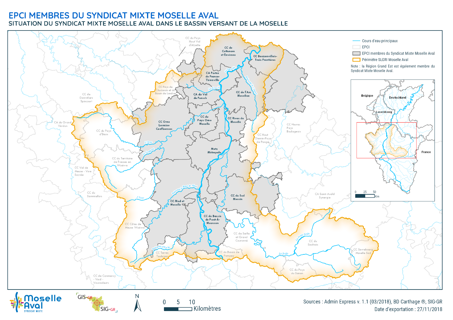
Perimetre de la SLGRI Moselle Aval
La stratégie locale de gestion des risques d’inondation (SLGRI) Moselle aval concerne le TRI "Metz Thionville Pont-à-Mousson"
La stratégie locale a pour Perimetre l’ensemble du bassin versant de la Moselle en aval de la confluence de la Meurthe, qui s’étend sur les départements de Moselle, Meurthe-et-Moselle et Meuse.
Elle fixe quatre objectifs de prévention des inondations, à mettre en oeuvre dans un délai de six ans :
- Développer une gouvernance adaptée au risque à l’échelle du bassin versant
- Améliorer la connaissance
- Améliorer l’alerte et la gestion de crise
- Prendre en compte le risque inondation dans l’urbanisme.
Simple
- Date (Creation)
- 2024-02-01
- Date (Publication)
- Date (Publication)
- Citation identifier
- FR_20007754300029_SLGRI_MA
- Point of contact
-
Organisation name Individual name Electronic mail address Role Syndicat Mixte Moselle Aval
Point of contact
- Maintenance and update frequency
- Not planned
- Classification
- Unclassified
- Access constraints
- Other restrictions
- Use limitation
-
Données sous licence Etalab v2 (cf. https://www.etalab.gouv.fr/wp-content/uploads/2017/04/ETALAB-Licence-Ouverte-v2.0.pdf)
- Use limitation
-
Sources: Syndicat Mixte Moselle Aval
Resource constraints
- Classification
- Unclassified
- Use constraints
- License
- Other constraints
-
Pas de restriction d'accès public
- Spatial representation type
- Vector
- Distance
- 2
- Denominator
- 200000
- Language
- Français
- Character set
- UTF8
- Description
-
Bassin versant de la Moselle aval
))
- Theme
-
-
Inondations
-
SLGRI
-
Moselle Aval
-
données ouvertes
-
-
DataGrandEst - Thèmes open data, version 1.0 (dge-tod)
-
-
ADMINISTRATION ET ACTION PUBLIQUE
-
EAU ET HYDROGRAPHIE
-
NUISANCES DECHETS ET RISQUES
-
AMENAGEMENT ET URBANISME
-
- Reference system identifier
- EPSG / RGF93 – Lambert 93 (EPSG:2154)
- Distribution format
-
Name Version SHP
Non définie
Digital transfer options
- OnLine resource
-
Protocol Linkage Name OGC:WMS
https://www.datagrandest.fr/geoserver/smma/wms PERIMETRE DE LA SLGRI MOSELLE AVAL
OGC:WFS
https://www.datagrandest.fr/geoserver/smma/ows PERIMETRE DE LA SLGRI MOSELLE AVAL
WWW:DOWNLOAD-1.0-http--download
https://www.datagrandest.fr/metadata/smma/FR_20007754300029_SLGRI_MA/perimetre_slgri_moselle_aval.zip perimetre_slgri_moselle_aval.zip
- Hierarchy level
- Dataset
- Date
- Statement
-
Emprise générée à partir de la BD TOPAGE 2019 de l'IGN
Metadata
- File identifier
- FR_20007754300029_SLGRI_MA XML
- Metadata language
- Français
- Character set
- UTF8
- Hierarchy level
- Dataset
- Date stamp
- 2026-04-13T07:43:19.870025Z
- Metadata standard name
-
ISO 19115/19139
- Metadata standard version
-
Cor 1:2006
- Metadata author
-
Organisation name Individual name Electronic mail address Role Syndicat Mixte Moselle Aval
Point of contact
)))