 Catalogue DataGrandEst
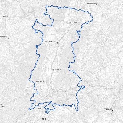
Interreg Upper Rhine programming area 2021-2027
The Upper Rhine region stretches along 350 kilometres of the Rhine on the border between France, Germany and Switzerland. The entire area comprises four sub-regions: Alsace, the southern and south-western Palatinate, part of Baden and north-western Switzerland with its five cantons. In the 2021-2027 funding period, the Interreg Upper Rhine programme area differs from that of the 2014-2020 period. In the north-west, the independent city of Pirmasens is now added on the German side in the Southern Palatinate region.
A project is eligible for funding if it involves at least two partners, who must come from two of the three countries that make up the programme area. The headquarters of the institution acting as project sponsor must be located in this programme area.
Simple
- Alternate title
-
Upper Rhine Interreg Perimeter
- Date (Creation)
- 2025-06-01
- Date (Publication)
- 2025-06-20
- Citation identifier
- zone_interreg_RS
- Status
- Completed
- Point of contact
-
Organisation name Individual name Electronic mail address Role GeoRhena
GeoRhena
Point of contact
- Maintenance and update frequency
- Annually
- Keywords
-
-
Open-Data
-
URP
-
- Place
-
-
Upper Rhine
-
- Use limitation
-
© GeoRhena
- Access constraints
- Other restrictions
- Use constraints
- Other restrictions
- Other constraints
-
No other limitation
- Spatial representation type
- Vector
- Denominator
- 100000
- Language
- Français
- Character set
- UTF8
- Topic category
-
- Boundaries
- Begin date
- 2021-01-01
- End date
- 2027-12-31
))
- Distribution format
-
Name Version SHP GeoData
-
Digital transfer options
- OnLine resource
-
Protocol Linkage Name OGC:WMS
https://geoportal.georhena.eu/geoserver/boundaries/ows zone_interreg_RS
OGC:WFS
https://geoportal.georhena.eu/geoserver/boundaries/ows zone_interreg_RS
WWW:DOWNLOAD-1.0-ftp--download
https://geoportal.georhena.eu/geoserver/boundaries/ows?request=GetFeature&service=WFS&typeName=zone_interreg_RS&version=1.0.0&outputFormat=SHAPE-ZIP Téléchargement du Shapefile Téléchargement du Shapefile
WWW:LINK-1.0-http--link
https://www.interreg-rhin-sup.eu/ Interreg Upper Rhine programme website
- Hierarchy level
- Dataset
- Statement
-
GeoRhena - 2025
Metadata
- File identifier
- a33bbb40-500e-46fa-be30-f3c0b55bda8c XML
- Metadata language
- Français
- Character set
- UTF8
- Hierarchy level
- Dataset
- Date stamp
- 2025-10-06T07:28:23.700912Z
- Metadata standard name
-
ISO 19115:2003/19139
- Metadata standard version
-
1.0
- Metadata author
-
Organisation name Individual name Electronic mail address Role GeoRhena: Geographical Information System of the Upper Rhine
Point of contact
- Other language
-
Language Character encoding German UTF8 English UTF8 French UTF8
)))
