• Catalogue DataGrandEst
  •   Rechercher
  •   Carte

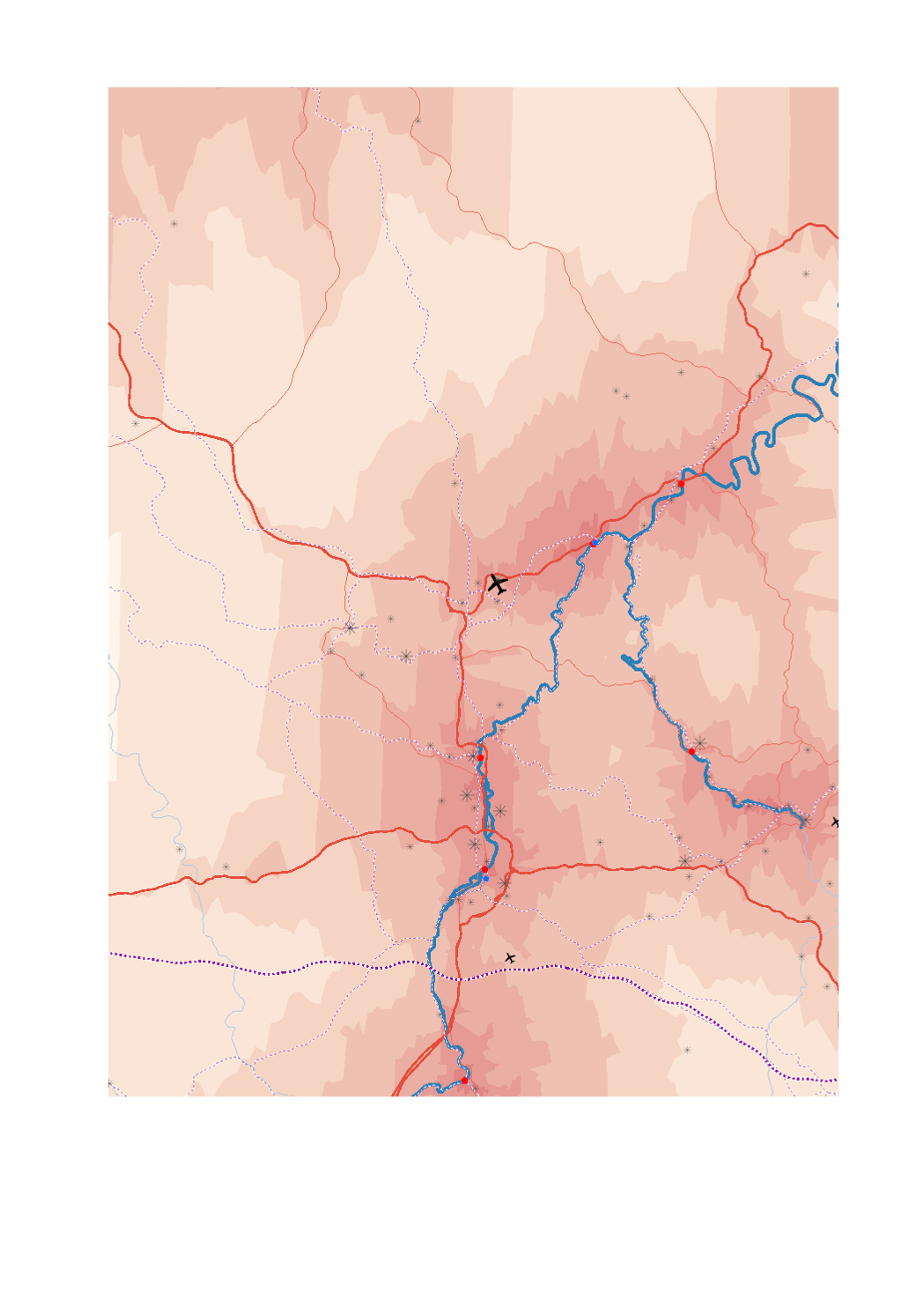
Infrastructures pour le transport de marchandises en 2018: échelle suprarégionale

- Trafic de fret (en tonnes) par aéroport en 2017

- Plateformes trimodales fluviale-route-ferroviaire

- Ports RTE-T

- Aire d'entrepôts commerciaux et industriels (>25ha)

- Lignes ferroviaires à grande vitesse

- Lignes ferroviaires RTE-T

- Routes principales (réseau central RTE-T)

- Routes secondaires (réseau global RTE-T)

- Voies navigables

- Liaisons maritimes

- Accessibilité routière aux plateformes multimodales en minutes (isochrones)


- Sources: GISCO 2017; SIG-GR / GIS-GR 2017; European Environment Agency - 2012; OSM-2017; European Commission 2017; EUROSTAT 2018. Harmonisation: CREAT-UCL 2018

Simple

Date (Création)
2019-08-05T00:00:00
Identificateur
/ a76c3f5d-41ca-4f74-8efa-994a630276f9
Forme de la présentation
Carte numérique
Etat
Finalisé
Contact pour la ressource
Nom de l'organisation Nom de la personne Adresse e-mail Rôle

SIG-GR - Ministère de l'Energie et de l'Aménagement du territoire - Département de l'aménagement du territoire

Thierry Hengen

thierry.hengen@mat.etat.lu

Auteur
Fréquence de mise à jour
Lorsque nécessaire
Mots clés
  • infrastructure, transport, marchandises, suprarégional

Entités dans la Grande Région

  • Grande Région

gis-gr.eu themes

  • Transports

gis-gr.eu structure

  • Transports>Infrastructures de transport

Mots clés
  • gis-gr.eu

Contraintes d'accès
Autres restrictions
Type de représentation spatiale
Vecteur
Dénominateur de l'échelle
250000
Langue de la ressource
English
Langue de la ressource
Français
Langue de la ressource
Deutsch
Encodage des caractères
Utf8
Catégorie ISO
  • Infrastructures de transport
N
S
E
W


Nom du système de référence
EPSG / http://www.opengis.net/def/crs/EPSG/0/3857
Format (encodage)
Nom Version

PDF

SHAPE

JPEG

Options de transfert numérique

Ressource en ligne
Protocole Adresse Internet Nom

WWW:LINK-1.0-http--samples

https://map.gis-gr.eu/theme/transport?version=3&zoom=8&X=667917&Y=6394482&lang=en&layers=1867&opacities=1&bgLayer=basemap_2015_global

Carte interactive

WWW:LINK-1.0-http--link

https://data.public.lu/en/datasets/supraregional-freight-infrastructure-2018

Open data

OGC:WMS-1.3.0-http-get-map

https://ws.geoportail.lu/wss/service/GR_Transport_infrastructures_WMS/guest

Airport_freight_2017

OGC:WMS-1.3.0-http-get-map

https://ws.geoportail.lu/wss/service/GR_Transport_infrastructures_WMS/guest

Commercial_industrial_warehouse_area_2018

OGC:WMS-1.3.0-http-get-map

https://ws.geoportail.lu/wss/service/GR_Transport_infrastructures_WMS/guest

High_speed_rail_2018

OGC:WMS-1.3.0-http-get-map

https://ws.geoportail.lu/wss/service/GR_Transport_infrastructures_WMS/guest

Isochrones_access_multimodal_platforms_2018

OGC:WMS-1.3.0-http-get-map

https://ws.geoportail.lu/wss/service/GR_Transport_infrastructures_WMS/guest

Maritime_links_2018

OGC:WMS-1.3.0-http-get-map

https://ws.geoportail.lu/wss/service/GR_Transport_infrastructures_WMS/guest

Multimodal_hub_2018

OGC:WMS-1.3.0-http-get-map

https://ws.geoportail.lu/wss/service/GR_Transport_infrastructures_WMS/guest

Navigable_waterways

OGC:WMS-1.3.0-http-get-map

https://ws.geoportail.lu/wss/service/GR_Transport_infrastructures_WMS/guest

Railway_TENtec_2018

OGC:WMS-1.3.0-http-get-map

https://ws.geoportail.lu/wss/service/GR_Transport_infrastructures_WMS/guest

Ports_TENtec_2018

OGC:WMS-1.3.0-http-get-map

https://ws.geoportail.lu/wss/service/GR_Transport_infrastructures_WMS/guest

Road_comprehensive_TENtec_2018

OGC:WMS-1.3.0-http-get-map

https://ws.geoportail.lu/wss/service/GR_Transport_infrastructures_WMS/guest

Road_core_TENtec_2018

OGC:WFS

https://ws.geoportail.lu/wss/service/GR_Transport_infrastructures_WFS/guest

Transport_infrastructures:Airport_freight_2017

OGC:WFS

https://ws.geoportail.lu/wss/service/GR_Transport_infrastructures_WFS/guest

Transport_infrastructures:Commercial_industrial_warehouse_area_2018

OGC:WFS

https://ws.geoportail.lu/wss/service/GR_Transport_infrastructures_WFS/guest

Transport_infrastructures:Ports_TENtec_2018

OGC:WFS

https://ws.geoportail.lu/wss/service/GR_Transport_infrastructures_WFS/guest

Transport_infrastructures:Multimodal_hub_2018

OGC:WFS

https://ws.geoportail.lu/wss/service/GR_Transport_infrastructures_WFS/guest

Transport_infrastructures:Railway_TENtec_2018

OGC:WFS

https://ws.geoportail.lu/wss/service/GR_Transport_infrastructures_WFS/guest

Transport_infrastructures:High_speed_rail_2018

OGC:WFS

https://ws.geoportail.lu/wss/service/GR_Transport_infrastructures_WFS/guest

Transport_infrastructures:Navigable_waterways

OGC:WFS

https://ws.geoportail.lu/wss/service/GR_Transport_infrastructures_WFS/guest

Transport_infrastructures:Maritime_links_2018

OGC:WFS

https://ws.geoportail.lu/wss/service/GR_Transport_infrastructures_WFS/guest

Transport_infrastructures:Isochrones_access_multimodal_platforms_2018

OGC:WFS

https://ws.geoportail.lu/wss/service/GR_Transport_infrastructures_WFS/guest

Transport_infrastructures:Road_core_TENtec_2018

OGC:WFS

https://ws.geoportail.lu/wss/service/GR_Transport_infrastructures_WFS/guest

Transport_infrastructures:Road_comprehensive_TENtec_2018

Métadonnées

Identifiant de la fiche
a76c3f5d-41ca-4f74-8efa-994a630276f9 XML
Langue
Français
Jeu de caractères
Utf8
Type de ressource
Jeu de données
Nom du niveau de hiérarchie

dataset

Date des métadonnées
2025-01-13T09:23:49
Nom du standard de métadonnées

ISO 19115:2003/19139

Version du standard de métadonnées

1.0

Contact
Nom de l'organisation Nom de la personne Adresse e-mail Rôle

SIG-GR - Ministère de l'Energie et de l'Aménagement du territoire - Département de l'aménagement du territoire

Thierry Hengen

thierry.hengen@mat.etat.lu

Point de contact
Autre langue
LanguageCode CharacterEncoding
Anglais Utf8
Allemand Utf8
Français Utf8


Aperçus

Étendue spatiale

Mots clés

infrastructure, transport, marchandises, suprarégional
gis-gr.eu structure

Transports>Infrastructures de transport
gis-gr.eu themes

Transports


Fourni par

Partager

Lien vers le catalogue
Consultez l'intégralité des métadonnées et accédez à la donnée.