Catalogue DataGrandEst
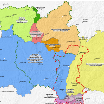
National/regional/cantonal spatial planning documents for the Greater Region and the Upper Rhine - 2024
Map showing the boundaries of the various spatial planning documents in the Greater Region and the Upper Rhine, at national (Luxembourg), regional (Belgium, France and Germany) and cantonal (Switzerland) level.
Simple
- Date (Creation)
- 2024-06-01
- Date (Publication)
- 2024-06-10
- Citation identifier
- Amenag_regional_Raumplanung_Landesebene_GR_RS_2024
- Status
- Completed
- Point of contact
-
Organisation name Individual name Electronic mail address Role GeoRhena
GeoRhena
Processor SIG-GR - Ministère du Logement et de l'Aménagement du territoire - Département de l'aménagement du territoire
Processor
- Maintenance and update frequency
- Not planned
- Keywords
-
-
Map
-
- Keywords
-
-
Upper Rhine
-
Greater Region
-
-
GEMET - Concepts, version 2.4
-
-
administrative boundary
-
geography
-
co-operation policy
-
land setup
-
- Use limitation
-
Licence CC BY
- Access constraints
- Other restrictions
- Use constraints
- Other restrictions
- Other constraints
-
No other limitation
- Denominator
- 1000000
- Language
- Français
- Character set
- UTF8
- Topic category
-
- Planning cadastre
- Begin date
- 2023-01-01
- End date
- 2024-12-31
- Distribution format
-
Name Version PDF Map
-
Digital transfer options
- OnLine resource
-
Protocol Linkage Name WWW:DOWNLOAD-1.0-http--download https://www.georhena.eu/sites/default/files/Cartes/Amenag_regional_Raumplanung_Landesebene_GR_RS_2024.pdf Pdf Download
WWW:LINK-1.0-http--link https://geocatalogue.gis-gr.eu/geonetwork/gis-gr/fre/catalog.search#/metadata/d6f72182-6d33-4b31-bdc1-79add68bc564 Additional metadata sheet
- Statement
-
Sources: GeoRhena, MDI Rheinland-Pfalz, MIBS Saarland, Ministerium der Deutschsprachigen Gemeinschaft, MLOGAT-DATer Luxembourg, Région Grand Est, Service public de Wallonie, Verband Rhein-Neckar 2024. Harmonization: GIS-GR 2024
Metadata
- File identifier
- aaefb405-5646-4a4f-a12c-c4bcfc93461a XML
- Metadata language
- Français
- Character set
- UTF8
- Hierarchy level
- staticMap
- Hierarchy level name
-
Carte statique
- Date stamp
- 2024-06-10T14:09:17.900556Z
- Metadata standard name
-
ISO 19115:2003/19139
- Metadata standard version
-
1.0
- Metadata author
-
Organisation name Individual name Electronic mail address Role GeoRhena: Geographical Information System of the Upper Rhine
Author
- Other language
-
Language Character encoding German UTF8 English UTF8 French UTF8