 Catalogue DataGrandEst
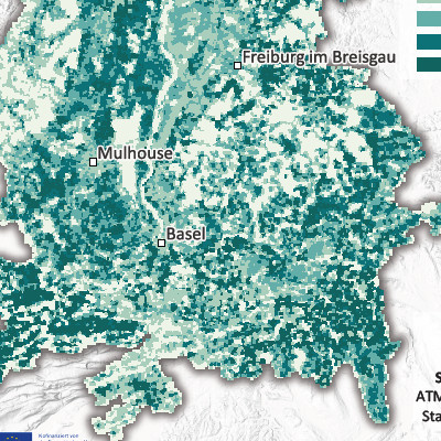
Emissions d’ammoniac par maille de 500m dans le Rhin supérieur (2021)
Ammonia emissions per 500 m grid cell in the Upper Rhine region (2021)
Ammoniak-Emissionen pro 500m Rasterzelle am Oberrhein (2021)
Produite dans le cadre du projet Interreg Rhin Supérieur Atmo-Rhena PLUS, cette carte représente les émissions d’ammoniac (NH3) sur le territoire du Rhin supérieur en 2021.
La limitation des émissions de polluants atmosphériques est le levier le plus important pour réduire les concentrations de polluants dans l'atmosphère.
L'ammoniac est un composé gazeux dans l'atmosphère. A très fortes concentrations, ce gaz devient irritant pour les voies respiratoires et les yeux. Aux concentrations habituellement rencontrées en air ambiant ses effets sanitaires directs sont faibles, à la différence des effets environnementaux engendrés (l’ammoniac joue un rôle majeur dans l'acidification et l'eutrophisation des milieux naturels). De plus, l’ammoniac réagit avec d’autres substances présentes dans l’atmosphère pour former des particules fines secondaires.
L'ammoniac est majoritairement émis par l'agriculture, principalement par les épandages d’engrais et les déjections animales de l'élevage. En zone urbaine, le secteur résidentiel, la gestion des déchets, certaines industries ou encore le transport routier sont également responsables d’émissions d’ammoniac.
Cette carte montre la répartition des émissions annuelles d’ammoniac dans le fossé rhénan supérieur. Ces émissions sont souvent liées aux pratiques agricoles, notamment l’élevage intensif et l’épandage d’engrais organiques. Les piémonts présentent souvent a minima des niveaux intermédiaires, traduisant une activité agricole modérée. Les grandes agglomérations apparaissent comme des zones relativement faibles en émissions.
La carte statique sous format PDF est disponible à l'échelle de mailles de 500m. Les données sont accessibles en opendata uniquement à l'échelle des EPCI, Kreis et Cantons.
Produced as part of the Interreg Upper Rhine Atmo-Rhena PLUS project, this map shows ammonia (NH3) emissions in the Upper Rhine region in 2021.
Limiting air pollutant emissions is the most important lever for reducing pollutant concentrations in the atmosphere.
Ammonia is a gaseous compound in the atmosphere. At very high concentrations, this gas irritates the respiratory tract and eyes. At concentrations typically found in ambient air, its direct health effects are low, unlike its environmental effects (ammonia plays a major role in the acidification and eutrophication of natural environments). In addition, ammonia reacts with other substances in the atmosphere to form secondary fine particles.
Ammonia is mainly emitted by agriculture, primarily through fertiliser spreading and animal waste from livestock farming. In urban areas, the residential sector, waste management, certain industries and road transport are also responsible for ammonia emissions.
This map shows the distribution of annual ammonia emissions in the Upper Rhine Valley. These emissions are often linked to agricultural practices, particularly intensive livestock farming and the spreading of organic fertilisers. The foothills often have at least intermediate levels, reflecting moderate agricultural activity. Large urban areas appear to be relatively low in emissions.
The static map in PDF format is available at a scale of 500m. The data is accessible as open data only at the scale of EPCI, Kreis and Cantons.
Diese Karte wurde im Rahmen des Interreg-Projekts Oberrhein Atmo-Rhena PLUS erstellt und stellt die Ammoniakemissionen am Oberrheingebiet dar.
Die Begrenzung der Luftschadstoffemissionen ist der wichtigste Hebel, um die Schadstoffkonzentrationen in der Atmosphäre zu verringern.
Ammoniak ist eine gasförmige Verbindung in der Atmosphäre, die bei sehr hohen Konzentrationen die Atemwege und die Augen reizen kann. Bei den üblichen Konzentrationen in der Umgebungsluft sind die direkten gesundheitlichen Auswirkungen gering, jedoch trägt Ammoniak auch in geringen Konzentration zur Eutrophierung und Versauerung natürlicher Ökosysteme bei. Des Weiteren reagiert Ammoniak mit anderen Substanzen in der Atmosphäre und bildet sekundäre Feinstaubpartikel.
Ammoniak wird hauptsächlich von der Landwirtschaft freigesetzt, insbesondere durch Düngemittel und tierische Ausscheidungen aus der Viehzucht. Weitere Ammoniakquellen finden sich im städtischen Bereich, wie dem Straßenverkehr, der Holzverbrennung, der Abfallwirtschaft und verschiedenen Industriezweige.
Die Ammoniakemissionen auf der Karte entstehen häufig in der Landwirtschaft, insbesondere bei der intensiven Tierhaltung und der Ausbringung organischer Düngemittel. Die Vorgebirgsregionen weisen häufig mittlere Werte auf, was auf eine mäßige landwirtschaftliche Aktivität hinweist. In den großen Ballungsräume kommt es hingegen zu geringeren NH3-Emissionen.
Die statische Karte im PDF-Format ist im Maßstab 500 m verfügbar. Die Daten sind als Open Data nur im Maßstab der EPCI, Kreise und Kantone zugänglich.
Simple
-
Date (Creation)Datumsangaben (Erstellung)Date (Création)
- 2025-08-07
-
Date (Publication)Datumsangaben (Publikation)Date (Publication)
- 2025-11-07
-
Citation identifierIdentifikatorIdentificateur
- AtmoRhenaPlus_nh3_maille_500m
-
StatusBearbeitungsstatusEtat
-
CompletedAbgeschlossenFinalisé
- Point of contact
-
Organisation name Individual name Electronic mail address Role GeoRhena
GeoRhena
GeoRhena
Point of contactAnsprechpartnerPoint de contactATMO Grand Est
ATMO Grand Est
ATMO Grand Est
CustodianVerwalterGestionnaireLandesanstalt für Umwelt Baden-Württemberg (LUBW)
CustodianVerwalterGestionnaireLufthygieneamt beider Basel
CustodianVerwalterGestionnaireLandesamt für Umwelt Rheinland-Pfalz
CustodianVerwalterGestionnaireOffice de l'environnement - République et Canton du Jura
CustodianVerwalterGestionnaireDepartement Bau, Verkehr und Umwelt - Kanton Aargau
CustodianVerwalterGestionnaire
-
Maintenance and update frequencyÜberarbeitungsintervallFréquence de mise à jour
-
Not plannedNicht geplantNon planifiée
-
ThemeThemaThème
-
-
Rhin Supérieur
Upper Rhine
Oberrhein
-
Transfrontalier
Crossborder
Grenzüberschreitend
-
-
GEMET - Concepts, version 2.4
-
-
airairLuft
-
ammoniacammoniaAmmoniak
-
pollution de l'airair pollutionLuftverunreinigung
-
engraisfertiliserDüngemittel
-
trafic routierroad trafficStraßenverkehr
-
acidificationacidificationVersauerung
-
agricultureagricultureLandwirtschaft
-
élevageanimal husbandryTierhaltung
-
végétationvegetationVegetation
-
eutrophisationeutrophicationEutrophierung
-
dépôt de particules finesdeposited particulate matterAbgelagerte Partikel
-
-
Limitation d'utilisationUse limitationAnwendungseinschränkungen
-
Licence ODbL V1.0
CC-BY Licence ©OpenStreetMap contributors ©GeoRhena
CC-BY Lizenz ©OpenStreetMap contributors ©GeoRhena
-
Access constraintsZugriffseinschränkungenContraintes d'accès
-
Other restrictionsBenutzerdefinierte EinschränkungenAutres restrictions
-
Use constraintsNutzungseinschränkungenContraintes d'utilisation
-
Other restrictionsBenutzerdefinierte EinschränkungenAutres restrictions
-
Autres contraintesOther constraintsAndere Einschränkungen
-
Pas d'autre limitation
No other limitation
Keine andere Einschränkung
-
Spatial representation typeRäumliche DarstellungsartType de représentation spatiale
-
VectorVektorVecteur
-
DenominatorMaßstabszahlDénominateur de l'échelle
- 50000
-
LanguageSpracheLangue de la ressource
- Français
-
LanguageSpracheLangue de la ressource
- Deutsch
-
LanguageSpracheLangue de la ressource
- English
-
Character setZeichensatzEncodage des caractères
-
UTF8Utf8Utf8
-
Topic categoryISO-ThematikCatégorie ISO
-
-
EnvironmentUmweltEnvironnement
-
HealthGesundheitswesenSanté
-
- Begin date
- 2020-01-01
- End date
- 2021-12-31
))
Digital transfer options
Digitale Transferoptionen
Options de transfert numérique
- OnLine resource
-
Protocol Linkage Name OGC:WMS
https://portailsig.atmo-grandest.eu/server/services/Flux_Atmorhenaplus/atmo_rhena_plus_emi_nh3/MapServer/WMSServer 0
OGC:WFS
https://portailsig.atmo-grandest.eu/server/services/Flux_Atmorhenaplus/atmo_rhena_plus_emi_nh3/MapServer/WFSServer Emissions d'ammoniac
Ammonia Emmissions
Ammoniak-Emissionen
WWW:LINK-1.0-http--link
https://atmo-rhena.eu/ Portail Qualité de l’air du le Rhin supérieur
Upper Rhine Air Quality Portal
Luftqualitätsportal Oberrhein
WWW:DOWNLOAD-1.0-http--download
https://www.georhena.eu/sites/default/files/Cartes/Emi_nh3_cadastre_500m_A6.pdf Emissions d'ammoniac par maille de 500m
Ammonia emissions per 500m mesh
Ammoniak-Emissionen pro 500m Rasterzelle
WWW:LINK-1.0-http--link
https://www.atmo-grandest.eu/publications/atmo-rhena-plus-ammoniac-un-polluant-sous-surveillance Brochure de mesures de NH3 dans le Rhin supérieur
Brochure on NH3 measurements in the Upper Rhine
Broschüre zur NH3-Messung am Oberrhein
OnLine resource
Online
Ressource en ligne
Digital transfer options
Digitale Transferoptionen
Options de transfert numérique
- OnLine resource
-
Protocol Linkage Name WWW:LINK-1.0-http--related
https://plateforme.atmo-grandest.eu/projets/atmo-rhena-plus.php Tableau de bord Air-Climat-Energie du Rhin supérieur
Upper Rhine Air-Climate-Energy Dashboard
Dashboard Luft-Klima-Energie am Oberrhein
-
Hierarchy levelBezugsebeneNiveau
-
staticMapstaticMapstaticMap
-
Généralités sur la provenanceStatementErläuterung
-
Collecte des émissions estimées pour la région Grand Est (ATMO Grand Est), le Bade Wurtemberg (Landesanstalt für Umwelt Bade-Wurtemberg – LUBW),les Cantons de Bâle Ville et Bâle Campagne (Lufthygienamt Beider Basel – LHA), la Rhénanie Palatinat (Landesamt für Umwelt Rheinland-Pfalz – LfU), le Canton du Jura (Office de l'environnement - ENV Jura) et le Canton Argovie (Departement Bau, Verkehr und Umwelt – BVU Aargau). Les données des cantons du Jura, d'Argovie et de Soleure ont été cadastrées à partir de données cantonales ou communales.
Collection of estimated emissions for the Grand Est region (ATMO Grand Est), Baden-Württemberg (Landesanstalt für Umwelt Baden-Württemberg – LUBW), the cantons of Basel-Stadt and Basel-Landschaft (Lufthygienamt Beider Basel – LHA), Rhineland-Palatinate (Landesamt für Umwelt Rheinland-Pfalz – LfU), the Canton of Jura (Office de l'environnement - ENV Jura) and the Canton of Aargau (Departement Bau, Verkehr und Umwelt – BVU Aargau). Data for the cantons of Jura, Aargau and Solothurn were recorded based on cantonal or municipal data.
Messungen der Netzwerke zur Überwachung der Luftqualität in der Region Grand Est (ATMO Grand Est), in Baden-Württemberg (Landesanstalt für Umwelt Baden-Württemberg - LUBW), in den Kantonen Basel-Stadt und Basel-Landschaft (Lufthygienamt Beider Basel - LHA), in Rheinland-Pfalz (Landesamt für Umwelt Rheinland-Pfalz – LfU), den Kanton Jura (Office de l'environnement - ENV Jura) und den Kanton Aargau (Departement Bau, Verkehr und Umwelt – BVU Aargau). Die Daten der Kantone Jura, Aargau und Solothurn wurden anhand von kantonalen oder kommunalen Daten katasterisiert.
Metadata
-
File identifierMetadatensatzidentifikatorIdentifiant de la fiche
- b083f353-9c12-4001-a409-3d78e854a604 XML
-
Metadata languageSpracheLangue
- Français
-
Character setZeichensatzJeu de caractères
-
UTF8Utf8Utf8
-
Hierarchy levelHierarchieebeneType de ressource
-
staticMapstaticMapstaticMap
-
Date stampDatumDate des métadonnées
- 2025-11-10T09:31:13.912185Z
- Metadata standard name
-
ISO 19115:2003/19139
- Metadata standard version
-
1.0
- Metadata author
-
Organisation name Individual name Electronic mail address Role GeoRhena: Système d'Information Géographique du Rhin Supérieur
GeoRhena: Geographical Information System of the Upper Rhine
GeoRhena: Geographische Informationssystem des Oberrheins
Point of contactAnsprechpartnerPoint de contact
- Other language
-
Language Character encoding EnglishEnglischAnglaisUTF8Utf8Utf8GermanDeutschAllemandUTF8Utf8Utf8FrenchFranzösischFrançaisUTF8Utf8Utf8
)))
