 Catalogue DataGrandEst
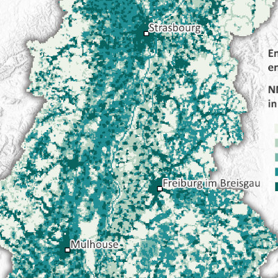
Emissions de COVNM par maille de 500m dans le Rhin supérieur (2021)
NMVOC emissions per 500m grid in the Upper Rhine (2021)
NMVOC-Emissionen 500m Rasterzelle am Oberrhein (2021)
Produite dans le cadre du projet Interreg Rhin Supérieur Atmo-Rhena PLUS, cette carte représente les émissions de composés organiques volatils non méthaniques (COVNM) sur le territoire du Rhin supérieur en 2021.
La limitation des émissions de polluants atmosphériques est le levier le plus important pour réduire les concentrations de polluants dans l'atmosphère. L’inventaire transfrontalier des émissions, à partir duquel a été réalisée cette carte, permet de déterminer les contributions des secteurs d’activité et des sources d’énergie aux émissions de différents polluants de l’air et ainsi d’identifier les actions pour réduire les concentrations des polluants dans l’atmosphère.
Les COVNM sont des polluants très variés dont les sources d'émissions sont multiples. L'utilisation industrielle et domestique de solvants et le transport routier et les autres transports (combustion de carburants et évaporation depuis les réservoirs, ou encore de lave-glace et dégivrants) sont des sources d'émissions importantes. La consommation de combustibles (fossiles ou naturels) émet également des COVNM mais plus faiblement que les activités citées précédemment.
Les composés organiques volatiles sont des précurseurs d’ozone et contribuent ainsi aux pics de pollution estivaux.
La carte statique sous format PDF est disponible à l'échelle de mailles de 500m. Les données sont accessibles en opendata uniquement à l'échelle des EPCI, Kreis et Cantons.
Produced as part of the Interreg Upper Rhine Atmo-Rhena PLUS project, this map shows emissions of non-methane volatile organic compounds (NMVOCs) in the Upper Rhine region in 2021.
Limiting air pollutant emissions is the most important lever for reducing pollutant concentrations in the atmosphere. The cross-border emissions inventory, on which this map is based, makes it possible to determine the contributions of different sectors of activity and energy sources to emissions of various air pollutants and thus to identify actions to reduce pollutant concentrations in the atmosphere.
NMVOCs are a wide variety of pollutants with multiple emission sources. Industrial and domestic use of solvents, road transport and other forms of transport (fuel combustion and evaporation from tanks, or windscreen washer fluid and de-icers) are significant sources of emissions. The consumption of fuels (fossil or natural) also emits NMVOCs, but to a lesser extent than the activities mentioned above.
Volatile organic compounds are ozone precursors and thus contribute to summer pollution peaks.
The static map in PDF format is available at a scale of 500m. The data is accessible as open data only at the scale of EPCI, Kreis and Cantons.
Diese Karte wurde im Rahmen des Interreg-Projekts Oberrhein Atmo-Rhena PLUS erstellt und stellt die Emissionen der Flüchtigen organischen Verbindungen ohne Methan (NMVOC) am Oberrheingebiet dar.
Die Begrenzung der Luftschadstoffemissionen ist der wichtigste Hebel, um die Schadstoffkonzentrationen in der Atmosphäre zu verringern. Mit der grenzüberschreitenden Erhebung der Luftschadstoffemissionen lassen sich die Beiträge der verschiedenen Quellengruppen und Energieerzeugungsarten zu den verschiedenen Luftschadstoffemissionen im Oberrheingebiet ermitteln und somit Maßnahmen zur Verringerung der Schadstoffkonzentrationen in der Atmosphäre festlegen.
Flüchtige organische Verbindungen ohne Methan (NMVOC) bestehen aus einer Vielzahl von Einzelstoffen und stammen aus verschiedenen Emissionsquellen. Die industrielle und häusliche Verwendung von Lösungsmitteln und der Straßen- und Flugverkehr (Verbrennung, Verdunstung aus den Tanks, Verwendung von Scheibenwischflüssigkeit und Enteisungsmitteln) sowie der Gesundheitsbereich (Desinfektionsmittel) sind wichtige Emissionsquellen. NMVOC-Emissionen fallen auch in geringen Mengen beim Verbrauch von Brennstoffen (fossiler oder natürlicher Art) an.
NMVOC sind Ozonvorläufer und tragen somit zu den sommerlichen Belastungsspitzen bei.
Die statische Karte im PDF-Format ist im Maßstab 500 m verfügbar. Die Daten sind als Open Data nur im Maßstab der EPCI, Kreise und Kantone zugänglich.
Simple
-
Date (Creation)Datumsangaben (Erstellung)Date (Création)
- 2025-08-07
-
Date (Publication)Datumsangaben (Publikation)Date (Publication)
- 2025-11-07
-
Citation identifierIdentifikatorIdentificateur
- AtmoRhenaPlus_covnm_maille_500m
-
StatusBearbeitungsstatusEtat
-
CompletedAbgeschlossenFinalisé
- Point of contact
-
Organisation name Individual name Electronic mail address Role GeoRhena
GeoRhena
GeoRhena
Point of contactAnsprechpartnerPoint de contactATMO Grand Est
ATMO Grand Est
ATMO Grand Est
CustodianVerwalterGestionnaireLandesanstalt für Umwelt Baden-Württemberg (LUBW)
CustodianVerwalterGestionnaireLufthygieneamt beider Basel
CustodianVerwalterGestionnaireLandesamt für Umwelt Rheinland-Pfalz
CustodianVerwalterGestionnaireOffice de l'environnement - République et Canton du Jura
CustodianVerwalterGestionnaireDepartement Bau, Verkehr und Umwelt - Kanton Aargau
CustodianVerwalterGestionnaire
-
Maintenance and update frequencyÜberarbeitungsintervallFréquence de mise à jour
-
Not plannedNicht geplantNon planifiée
-
ThemeThemaThème
-
-
Rhin Supérieur
Upper Rhine
Oberrhein
-
Transfrontalier
Crossborder
Grenzüberschreitend
-
-
Limitation d'utilisationUse limitationAnwendungseinschränkungen
-
Licence ODbL V1.0
CC-BY Licence ©OpenStreetMap contributors ©GeoRhena
CC-BY Lizenz ©OpenStreetMap contributors ©GeoRhena
-
Access constraintsZugriffseinschränkungenContraintes d'accès
-
Other restrictionsBenutzerdefinierte EinschränkungenAutres restrictions
-
Use constraintsNutzungseinschränkungenContraintes d'utilisation
-
Other restrictionsBenutzerdefinierte EinschränkungenAutres restrictions
-
Autres contraintesOther constraintsAndere Einschränkungen
-
Pas d'autre limitation
No other limitation
Keine andere Einschränkung
-
Spatial representation typeRäumliche DarstellungsartType de représentation spatiale
-
VectorVektorVecteur
-
DenominatorMaßstabszahlDénominateur de l'échelle
- 50000
-
LanguageSpracheLangue de la ressource
- Français
-
LanguageSpracheLangue de la ressource
- Deutsch
-
LanguageSpracheLangue de la ressource
- English
-
Character setZeichensatzEncodage des caractères
-
UTF8Utf8Utf8
-
Topic categoryISO-ThematikCatégorie ISO
-
-
EnvironmentUmweltEnvironnement
-
HealthGesundheitswesenSanté
-
- Begin date
- 2020-01-01
- End date
- 2021-12-31
))
Digital transfer options
Digitale Transferoptionen
Options de transfert numérique
- OnLine resource
-
Protocol Linkage Name OGC:WMS
https://portailsig.atmo-grandest.eu/server/services/Flux_Atmorhenaplus/atmo_rhena_plus_emi_covnm_nmvoc/MapServer/WMSServer 0
OGC:WFS
https://portailsig.atmo-grandest.eu/server/services/Flux_Atmorhenaplus/atmo_rhena_plus_emi_covnm_nmvoc/MapServer/WFSServer Emissions de COVNM
NMVOC Emmissions
NMVOC-Emissionen
WWW:LINK-1.0-http--link
https://atmo-rhena.eu/ Portail Qualité de l’air du le Rhin supérieur
Upper Rhine Air Quality Portal
Luftqualitätsportal Oberrhein
WWW:DOWNLOAD-1.0-http--download
https://www.georhena.eu/sites/default/files/Cartes/Emi_covnm_cadastre_500m_A6.pdf Emissions de COVNM par maille de 500m
NMVOC emissions per 500m mesh
NMVOC-Emissionen 500m Rasterzelle
OnLine resource
Online
Ressource en ligne
Digital transfer options
Digitale Transferoptionen
Options de transfert numérique
- OnLine resource
-
Protocol Linkage Name WWW:LINK-1.0-http--related
https://plateforme.atmo-grandest.eu/projets/atmo-rhena-plus.php Tableau de bord Air-Climat-Energie du Rhin supérieur
Upper Rhine Air-Climate-Energy Dashboard
Dashboard Luft-Klima-Energie am Oberrhein
-
Hierarchy levelBezugsebeneNiveau
-
staticMapstaticMapstaticMap
-
Généralités sur la provenanceStatementErläuterung
-
Collecte des émissions estimées pour la région Grand Est (ATMO Grand Est), le Bade Wurtemberg (Landesanstalt für Umwelt Bade-Wurtemberg – LUBW),les Cantons de Bâle Ville et Bâle Campagne (Lufthygienamt Beider Basel – LHA), la Rhénanie Palatinat (Landesamt für Umwelt Rheinland-Pfalz – LfU), le Canton du Jura (Office de l'environnement - ENV Jura) et le Canton Argovie (Departement Bau, Verkehr und Umwelt – BVU Aargau). Les données des cantons du Jura, d'Argovie et de Soleure ont été cadastrées à partir de données cantonales ou communales.
Collection of estimated emissions for the Grand Est region (ATMO Grand Est), Baden-Württemberg (Landesanstalt für Umwelt Baden-Württemberg – LUBW), the cantons of Basel-Stadt and Basel-Landschaft (Lufthygienamt Beider Basel – LHA), Rhineland-Palatinate (Landesamt für Umwelt Rheinland-Pfalz – LfU), the Canton of Jura (Office de l'environnement - ENV Jura) and the Canton of Aargau (Departement Bau, Verkehr und Umwelt – BVU Aargau). Data for the cantons of Jura, Aargau and Solothurn were recorded based on cantonal or municipal data.
Messungen der Netzwerke zur Überwachung der Luftqualität in der Region Grand Est (ATMO Grand Est), in Baden-Württemberg (Landesanstalt für Umwelt Baden-Württemberg - LUBW), in den Kantonen Basel-Stadt und Basel-Landschaft (Lufthygienamt Beider Basel - LHA), in Rheinland-Pfalz (Landesamt für Umwelt Rheinland-Pfalz – LfU), den Kanton Jura (Office de l'environnement - ENV Jura) und den Kanton Aargau (Departement Bau, Verkehr und Umwelt – BVU Aargau). Die Daten der Kantone Jura, Aargau und Solothurn wurden anhand von kantonalen oder kommunalen Daten katasterisiert.
Metadata
-
File identifierMetadatensatzidentifikatorIdentifiant de la fiche
- bb8e17f9-491f-4677-914a-ddac0e9dc508 XML
-
Metadata languageSpracheLangue
- Français
-
Character setZeichensatzJeu de caractères
-
UTF8Utf8Utf8
-
Hierarchy levelHierarchieebeneType de ressource
-
staticMapstaticMapstaticMap
-
Date stampDatumDate des métadonnées
- 2025-11-07T10:04:29.824824Z
- Metadata standard name
-
ISO 19115:2003/19139
- Metadata standard version
-
1.0
- Metadata author
-
Organisation name Individual name Electronic mail address Role GeoRhena: Système d'Information Géographique du Rhin Supérieur
GeoRhena: Geographical Information System of the Upper Rhine
GeoRhena: Geographische Informationssystem des Oberrheins
Point of contactAnsprechpartnerPoint de contact
- Other language
-
Language Character encoding EnglishEnglischAnglaisUTF8Utf8Utf8GermanDeutschAllemandUTF8Utf8Utf8FrenchFranzösischFrançaisUTF8Utf8Utf8
)))
