 Catalogue DataGrandEst
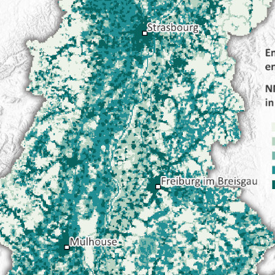
NMVOC emissions per 500m grid in the Upper Rhine (2021)
Produced as part of the Interreg Upper Rhine Atmo-Rhena PLUS project, this map shows emissions of non-methane volatile organic compounds (NMVOCs) in the Upper Rhine region in 2021.
Limiting air pollutant emissions is the most important lever for reducing pollutant concentrations in the atmosphere. The cross-border emissions inventory, on which this map is based, makes it possible to determine the contributions of different sectors of activity and energy sources to emissions of various air pollutants and thus to identify actions to reduce pollutant concentrations in the atmosphere.
NMVOCs are a wide variety of pollutants with multiple emission sources. Industrial and domestic use of solvents, road transport and other forms of transport (fuel combustion and evaporation from tanks, or windscreen washer fluid and de-icers) are significant sources of emissions. The consumption of fuels (fossil or natural) also emits NMVOCs, but to a lesser extent than the activities mentioned above.
Volatile organic compounds are ozone precursors and thus contribute to summer pollution peaks.
The static map in PDF format is available at a scale of 500m. The data is accessible as open data only at the scale of EPCI, Kreis and Cantons.
Simple
- Date (Creation)
- 2025-08-07
- Date (Publication)
- 2025-11-07
- Citation identifier
- AtmoRhenaPlus_covnm_maille_500m
- Status
- Completed
- Point of contact
-
Organisation name Individual name Electronic mail address Role GeoRhena
Point of contact ATMO Grand Est
Custodian Landesanstalt für Umwelt Baden-Württemberg (LUBW)
Custodian Lufthygieneamt beider Basel
Custodian Landesamt für Umwelt Rheinland-Pfalz
Custodian Office de l'environnement - République et Canton du Jura
Custodian Departement Bau, Verkehr und Umwelt - Kanton Aargau
Custodian
- Maintenance and update frequency
- Not planned
- Theme
-
-
Upper Rhine
-
Crossborder
-
- Use limitation
-
CC-BY Licence ©OpenStreetMap contributors ©GeoRhena
- Access constraints
- Other restrictions
- Use constraints
- Other restrictions
- Other constraints
-
No other limitation
- Spatial representation type
- Vector
- Denominator
- 50000
- Language
- Français
- Language
- Deutsch
- Language
- English
- Character set
- UTF8
- Topic category
-
- Environment
- Health
- Begin date
- 2020-01-01
- End date
- 2021-12-31
))
Digital transfer options
- OnLine resource
-
Protocol Linkage Name OGC:WMS
https://portailsig.atmo-grandest.eu/server/services/Flux_Atmorhenaplus/atmo_rhena_plus_emi_covnm_nmvoc/MapServer/WMSServer 0
OGC:WFS
https://portailsig.atmo-grandest.eu/server/services/Flux_Atmorhenaplus/atmo_rhena_plus_emi_covnm_nmvoc/MapServer/WFSServer NMVOC Emmissions
WWW:LINK-1.0-http--link
https://atmo-rhena.eu/ Upper Rhine Air Quality Portal
WWW:DOWNLOAD-1.0-http--download
https://www.georhena.eu/sites/default/files/Cartes/Emi_covnm_cadastre_500m_A6.pdf NMVOC emissions per 500m mesh
OnLine resource
Digital transfer options
- OnLine resource
-
Protocol Linkage Name WWW:LINK-1.0-http--related
https://plateforme.atmo-grandest.eu/projets/atmo-rhena-plus.php Upper Rhine Air-Climate-Energy Dashboard
- Hierarchy level
- staticMap
- Statement
-
Collection of estimated emissions for the Grand Est region (ATMO Grand Est), Baden-Württemberg (Landesanstalt für Umwelt Baden-Württemberg – LUBW), the cantons of Basel-Stadt and Basel-Landschaft (Lufthygienamt Beider Basel – LHA), Rhineland-Palatinate (Landesamt für Umwelt Rheinland-Pfalz – LfU), the Canton of Jura (Office de l'environnement - ENV Jura) and the Canton of Aargau (Departement Bau, Verkehr und Umwelt – BVU Aargau). Data for the cantons of Jura, Aargau and Solothurn were recorded based on cantonal or municipal data.
Metadata
- File identifier
- bb8e17f9-491f-4677-914a-ddac0e9dc508 XML
- Metadata language
- Français
- Character set
- UTF8
- Hierarchy level
- staticMap
- Date stamp
- 2025-11-07T10:04:29.824824Z
- Metadata standard name
-
ISO 19115:2003/19139
- Metadata standard version
-
1.0
- Metadata author
-
Organisation name Individual name Electronic mail address Role GeoRhena: Geographical Information System of the Upper Rhine
Point of contact
- Other language
-
Language Character encoding English UTF8 German UTF8 French UTF8
)))
