 Catalogue DataGrandEst
Corine Land Cover : Occupation du sol dans la région du Rhin supérieur
Corine Land Cover : Landnutzung im Oberrheingebiet
Corine Land Cover - Land cover in the upper rhine region
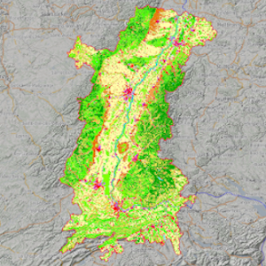
Occupation du sol du Rhin Supérieur - 2018
Landnutzung im Oberrheingebiet - 2018
Upper Rhine land cover - 2018
Simple
-
Autres appellations ou acronymesAlternativtitelAlternate title
-
Parcs naturels et réserves de biosphère - 2021
Naturparks und Biosphärenreservate - 2021
CLC 2018
-
Datumsangaben (Erstellung)Date (Creation)Date (Création)
- 2019-04-26
-
Datumsangaben (Publikation)Date (Publication)Date (Publication)
- 2021-11-03
-
Datumsangaben (Überarbeitung)Date (Revision)Date (Révision)
- 2021-11-03
-
IdentifikatorCitation identifierIdentificateur
- CLC_2018_CRS_ORK
-
BearbeitungsstatusStatusEtat
-
AbgeschlossenCompletedFinalisé
- Point of contact
-
Organisation name Individual name Electronic mail address Role GeoRhena
GeoRhena
GeoRhena
GeoRhena
AnsprechpartnerPoint of contactPoint de contact
-
ÜberarbeitungsintervallMaintenance and update frequencyFréquence de mise à jour
-
Nicht geplantNot plannedNon planifiée
- Keywords
-
-
Données ouvertes
Open-Data
Open-Data
-
-
OrtPlaceLocalisation
-
-
Rhin Supérieur
Oberrhein
Upper Rhine
-
-
GEMET - Concepts, version 2.4
GEMET - Concepts, version 2.4
-
-
occupation du sol
Flächennutzung
land occupation
-
-
Limitation d'utilisationAnwendungseinschränkungenUse limitation
-
Accès libre et gratuit à cette donnée © European Union, Copernicus Land Monitoring Service 2018, European Environment Agency (EEA)
Freier Zugang zu diesen Daten. © European Union, Copernicus Land Monitoring Service 2018, European Environment Agency (EEA)
Free, full and open access to this data - © European Union, Copernicus Land Monitoring Service 2018, European Environment Agency (EEA)
-
ZugriffseinschränkungenAccess constraintsContraintes d'accès
-
Benutzerdefinierte EinschränkungenOther restrictionsAutres restrictions
-
NutzungseinschränkungenUse constraintsContraintes d'utilisation
-
Benutzerdefinierte EinschränkungenOther restrictionsAutres restrictions
-
Autres contraintesAndere EinschränkungenOther constraints
-
Pas d'autre limitation
Keine andere Einschränkung
No other limitation
-
Räumliche DarstellungsartSpatial representation typeType de représentation spatiale
-
VektorVectorVecteur
-
MaßstabszahlDenominatorDénominateur de l'échelle
- 100000
-
SpracheLanguageLangue de la ressource
- English
-
ZeichensatzCharacter setEncodage des caractères
-
Utf8UTF8Utf8
-
ISO-ThematikTopic categoryCatégorie ISO
-
-
OberflächenbeschreibungImagery base maps earth coverCarte de référence de la couverture terrestre
-
- Begin date
- 2018-01-01
- End date
- 2018-12-31
))
- Distribution format
-
Name Version Géodonnée au format SHP
GeoDatei im SHP Format
SHP GeoData
-
Digitale Transferoptionen
Digital transfer options
Options de transfert numérique
- OnLine resource
-
Protocol Linkage Name OGC:WMS
https://geoportal.georhena.eu/geoserver/basemaps/ows occupation_sol_2018
OGC:WFS
https://geoportal.georhena.eu/geoserver/basemaps/ows basemaps:occupation_sol_2018
WWW:DOWNLOAD-1.0-ftp--download
https://geoportal.georhena.eu/geoserver/basemaps/ows?request=GetFeature&service=WFS&typeName=occupation_sol_2018&version=1.0.0&outputFormat=SHAPE-ZIP Téléchargement du Shapefile
Téléchargement du Shapefile
Téléchargement du Shapefile
-
BezugsebeneHierarchy levelNiveau
-
DatenbestandDatasetJeu de données
-
Généralités sur la provenanceErläuterungStatement
-
OSM + GeoRhena
OSM + GeoRhena
OSM + GeoRhena
Metadata
-
MetadatensatzidentifikatorFile identifierIdentifiant de la fiche
- c0ccbf45-2620-4bde-93f8-869558e51d7e XML
-
SpracheMetadata languageLangue
- Français
-
ZeichensatzCharacter setJeu de caractères
-
Utf8UTF8Utf8
-
HierarchieebeneHierarchy levelType de ressource
-
DatenbestandDatasetJeu de données
-
DatumDate stampDate des métadonnées
- 2022-10-03T15:42:24.258107Z
- Metadata standard name
-
ISO 19115:2003/19139
- Metadata standard version
-
1.0
- Metadata author
-
Organisation name Individual name Electronic mail address Role GeoRhena: Système d'Information Géographique du Rhin Supérieur
GeoRhena: Geographische Informationssystem des Oberrheins
GeoRhena: Geographical Information System of the Upper Rhine
AnsprechpartnerPoint of contactPoint de contact
- Other language
-
Language Character encoding DeutschGermanAllemandUtf8UTF8Utf8EnglischEnglishAnglaisUtf8UTF8Utf8FranzösischFrenchFrançaisUtf8UTF8Utf8
)))
