Catalogue DataGrandEst
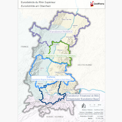
Upper Rhine Eurodistricts
This map shows the various Eurodistricts, or cooperation bodies, in the Upper Rhine.
Simple
- Date (Creation)
- 2019-01-01
- Date (Publication)
- 2024-02-01
- Date (Revision)
- 2025-12-09
- Citation identifier
- Eurodistricts_2019
- Status
- Completed
- Point of contact
-
Organisation name Individual name Electronic mail address Role GeoRhena
GeoRhena
Processor
- Maintenance and update frequency
- Not planned
- Place
-
-
Upper Rhine
-
Eurodistrict
-
- Theme
-
-
Crossborder
-
- Use limitation
-
Licence CC BY
- Access constraints
- Other restrictions
- Use constraints
- Other restrictions
- Other constraints
-
No other limitation
- Denominator
- 100000
- Language
- Français
- Language
- Deutsch
- Character set
- UTF8
- Topic category
-
- Economy
- Distribution format
-
Name Version PDF Map
-
Digital transfer options
- OnLine resource
-
Protocol Linkage Name WWW:DOWNLOAD-1.0-http--download
https://www.georhena.eu/sites/default/files/Cartes/10_2025_366.pdf Upper Rhine Eurodistricts
Metadata
- File identifier
- c107db4f-9634-4e87-9e65-f259c51914b8 XML
- Metadata language
- Français
- Character set
- UTF8
- Hierarchy level
- staticMap
- Hierarchy level name
-
Carte statique
- Date stamp
- 2025-12-09T11:06:27.86482Z
- Metadata standard name
-
ISO 19115:2003/19139
- Metadata standard version
-
1.0
- Metadata author
-
Organisation name Individual name Electronic mail address Role GeoRhena: Geographical Information System of the Upper Rhine
Author
- Other language
-
Language Character encoding German UTF8 English UTF8 French UTF8