 Catalogue DataGrandEst
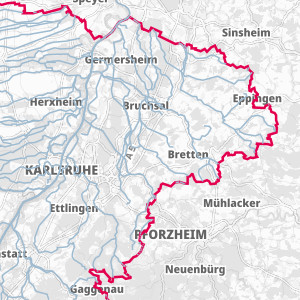
Watercourses of the Water Framework Directive on the Upper Rhine
FR: Upper Rhine surface water bodies defined by the Water Framework Directive 2016, with a catchment area > 10km²
DE: Upper Rhine surface water bodies defined by the Water Framework Directive 2016, with a catchment area > 10km²
CH : Water bodies of the Upper Rhine with a division equivalent to the criteria of the Water Framework Directive, as the Directive does not apply in Switzerland (water bodies with a catchment area > 10 km² from the SwissTLMRegio Hydrography)
Simple
- Date (Creation)
- 2021-05-11
- Date (Publication)
- 2021-05-11
- Citation identifier
- cours_eau_wassernetz
- Status
- Completed
- Point of contact
-
Organisation name Individual name Electronic mail address Role GeoRhena
GeoRhena
GeoRhena
Point of contact Association pour la Protection de la Nappe Phréatique de la Plaine d'Alsace (APRONA)
Processor Water Resources Expert Committee
Originator Landesanstalt für Umwelt Baden-Württemberg (LUBW)
Custodian Regierungspräsidium Freiburg -Gewässer und Boden (RPF-GB)
Custodian Regierungspräsidium Freiburg - Landesamt für Geologie, Rohstoffe und Bergbau (RPF-LGRB)
Custodian Landesamt für Umwelt -- Rheinland-Pfalz (LfU –RP)
Custodian Struktur- und Genehmigungsdirektion Süd Rheinland-Pfalz (SGD-Süd-RP)
Custodian Amt für Umweltschutz und Energie, Basel-Stadt (AUE-BS)
Custodian Région Grand-Est (RGE)
Custodian Direction Régionale de l’Environnement, Aménagement et du Logement (DREAL)
Custodian BRGM Service Géologique Régional d’Alsace (BRGM)
Custodian Association pour la Protection de la Nappe Phréatique de la Plaine d'Alsace (APRONA)
Custodian Landesamt für Geologie und Bergbau Rheinland-Pfalz (LGB-RP)
Custodian Amt für Umweltschutz und Energie, Basel-Landschaft (AUE-BL)
Custodian
- Maintenance and update frequency
- Not planned
- Keywords
-
-
Open-Data
-
- Place
-
-
Upper Rhine
-
-
GEMET - INSPIRE themes, version 1.0
-
-
Hydrography
-
-
GEMET - Concepts, version 2.4
-
-
hydrographic network
-
surface water
-
- Use limitation
-
© + APRONA 2021 + Add GeoRhena logo in case of reuse
- Access constraints
- Other restrictions
- Use constraints
- Other restrictions
- Other constraints
-
No other limitation
- Spatial representation type
- Vector
- Denominator
- 24997
- Language
- Français
- Character set
- UTF8
- Topic category
-
- Inland waters
- Begin date
- 2016-01-01
- End date
- 2016-12-31
))
- Distribution format
-
Name Version SHP GeoData
-
Digital transfer options
- OnLine resource
-
Protocol Linkage Name OGC:WMS
https://geoportal.georhena.eu/geoserver/water/ows cours_eau_dce
OGC:WFS
https://geoportal.georhena.eu/geoserver/water/ows water:cours_eau_dce
WWW:DOWNLOAD-1.0-ftp--download
https://geoportal.georhena.eu/geoserver/water/ows?request=GetFeature&service=WFS&typeName=cours_eau_dce&version=1.0.0&outputFormat=SHAPE-ZIP Téléchargement du Shapefile
- Hierarchy level
- Dataset
- Statement
-
GeoRhena + OSM contributors - 2016
Metadata
- File identifier
- c13d54f0-4f1a-4e72-85ac-fbf29fdcdeb8 XML
- Metadata language
- Français
- Character set
- UTF8
- Date stamp
- 2022-11-16T14:11:56.401572Z
- Metadata standard name
-
ISO 19115:2003/19139
- Metadata standard version
-
1.0
- Metadata author
-
Organisation name Individual name Electronic mail address Role GeoRhena: Geographical Information System of the Upper Rhine
Distributor
- Other language
-
Language Character encoding German UTF8 English UTF8 French UTF8
Overviews
Spatial extent
)))
Provided by
