 Catalogue DataGrandEst
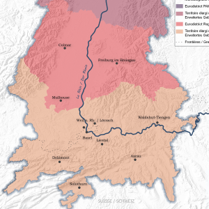
Eurodistricts du Rhin Supérieur et leurs territoires d'action élargis
Eurodistrikte am Oberrhein und ihre erweiterten Aktionsgebiete
Upper Rhine Eurodistricts and their extended territories of action
Cette carte représente les territoires élargis des Eurodistricts du Rhin supérieur.
Diese Karte stellt die erweiterten Gebiete der Eurodistrikte am Oberrhein dar.
This map shows the enlarged territories of the Upper Rhine Eurodistricts.
Simple
-
Datumsangaben (Erstellung)Date (Creation)Date (Création)
- 2022-05-04
-
Datumsangaben (Publikation)Date (Publication)Date (Publication)
- 2022-06-16
-
IdentifikatorCitation identifierIdentificateur
- 10_2022_286
-
BearbeitungsstatusStatusEtat
-
AbgeschlossenCompletedFinalisé
- Point of contact
-
Organisation name Individual name Electronic mail address Role GeoRhena
GeoRhena
GeoRhena
GeoRhena
BearbeiterProcessorExécutantCollectivité Européenne d'Alsace
Collectivité Européenne d'Alsace
Collectivité Européenne d'Alsace
UrheberOriginatorA l’origine de
-
ÜberarbeitungsintervallMaintenance and update frequencyFréquence de mise à jour
-
Nicht geplantNot plannedNon planifiée
- Keywords
-
-
Carte
Karte
Map
-
-
OrtPlaceLocalisation
-
-
Rhin Supérieur
Oberrhein
Upper Rhine
-
Eurodistrict
Eurodistrikt
Eurodistrict
-
-
GEMET - Concepts, version 2.4
-
-
limite administrative
Verwaltungsgrenze
administrative boundary
-
coopération
Zusammenarbeit
co-operation
-
-
Limitation d'utilisationAnwendungseinschränkungenUse limitation
-
Licence CC BY
Licence CC BY
Licence CC BY
-
ZugriffseinschränkungenAccess constraintsContraintes d'accès
-
Benutzerdefinierte EinschränkungenOther restrictionsAutres restrictions
-
NutzungseinschränkungenUse constraintsContraintes d'utilisation
-
Benutzerdefinierte EinschränkungenOther restrictionsAutres restrictions
-
Autres contraintesAndere EinschränkungenOther constraints
-
Pas d'autre limitation
Keine andere Einschränkung
No other limitation
-
MaßstabszahlDenominatorDénominateur de l'échelle
- 1000
-
SpracheLanguageLangue de la ressource
- Français
-
ZeichensatzCharacter setEncodage des caractères
-
Utf8UTF8Utf8
-
ISO-ThematikTopic categoryCatégorie ISO
-
-
GrenzenBoundariesLimites politiques et administratives
-
- Begin date
- 2022-01-01
- End date
- 2022-12-31
))
- Distribution format
-
Name Version Carte au format PDF
Karte in PDF
PDF Map
-
Digitale Transferoptionen
Digital transfer options
Options de transfert numérique
- OnLine resource
-
Protocol Linkage Name WWW:DOWNLOAD-1.0-http--download
https://www.georhena.eu/sites/default/files/Cartes/10_2022_286.pdf Téléchargement du Pdf
Pdf herunterladen
Pdf Download
Metadata
-
MetadatensatzidentifikatorFile identifierIdentifiant de la fiche
- c18d7f97-92ec-4e56-b8fa-7919f802b617 XML
-
SpracheMetadata languageLangue
- Français
-
ZeichensatzCharacter setJeu de caractères
-
Utf8UTF8Utf8
-
HierarchieebeneHierarchy levelType de ressource
-
staticMapstaticMapstaticMap
- Hierarchy level name
-
Dataset
-
DatumDate stampDate des métadonnées
- 2025-06-13T11:44:19.0452Z
- Metadata standard name
-
ISO 19115:2003/19139
- Metadata standard version
-
1.0
- Metadata author
-
Organisation name Individual name Electronic mail address Role GeoRhena: Système d'Information Géographique du Rhin Supérieur
GeoRhena: Geographische Informationssystem des Oberrheins
GeoRhena: Geographical Information System of the Upper Rhine
AutorAuthorAuteur
- Other language
-
Language Character encoding DeutschGermanAllemandUtf8UTF8Utf8EnglischEnglishAnglaisUtf8UTF8Utf8FranzösischFrenchFrançaisUtf8UTF8Utf8
)))
