 Catalogue DataGrandEst
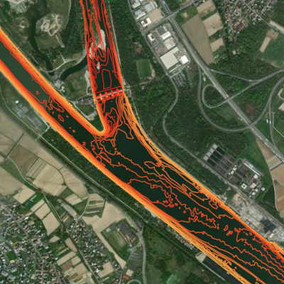
Isolignes du fleuve Rhin sur une zone d'intérêt
Isolinien des Flussbettes des Rheins für ein Untersuchungsgebiet
Isolines for the river Rhine for an area of interest
Ces données correspondent aux courbes de niveau du fond du Rhin, c'est à dire des lignes reliant des points d'altitude égale. Celles-ci ont été produites sur base de relevés bathymétriques et aériens pour une zone d'intérêt spécifique (AOI) délimitée par les bornes kilométriques 170 et 180. Ne pas utiliser pour la navigation !
Diese Daten repräsentieren mit Hilfe von Isolinien (Linien gleicher Höhe) das Flussbett des Rheins. Sie sind aus bathymetrischen Aufnahmen und Befliegungen generiert worden und in verschiedene Untersuchungsgebiete (AOI) aufgeteilt; hier Flusskilometer 170-180. Nicht zur Navigation geeignet !
This data represents the bed of the river Rhine by the use of isolines. Based on bathymetric and aerial survey data, only a specific area of interest (AOI 170-180) is represented. Do not use for navigation !
Simple
-
Datumsangaben (Erstellung)Date (Creation)Date (Création)
- 2023-07-10
-
Datumsangaben (Publikation)Date (Publication)Date (Publication)
- 2023-08-24
-
IdentifikatorCitation identifierIdentificateur
- aoi_rhin_isolignes
-
BearbeitungsstatusStatusEtat
-
AbgeschlossenCompletedFinalisé
- Point of contact
-
Organisation name Individual name Electronic mail address Role GeoRhena
GeoRhena
GeoRhena
GeoRhena
GeoRhena
GeoRhena
AnsprechpartnerPoint of contactPoint de contactBundesanstalt für Gewässerkunde
Bundesanstalt für Gewässerkunde
Bundesanstalt für Gewässerkundeg
BfG
BfG
BfG
VerwalterCustodianGestionnaireWasserstraßen- und Schifffahrtsverwaltung des Bundes
Wasserstraßen- und Schifffahrtsverwaltung des Bundes
Wasserstraßen- und Schifffahrtsverwaltung des Bundes
WSV
WSV
WSV
Eigentümer / DatenherrOwnerPropriétaire
-
ÜberarbeitungsintervallMaintenance and update frequencyFréquence de mise à jour
-
Nicht geplantNot plannedNon planifiée
- Keywords
-
-
Rhin Supérieur
Oberrhein
Upper Rhine
-
rivière
Fluss
River
-
Bathymétrie
Bathymetrie
Bathymetry
-
fond
Gewässersohle
channel
-
relief
Flussrelief
-
isolignes
Isolinien
isolines
-
-
Limitation d'utilisationAnwendungseinschränkungenUse limitation
-
Licence CC BY
CC BY-Lizenz
CC BY Licence
-
ZugriffseinschränkungenAccess constraintsContraintes d'accès
-
Benutzerdefinierte EinschränkungenOther restrictionsAutres restrictions
-
NutzungseinschränkungenUse constraintsContraintes d'utilisation
-
Benutzerdefinierte EinschränkungenOther restrictionsAutres restrictions
-
Autres contraintesAndere EinschränkungenOther constraints
-
Pas d'autre limitation; GeoNutzV §2 et §3 , GeoZG
Keine andere Einschränkung; GeoNutzV §2 und §3 , GeoZG
No other limitation ; GeoNutzV §2 and §3 , GeoZG
-
Räumliche DarstellungsartSpatial representation typeType de représentation spatiale
-
Raster, GitterGridRaster
-
MaßstabszahlDenominatorDénominateur de l'échelle
- 100000
-
SpracheLanguageLangue de la ressource
- Français
-
ZeichensatzCharacter setEncodage des caractères
-
Utf8UTF8Utf8
-
ISO-ThematikTopic categoryCatégorie ISO
-
-
BinnengewässerInland watersEaux intérieures, Hydrographie
-
- Begin date
- 2003-01-01
- End date
- 2010-12-31
))
- Distribution format
-
Name Version Géodonnée au format vecteur
Vektorformat
Geodata as vector data
-
Digitale Transferoptionen
Digital transfer options
Options de transfert numérique
- OnLine resource
-
Protocol Linkage Name OGC:WMS
https://geoportal.georhena.eu/geoserver/environment/ows AOI_rhin_isolignes
OGC:WFS https://geoportal.georhena.eu/geoserver/environment/ows environment:AOI_rhin_isolignes
WWW:DOWNLOAD-1.0-ftp--download https://geoportal.georhena.eu/geoserver/environment/ows?request=GetFeature&service=WFS&typeName=aoi_rhin_isolignes&version=1.0.0&outputFormat=SHAPE-ZIP Téléchargement du fichier sous format vectoriel
Downloadlink für die Vektordatei
Download vector data
-
BezugsebeneHierarchy levelNiveau
-
DatenbestandDatasetJeu de données
-
Généralités sur la provenanceErläuterungStatement
-
Les données d'origine ont été fournies par la BFG (gestionnaire) et sont la propriété de la WSV (propriétaire). Elles étaient sous forme de .xyz et concernaient une zone un peu plus large que celle du Rhin. GeoRhena a effectué les traitements suivants : assemblage, découpage, reprojection et création d'isolignes.
Attention! le système de référence altimétrique d'origine est maintenant obsolète. Il s'agit du DHHN92.
Avec nos remerciements pour la Wasserstraßen- und Schifffahrtsverwaltung et le Bundesanstalt für Gewässerkunde.
Die Originaldaten wurden vom BfG zur Verfügung gestellt. Eigentümerin ist die WSV. Der gesamtdatensatz liegt im .xyz-Format vor und hat eine etwas grössere Ausdehnung als der Rhein. GeoRhena hat folgende Prozesse durchgeführt: Zusammenfügen; Beschneiden, Reprojektion und Erstellung von Isolinien.
Hinweis: die Daten liegen in einem veralteten Höhensystem vor: DHHN92.
Mit bestem Dank an die Wasserstraßen- und Schifffahrtsverwaltung und das Bundesanstalt für Gewässerkunde.
The original data was supplied by the BFG (manager) and is the property of the WSV (owner). They were in .xyz format and covered an area slightly larger than that of the Rhine. GeoRhena carried out the following processing: assembly, cutting, reprojection and creation of isolines.
Please note: the original height reference system is now obsolete. It is DHHN92.
With thanks to the Wasserstraßen- und Schifffahrtsverwaltung and the Bundesanstalt für Gewässerkunde.
Metadata
-
MetadatensatzidentifikatorFile identifierIdentifiant de la fiche
- dea1901c-5d17-488c-b379-291018612427 XML
-
SpracheMetadata languageLangue
- Français
-
ZeichensatzCharacter setJeu de caractères
-
Utf8UTF8Utf8
-
HierarchieebeneHierarchy levelType de ressource
-
DatenbestandDatasetJeu de données
-
DatumDate stampDate des métadonnées
- 2025-08-20T12:53:08.229163Z
- Metadata standard name
-
ISO 19115:2003/19139
- Metadata standard version
-
1.0
- Metadata author
-
Organisation name Individual name Electronic mail address Role GeoRhena: Système d'Information Géographique du Rhin Supérieur
GeoRhena: Geographische Informationssystem des Oberrheins
GeoRhena: Geographical Information System of the Upper Rhine
AnsprechpartnerPoint of contactPoint de contact
- Other language
-
Language Character encoding DeutschGermanAllemandUtf8UTF8Utf8EnglischEnglishAnglaisUtf8UTF8Utf8FranzösischFrenchFrançaisUtf8UTF8Utf8
)))
