 Catalogue DataGrandEst
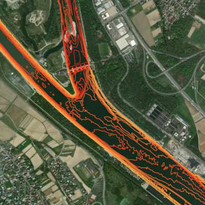
Isolines for the river Rhine for an area of interest
This data represents the bed of the river Rhine by the use of isolines. Based on bathymetric and aerial survey data, only a specific area of interest (AOI 170-180) is represented. Do not use for navigation !
Simple
- Date (Creation)
- 2023-07-10
- Date (Publication)
- 2023-08-24
- Citation identifier
- aoi_rhin_isolignes
- Status
- Completed
- Point of contact
-
Organisation name Individual name Electronic mail address Role GeoRhena
GeoRhena
Point of contact Bundesanstalt für Gewässerkundeg
BfG
Custodian Wasserstraßen- und Schifffahrtsverwaltung des Bundes
WSV
Owner
- Maintenance and update frequency
- Not planned
- Keywords
-
-
Upper Rhine
-
River
-
Bathymetry
-
channel
-
relief
-
isolines
-
- Use limitation
-
CC BY Licence
- Access constraints
- Other restrictions
- Use constraints
- Other restrictions
- Other constraints
-
No other limitation ; GeoNutzV §2 and §3 , GeoZG
- Spatial representation type
- Grid
- Denominator
- 100000
- Language
- Français
- Character set
- UTF8
- Topic category
-
- Inland waters
- Begin date
- 2003-01-01
- End date
- 2010-12-31
))
- Distribution format
-
Name Version Geodata as vector data
-
Digital transfer options
- OnLine resource
-
Protocol Linkage Name OGC:WMS
https://geoportal.georhena.eu/geoserver/environment/ows AOI_rhin_isolignes
OGC:WFS https://geoportal.georhena.eu/geoserver/environment/ows environment:AOI_rhin_isolignes
WWW:DOWNLOAD-1.0-ftp--download https://geoportal.georhena.eu/geoserver/environment/ows?request=GetFeature&service=WFS&typeName=aoi_rhin_isolignes&version=1.0.0&outputFormat=SHAPE-ZIP Download vector data
- Hierarchy level
- Dataset
- Statement
-
The original data was supplied by the BFG (manager) and is the property of the WSV (owner). They were in .xyz format and covered an area slightly larger than that of the Rhine. GeoRhena carried out the following processing: assembly, cutting, reprojection and creation of isolines.
Please note: the original height reference system is now obsolete. It is DHHN92.
With thanks to the Wasserstraßen- und Schifffahrtsverwaltung and the Bundesanstalt für Gewässerkunde.
Metadata
- File identifier
- dea1901c-5d17-488c-b379-291018612427 XML
- Metadata language
- Français
- Character set
- UTF8
- Hierarchy level
- Dataset
- Date stamp
- 2025-08-20T12:53:08.229163Z
- Metadata standard name
-
ISO 19115:2003/19139
- Metadata standard version
-
1.0
- Metadata author
-
Organisation name Individual name Electronic mail address Role GeoRhena: Geographical Information System of the Upper Rhine
Point of contact
- Other language
-
Language Character encoding German UTF8 English UTF8 French UTF8
)))
