 Catalogue DataGrandEst
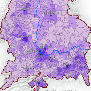
Ratio of urban area to municipal area in the Upper Rhine in 2009
This map shows the rate of urbanisation at the municipal level in the Upper Rhine area.
Simple
- Date (Creation)
- 2013-06-01
- Date (Publication)
- 2013-06-01
- Citation identifier
- 04_2013_183
- Status
- Completed
- Point of contact
-
Organisation name Individual name Electronic mail address Role GeoRhena
GeoRhena
Processor
- Maintenance and update frequency
- Not planned
- Keywords
-
-
Map
-
- Keywords
-
-
Upper Rhine
-
-
GEMET - Concepts, version 2.4
-
-
geography
-
land setup
-
urbanisation
-
city
-
- Use limitation
-
Licence CC BY
- Access constraints
- Other restrictions
- Use constraints
- Other restrictions
- Other constraints
-
No other limitation
- Denominator
- 100000
- Language
- Français
- Character set
- UTF8
- Topic category
-
- Imagery base maps earth cover
- Begin date
- 2009-01-01
- End date
- 2009-12-31
N
S
E
W
))
- Distribution format
-
Name Version PDF Map
-
Digital transfer options
- OnLine resource
-
Protocol Linkage Name WWW:DOWNLOAD-1.0-http--download
https://www.georhena.eu/sites/default/files/Cartes/04_2013_183.pdf Pdf Download
Metadata
- File identifier
- e9ca2aa0-1fcd-412b-9cc7-1f10127c023c XML
- Metadata language
- Français
- Character set
- UTF8
- Hierarchy level
- staticMap
- Hierarchy level name
-
Carte statique
- Date stamp
- 2022-09-26T08:23:42.081688Z
- Metadata standard name
-
ISO 19115:2003/19139
- Metadata standard version
-
1.0
- Metadata author
-
Organisation name Individual name Electronic mail address Role GeoRhena: Geographical Information System of the Upper Rhine
Author
- Other language
-
Language Character encoding German UTF8 English UTF8 French UTF8
)))
