Catalogue DataGrandEst
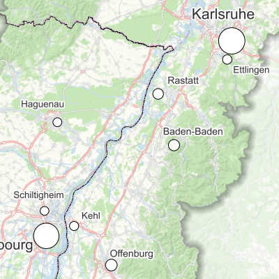
Upper Rhine cities with more than 30,000 inhabitants - 2020
Map showing the major towns with more than 30,000 inhabitants in the Upper Rhine region.
Simple
- Date (Creation)
- 2024-10-24
- Date (Publication)
- 2024-11-13
- Citation identifier
- 17_2024_345
- Status
- Completed
- Point of contact
-
Organisation name Individual name Electronic mail address Role GeoRhena
GeoRhena
Processor
- Maintenance and update frequency
- Not planned
- Keywords
-
-
Map
-
- Keywords
-
-
Upper Rhine
-
-
GEMET - Concepts, version 2.4
-
-
city
-
urban design
-
population (ecological)
-
- Use limitation
-
Licence CC BY - ©Upper Rhine Conference Statistics WG
- Access constraints
- Other restrictions
- Use constraints
- Other restrictions
- Other constraints
-
No other limitation
- Denominator
- 700000
- Language
- Français
- Character set
- UTF8
- Topic category
-
- Health
- Begin date
- 2024-01-01
- End date
- 2024-12-31
Digital transfer options
- OnLine resource
-
Protocol Linkage Name WWW:DOWNLOAD-1.0-http--download https://www.georhena.eu/sites/default/files/Cartes/17_2024_345.pdf Pdf Download
- Statement
-
The data comes from information produced by the Upper Rhine Statistical Working Group on the basis of population data for the three countries in 2020.
Metadata
- File identifier
- f7d86194-63ac-4700-8c34-697d5bd9dfe4 XML
- Metadata language
- Français
- Character set
- UTF8
- Hierarchy level
- staticMap
- Hierarchy level name
-
Carte statique
- Date stamp
- 2025-06-18T12:39:20.43012Z
- Metadata standard name
-
ISO 19115:2003/19139
- Metadata standard version
-
1.0
- Metadata author
-
Organisation name Individual name Electronic mail address Role GeoRhena: Geographical Information System of the Upper Rhine
Author
- Other language
-
Language Character encoding German UTF8 English UTF8 French UTF8