 Catalogue DataGrandEst
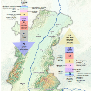
Flux amont et aval selon le type de marchandises sur le Rhin Supérieur - 2021
Güterstrom zu Berg und zu Tal nach Güterart am Oberrhein - 2021
Upstream and downstream flows by type of freight on the Upper Rhine - 2021
Cette carte représente les flux de marchandises transitant sur le Rhin Supérieur en fonction de leur type. Les données représentées datent de 2021 et concernent l'ensemble du Rhin Supérieur. Ce document a été réalisé dans le cadre d'une collaboration avec la Commission Centrale pour la Navigation du Rhin (CCNR).
Diese Karte stellt die Güterströme, die den Oberrhein durchqueren, nach ihrer Art dar. Die dargestellten Daten stammen aus dem Jahr 2021 und beziehen sich auf den gesamten Oberrhein. Dieses Dokument wurde im Rahmen einer Zusammenarbeit mit der Zentralkommission für die Rheinschifffahrt (ZKR) erstellt.
This map shows the freight flows on the Upper Rhine according to type. The data shown are from 2021 and relate to the entire Upper Rhine. This document was produced in collaboration with the Central Commission for Navigation on the Rhine (CCNR).
Simple
-
Datumsangaben (Erstellung)Date (Creation)Date (Création)
- 2022-06-08
-
Datumsangaben (Publikation)Date (Publication)Date (Publication)
- 2022-06-09
-
IdentifikatorCitation identifierIdentificateur
- 06_2022_287
-
BearbeitungsstatusStatusEtat
-
AbgeschlossenCompletedFinalisé
- Point of contact
-
Organisation name Individual name Electronic mail address Role GeoRhena
GeoRhena
GeoRhena
GeoRhena
BearbeiterProcessorExécutantCommission Centrale pour la Navigation du Rhin
Zentralkommission für die Rheinschifffahrt
Central Commission for Navigation on the Rhine
ccnr@ccr-zkr.org
ccnr@ccr-zkr.org
ccnr@ccr-zkr.org
VerwalterCustodianGestionnaire
-
ÜberarbeitungsintervallMaintenance and update frequencyFréquence de mise à jour
-
Nicht geplantNot plannedNon planifiée
- Keywords
-
-
Carte
Karte
Map
-
-
OrtPlaceLocalisation
-
-
Rhin Supérieur
Oberrhein
Upper Rhine
-
-
GEMET - Concepts, version 2.4
-
-
transport
Transport
transportation
-
transport de marchandises
Gütertransport
freight transport
-
fleuve
Fluß
river
-
navigation fluviale
Binnenschiffahrt
inland navigation
-
-
Limitation d'utilisationAnwendungseinschränkungenUse limitation
-
Licence CC BY - ©Commission Centrale pour la Navigation du Rhin basé sur des données de "Destatis"
Licence CC BY - ©Zentralkommission für die Rheinschifffahrt auf Basis von Daten des Statistischen Bundesamtes (Destatis)
Licence CC BY - ©Central Commission for the Navigation of the Rhine base on the "Destatis" database
-
ZugriffseinschränkungenAccess constraintsContraintes d'accès
-
Benutzerdeifinierte EinschränkungenOther restrictionsAutres restrictions
-
NutzungseinschränkungenUse constraintsContraintes d'utilisation
-
Benutzerdeifinierte EinschränkungenOther restrictionsAutres restrictions
-
Autres contraintesAndere EinschränkungenOther constraints
-
Pas d'autre limitation
Keine andere Einschränkung
No other limitation
-
MassstabszahlDenominatorDénominateur de l'échelle
- 1000
-
SpracheLanguageLangue de la ressource
- Français
-
ZeichensatzCharacter setEncodage des caractères
-
Utf8UTF8Utf8
-
ThematikTopic categoryCatégorie ISO
-
-
VerkehrswesenTransportationInfrastructures de transport
-
- Begin date
- 2021-01-01
- End date
- 2021-12-31
))
- Distribution format
-
Name Version Carte au format PDF
Karte in PDF
PDF Map
-
- OnLine resource
-
Protocol Linkage Name WWW:DOWNLOAD-1.0-http--download
https://www.georhena.eu/sites/default/files/Cartes/06_2022_287.pdf Téléchargement du Pdf
Pdf herunterladen
Pdf Download
WWW:DOWNLOAD-1.0-http--download
https://geoportal.georhena.eu/geonetwork/srv/api/records/0f2d078e-ddd6-4b0d-9e4d-01c3e608aa41/attachments/type_marchandises_transport_rhin_superieur.csv Type de marchandises transportées sur le Rhin Supérieur
Art der auf dem Oberrhein beförderten Güter
Type of goods transported on the Upper Rhine
-
Généralités sur la provenanceErläuterungStatement
-
Les données sources ont été extraites de la base de données "destatis" et fournies par la CCNR.
Die Quelldaten wurden der Datenbank "destatis" entnommen und von der ZKR zur Verfügung gestellt.
The source data was extracted from the "destatis" database and provided by the CCNR.
Metadata
-
MetadatensatzidentifikatorFile identifierIdentifiant de la fiche
- 0f2d078e-ddd6-4b0d-9e4d-01c3e608aa41 XML
-
SpracheMetadata languageLangue
- Français
-
ZeichensatzCharacter setJeu de caractères
-
Utf8UTF8Utf8
-
HierarchieebeneHierarchy levelType de ressource
-
Static mapStatic mapCarte statique
- Hierarchy level name
-
Dataset
-
DatumDate stampDate des métadonnées
- 2023-02-09T13:03:15.726989Z
- Metadata standard name
-
ISO 19115:2003/19139
- Metadata standard version
-
1.0
- Metadata author
-
Organisation name Individual name Electronic mail address Role GeoRhena: Système d'Information Géographique du Rhin Supérieur
GeoRhena: Geographische Informationssystem des Oberrheins
GeoRhena: Geographical Information System of the Upper Rhine
AutorAuthorAuteur
- Other language
-
Language Character encoding DeutschGermanAllemandUtf8UTF8Utf8EnglischEnglishAnglaisUtf8UTF8Utf8FranzösischFrenchFrançaisUtf8UTF8Utf8
Overviews
Spatial extent
Provided by
