Catalogue DataGrandEst
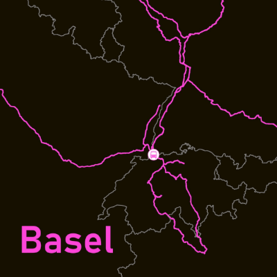
Cross-border railway lines from .... (2024)
The stations of Strasbourg, Karlsruhe, Freiburg im Breisgau and Basel have been selected to illustrate the main cross-border rail links that serve them. The stations chosen for the Greater Region are Luxembourg, Namur, Koblenz and Metz. These are the stations with the most cross-border connections in each country.
This representation is based on a precise methodology: only lines passing through at least two stations located in a different country from the reference station have been selected.
The computer graphics, which are deliberately schematic, show at a glance the density and direction of these rail connections, which are essential to cross-border mobility.
Simple
- Date (Creation)
- 2024-12-13
- Date (Publication)
- 2025-03-18
- Citation identifier
- depart_depuis_RS
- Status
- Completed
- Point of contact
-
Organisation name Individual name Electronic mail address Role GeoRhena
GeoRhena
Custodian
- Maintenance and update frequency
- Not planned
- Keywords
-
-
Upper Rhine
-
Map
-
-
GEMET - Concepts, version 2.4
-
-
transportation
-
public transport
-
train
-
co-operation
-
boundary crossing
-
- Use limitation
-
CC BY Licence ((©GeoRhena ; ©Openstreetmap Contributors)
- Access constraints
- Other restrictions
- Use constraints
- Other restrictions
- Other constraints
-
No other limitation
- Denominator
- 100000
- Language
- Français
- Language
- Deutsch
- Language
- English
- Character set
- UTF8
- Topic category
-
- Transportation
- Begin date
- 2024-01-01
- End date
- 2024-12-31
- Distribution format
-
Name Version PDF Map
-
Digital transfer options
- OnLine resource
-
Protocol Linkage Name WWW:DOWNLOAD-1.0-http--download https://www.georhena.eu/sites/default/files/Cartes/depart_depuis_GR.pdf Cross-border train lines departing from the main stations on the Great Region (2024)
WWW:DOWNLOAD-1.0-http--download https://www.georhena.eu/sites/default/files/Cartes/depart_depuis_RS.pdf Cross-border train lines departing from the main stations on the Upper Rhine (2024)
- Statement
-
The data used to create this map was extracted from Openstreetmap in 2024.
Metadata
- File identifier
- 5db9f8f7-7cbc-4852-8b53-a992f762b982 XML
- Metadata language
- Français
- Character set
- UTF8
- Hierarchy level
- staticMap
- Hierarchy level name
-
Carte statique
- Date stamp
- 2025-03-19T09:11:30.577992Z
- Metadata standard name
-
ISO 19115:2003/19139
- Metadata standard version
-
1.0
- Metadata author
-
Organisation name Individual name Electronic mail address Role GeoRhena: Geographical Information System of the Upper Rhine
Author
- Other language
-
Language Character encoding German UTF8 English UTF8 French UTF8